Open Geospatial Consortium
External identifier of this OGC® document: http://www.opengis.net/doc/IS/geopackage/1.2
URL for this OGC® document: http://www.geopackage.org/spec
Internal reference number of this OGC® document: OGC 12-128r14
Version: 1.2
Category: OGC® Encoding Standard
Editor: Jeff Yutzler
Editor Emeritus: Paul Daisey
Previous Version: http://www.opengis.net/doc/IS/geopackage/1.1.0
Publication Date: 2017-08-25
Approval Date: 2017-08-06
Submission Date: 2017-06-07
Original Version: http://www.opengis.net/doc/IS/geopackage/1.0
OGC® GeoPackage Encoding Standard
Copyright © 2017 Open Geospatial Consortium.
To obtain additional rights of use, visit http://www.opengeospatial.org/legal/
This document is an OGC Member approved international standard. This document is available on a royalty free, non-discriminatory basis. Recipients of this document are invited to submit, with their comments, notification of any relevant patent rights of which they are aware and to provide supporting documentation. This is a revision to OGC 12-128r12.
|
Note that the normative text for this standard is located on the OGC website: https://portal.opengeospatial.org/files/12-128r14. If there are any differences from this HTML document and the normative document, the normative document takes precedence. |
Document type: OGC® Standard
Document subtype: Encoding Standard
Document stage: Approved
Document language: English
License Agreement
Permission is hereby granted by the Open Geospatial Consortium, ("Licensor"), free of charge and subject to the terms set forth below, to any person obtaining a copy of this Intellectual Property and any associated documentation, to deal in the Intellectual Property without restriction (except as set forth below), including without limitation the rights to implement, use, copy, modify, merge, publish, distribute, and/or sublicense copies of the Intellectual Property, and to permit persons to whom the Intellectual Property is furnished to do so, provided that all copyright notices on the intellectual property are retained intact and that each person to whom the Intellectual Property is furnished agrees to the terms of this Agreement.
If you modify the Intellectual Property, all copies of the modified Intellectual Property must include, in addition to the above copyright notice, a notice that the Intellectual Property includes modifications that have not been approved or adopted by LICENSOR.
THIS LICENSE IS A COPYRIGHT LICENSE ONLY, AND DOES NOT CONVEY ANY RIGHTS UNDER ANY PATENTS THAT MAY BE IN FORCE ANYWHERE IN THE WORLD.
THE INTELLECTUAL PROPERTY IS PROVIDED "AS IS", WITHOUT WARRANTY OF ANY KIND, EXPRESS OR IMPLIED, INCLUDING BUT NOT LIMITED TO THE WARRANTIES OF MERCHANTABILITY, FITNESS FOR A PARTICULAR PURPOSE, AND NONINFRINGEMENT OF THIRD PARTY RIGHTS. THE COPYRIGHT HOLDER OR HOLDERS INCLUDED IN THIS NOTICE DO NOT WARRANT THAT THE FUNCTIONS CONTAINED IN THE INTELLECTUAL PROPERTY WILL MEET YOUR REQUIREMENTS OR THAT THE OPERATION OF THE INTELLECTUAL PROPERTY WILL BE UNINTERRUPTED OR ERROR FREE. ANY USE OF THE INTELLECTUAL PROPERTY SHALL BE MADE ENTIRELY AT THE USER’S OWN RISK. IN NO EVENT SHALL THE COPYRIGHT HOLDER OR ANY CONTRIBUTOR OF INTELLECTUAL PROPERTY RIGHTS TO THE INTELLECTUAL PROPERTY BE LIABLE FOR ANY CLAIM, OR ANY DIRECT, SPECIAL, INDIRECT OR CONSEQUENTIAL DAMAGES, OR ANY DAMAGES WHATSOEVER RESULTING FROM ANY ALLEGED INFRINGEMENT OR ANY LOSS OF USE, DATA OR PROFITS, WHETHER IN AN ACTION OF CONTRACT, NEGLIGENCE OR UNDER ANY OTHER LEGAL THEORY, ARISING OUT OF OR IN CONNECTION WITH THE IMPLEMENTATION, USE, COMMERCIALIZATION OR PERFORMANCE OF THIS INTELLECTUAL PROPERTY.
This license is effective until terminated. You may terminate it at any time by destroying the Intellectual Property together with all copies in any form. The license will also terminate if you fail to comply with any term or condition of this Agreement. Except as provided in the following sentence, no such termination of this license shall require the termination of any third party end-user sublicense to the Intellectual Property which is in force as of the date of notice of such termination. In addition, should the Intellectual Property, or the operation of the Intellectual Property, infringe, or in LICENSOR’s sole opinion be likely to infringe, any patent, copyright, trademark or other right of a third party, you agree that LICENSOR, in its sole discretion, may terminate this license without any compensation or liability to you, your licensees or any other party. You agree upon termination of any kind to destroy or cause to be destroyed the Intellectual Property together with all copies in any form, whether held by you or by any third party.
Except as contained in this notice, the name of LICENSOR or of any other holder of a copyright in all or part of the Intellectual Property shall not be used in advertising or otherwise to promote the sale, use or other dealings in this Intellectual Property without prior written authorization of LICENSOR or such copyright holder. LICENSOR is and shall at all times be the sole entity that may authorize you or any third party to use certification marks, trademarks or other special designations to indicate compliance with any LICENSOR standards or specifications.
This Agreement is governed by the laws of the Commonwealth of Massachusetts. The application to this Agreement of the United Nations Convention on Contracts for the International Sale of Goods is hereby expressly excluded. In the event any provision of this Agreement shall be deemed unenforceable, void or invalid, such provision shall be modified so as to make it valid and enforceable, and as so modified the entire Agreement shall remain in full force and effect. No decision, action or inaction by LICENSOR shall be construed to be a waiver of any rights or remedies available to it. None of the Intellectual Property or underlying information or technology may be downloaded or otherwise exported or reexported in violation of U.S. export laws and regulations. In addition, you are responsible for complying with any local laws in your jurisdiction which may impact your right to import, export or use the Intellectual Property, and you represent that you have complied with any regulations or registration procedures required by applicable law to make this license enforceable.
Patent Call
Attention is drawn to the possibility that some of the elements of this document may be the subject of patent rights. The Open Geospatial Consortium shall not be held responsible for identifying any or all such patent rights.
Recipients of this document are requested to submit, with their comments, notification of any relevant patent claims or other intellectual property rights of which they may be aware that might be infringed by any implementation of the standard set forth in this document, and to provide supporting documentation.
- OGC® GeoPackage Encoding Standard
-
- License Agreement
- Patent Call
- Abstract
- Keywords
- Introduction
- 1. Base
- 2. Options
- 3. Security Considerations
- Annex A: Conformance / Abstract Test Suite (Normative)
- Annex B: Background and Context (Normative)
-
- B.1. Background
- B.2. Document terms and definitions
- B.3. Conventions
- B.4. Submitting Organizations (Informative)
- B.5. Document contributor contact points (Informative)
- B.6. Revision History (Informative)
- B.7. Changes to the OGC® Abstract Specification
- B.8. Changes to OGC® Implementation Standards
- B.9. Potential Future Work (Informative)
- B.10. UML Notation
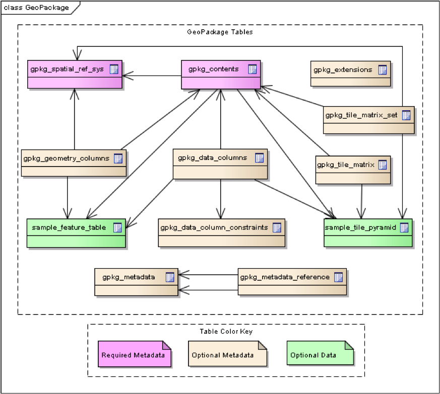
- B.11. GeoPackage Tables Detailed Diagram
- B.12. GeoPackage Minimal Tables for Features Diagram
- B.13. GeoPackage Minimal Tables for Tiles Diagram
- Annex C: Table Definition SQL (Normative)
- Annex D: Trigger Definition SQL (Informative)
- Annex E: GeoPackage Extension Template (Informative)
- Annex F: Registered Extensions (Normative)
-
- F.1. GeoPackage Non-Linear Geometry Types
- F.2. User Defined Geometry Types Extension of GeoPackageBinary Geometry Encoding
- F.3. RTree Spatial Indexes
- F.4. Geometry Type Triggers
- F.5. Geometry SRS ID Triggers
- F.6. Zoom Other Intervals
- F.7. Tiles Encoding WebP
- F.8. Metadata
- F.9. Schema
- F.10. WKT for Coordinate Reference Systems
- F.11. Tiled Gridded Elevation Data
- Annex G: Geometry Types (Normative)
- Annex H: Tiles Zoom Times Two Example (Informative)
- Annex I: Normative References (Normative)
- Annex J: Bibliography (Informative)
- Annex K: Endnotes
Abstract
This OGC® Encoding Standard defines GeoPackages for exchange and GeoPackage SQLite Extensions for direct use of vector geospatial features and / or tile matrix sets of earth images and raster maps at various scales. Direct use means the ability to access and update data in a "native" storage format without intermediate format translations in an environment (e.g. through an API) that guarantees data model and data set integrity and identical access and update results in response to identical requests from different client applications. GeoPackages are interoperable across all enterprise and personal computing environments, and are particularly useful on mobile devices like cell phones and tablets in communications environments with limited connectivity and bandwidth.
Keywords
ogcdoc, geopackage, sqlite, raster, tiles, vector, feature, data, storage, exchange, mobile, smartphone, tablet
Introduction
A GeoPackage is an open, standards-based, platform-independent, portable, self-describing, compact format for transferring geospatial information. It is a platform-independent SQLite [5] database file that contains the GeoPackage data and metadata tables shown in GeoPackage Tables Overview below.
The GeoPackage Encoding Standard (this document) describes a set of conventions for storing the following within an SQLite database:
-
vector features
-
tile matrix sets of imagery and raster maps at various scales
-
attributes (non-spatial data)
-
extensions
These conventions include table definitions, integrity assertions, format limitations, and content constraints. The required and supported content of a GeoPackage is entirely defined in the standard. These capabilities are built on a common base and the extension mechanism provides implementors a way to include additional functionality in their GeoPackages.
Since a GeoPackage is a database container, it supports direct use. This means that the data in a GeoPackage can be accessed and updated in a "native" storage format without intermediate format translations. GeoPackages that comply with the requirements in the standard and do not implement vendor-specific extensions are interoperable across all enterprise and personal computing environments. GeoPackages are particularly useful on mobile devices such as cell phones and tablets in communications environments where there is limited connectivity and bandwidth.Mobile device users who require map/geospatial application services and operate in disconnected or limited network connectivity environments are challenged by limited storage capacity and the lack of open format geospatial data to support these applications.
This standard is intended to facilitate widespread adoption and use of GeoPackages by both COTS and open-source software applications on enterprise production platforms as well as mobile hand-held devices [B1] [B2], given that mobile hand held devices do not yet have the processing power or battery life to effectively tackle difficult geospatial product production and analysis tasks.
An Extended GeoPackage is a GeoPackage that contains any additional data elements (tables or columns) or SQL constructs (views, data types, functions, indexes, constraints or triggers) that are not automatically maintained within the SQLite data file or that result in a change in behavior not specified in this encoding standard.
A GeoPackage MAY be "empty" (contain user data table(s) for vector features, non-spatial attributes, and/or tile matrix pyramids with no row record content) or contain one or many vector feature type records and /or one or many tile matrix pyramid tile images. GeoPackage metadata CAN describe GeoPackage data contents and identify external data synchronization sources and targets. A GeoPackage MAY contain spatial indexes on feature geometries and SQL triggers to maintain indexes and enforce content constraints.
A GeoPackage SQLite Configuration consists of the SQLite 3 software library and a set of compile- and runtime configurations options.
A GeoPackage SQLite Extension is a SQLite loadable extension that MAY provide SQL functions [12] to support spatial indexes and SQL triggers linked to a SQLite library with specified configuration requirements to provide SQL API [1] [2] [3] [4] access to a GeoPackage file. This standard does not address the issues listed in the [_potential_future_work] clause in Background and Context (Normative), which MAY be addressed in a subsequent version of this standard or by other specifications.
1. Base
The required capabilities specified in this clause serve as the base for options specified in clause Options and extensions specified in clause Registered Extensions (Normative). All gpkg_* tables and views and all tiles user data tables specified in this standard SHALL have only the specified columns and table constraints. Any features user data tables MAY have columns in addition to those specified. All specified table, view, column, trigger, and constraint name values SHALL be lowercase.
1.1. Core
The mandatory core capabilities defined in sub clauses and requirement statements of this clause SHALL be implemented by every GeoPackage and GeoPackage SQLite Configuration.
1.1.1. SQLite Container
The SQLite software library provides a self-contained, single-file, cross-platform, serverless, transactional, open source RDBMS container. The GeoPackage standard defines a SQL database schema designed for use with the SQLite software library. Using SQLite as the basis for GeoPackage simplifies production, distribution and use of GeoPackages and assists in guaranteeing the integrity of the data they contain.
"Self-contained" means that container software requires very minimal support from external libraries or from the operating system. "Single-file" means that a container not currently opened by any software application consists of a single file in a file system supported by a computing platform operating system. "Cross-platform" means that a container file MAY be created and loaded with data on one computing platform, and used and updated on another, even if they use different operating systems, file systems, and byte order (endian) conventions. "Serverless" means that the RDBMS container is implemented without any intermediary server process, and accessed directly by application software. "Transactional" means that RDBMS transactions guarantee that all changes to data in the container are Atomic, Consistent, Isolated, and Durable (ACID) despite program crashes, operating system crashes, and power failures.
1.1.1.1. Data
1.1.1.1.1. File Format
A GeoPackage SHALL contain a value of 0x47504B47 ("GPKG" in ASCII) in the "application_id" field of the SQLite database header to indicate that it is a GeoPackage. [K3] A GeoPackage SHALL contain an appropriate value in "user_version" field of the SQLite database header to indicate its version. The value SHALL be in integer with a major version, two-digit minor version, and two-digit bug-fix. For GeoPackage Version 1.2 this value is 0x000027D8 (the hexadecimal value for 10200). [K4]
The maximum size of a GeoPackage file is about 140TB. In practice a lower size limit MAY be imposed by the filesystem to which the file is written. Many mobile devices require external memory cards to be formatted using the FAT32 file system which imposes a maximum size limit of 4GB.
1.1.1.1.2. File Extension Name
A GeoPackage SHALL have the file extension name ".gpkg".
It is RECOMMENDED that Extended GeoPackages use the file extension ".gpkx", but this is NOT a GeoPackage requirement.
1.1.1.1.3. File Contents
A GeoPackage SHALL only contain the data elements (tables, columns, or values) and SQL constructs (views, constraints, or triggers) specified in the core of this encoding standard (Features, Tiles, and Attributes). Extended GeoPackages MAY contain additional data elements and SQL constructs as specified through the Extension Mechanism.
The GeoPackage designation is designed to provide maximum interoperability between applications. In an Extended GeoPackage, the extension mechanism is used to provide additional capabilities in a way that maintains interoperability as much as possible. Developers are encouraged to consider the implications of extensions when designing their applications. Best practices include the following:
-
Designing in a way that anticipates the presence of unexpected extensions, e.g., gracefully handling unexpected columns, values, or encodings.
-
Using the RTree Spatial Indexes extension for GeoPackages containing a non-trivial amount of vector data.
-
Using the WKT for Coordinate Reference Systems extension, which is strongly recommended due to inherent weaknesses in the original standard for encoding coordinate reference systems.
The columns of tables in a GeoPackage SHALL only be declared using one of the data types specified in table GeoPackage Data Types. Extended GeoPackages MAY contain additional data types as specified through the Extension Mechanism.
| Data Type | Size and Description |
|---|---|
BOOLEAN |
A boolean value representing true or false. Stored as SQLite INTEGER with value 0 for false or 1 for true. |
TINYINT |
8-bit signed two’s complement integer. Stored as SQLite INTEGER with values in the range [-128, 127]. |
SMALLINT |
16-bit signed two’s complement integer. Stored as SQLite INTEGER with values in the range [-32768, 32767]. |
MEDIUMINT |
32-bit signed two’s complement integer. Stored as SQLite INTEGER with values in the range [-2147483648, 2147483647]. |
INT, INTEGER |
64-bit signed two’s complement integer. Stored as SQLite INTEGER with values in the range [-9223372036854775808, 9223372036854775807]. |
FLOAT |
32-bit IEEE floating point number. Stored as SQLite REAL limited to values that can be represented as a 4-byte IEEE floating point number. |
DOUBLE, REAL |
64-bit IEEE floating point number. Stored as SQLite REAL. |
TEXT{(maxchar_count)} |
Variable length string encoded in either UTF-8 or UTF-16, determined by PRAGMA encoding; see http://www.sqlite.org/pragma.html#pragma_encoding. The optional maxchar_count defines the maximum number of characters in the string. If not specified, the length is unbounded. The count is provided for informational purposes, and applications MAY choose to truncate longer strings if encountered. When present, it is best practice for applications to adhere to the character count. Stored as SQLite TEXT. |
BLOB{(max_size)} |
Variable length binary data. The optional max_size defines the maximum number of bytes in the blob. If not specified, the length is unbounded. The size is provided for informational purposes. When present, it is best practice for applications adhere to the maximum blob size. Stored as SQLite BLOB. |
<geometry_type_name> |
Geometry encoded as per clause Geometry Encoding. <geometry type_name> is one of the core geometry types listed in Geometry Types (Normative) encoded per clause 2.1.3 or a geometry type encoded per an extension such as GeoPackage Non-Linear Geometry Types. Geometry Types XY, XYZ, XYM and XYZM geometries use the same data type. Stored as SQLite BLOB. |
DATE |
ISO-8601 date string in the form YYYY-MM-DD encoded in either UTF-8 or UTF-16. See TEXT. Stored as SQLite TEXT. |
DATETIME |
ISO-8601 date/time string in the form YYYY-MM-DDTHH:MM:SS.SSSZ with T separator character and Z suffix for coordinated universal time (UTC) encoded in either UTF-8 or UTF-16. See TEXT. Stored as SQLite TEXT. |
1.1.1.1.4. File Integrity
The SQLite PRAGMA integrity_check SQL command SHALL return "ok" for a GeoPackage file. [K5]
The SQLite PRAGMA foreign_key_check SQL with no parameter value SHALL return an empty result set indicating no invalid foreign key values for a GeoPackage file.
1.1.1.2. API
1.1.1.2.1. Structured Query Language (SQL)
A GeoPackage SQLite Configuration SHALL provide SQL access to GeoPackage contents via SQLite version 3 [6] software APIs. [K6]
1.1.1.2.2. Every GPKG SQLite Configuration
The SQLite [8] library has many compile time and run time options that MAY be used to configure SQLite for different uses. Use of SQLITE_OMIT options is not recommended because certain elements of the GeoPackage standard depend on the availability of SQLite functionality at runtime.
Every GeoPackage SQLite Configuration SHALL have the SQLite library compile time options specified in clause 1.1.1.2.2 table [every_gpkg_sqlite_config_table].
1.1.2. Spatial Reference Systems
1.1.2.1. Data
1.1.2.1.1. Table Definition
A GeoPackage SHALL include a gpkg_spatial_ref_sys table per clause 1.1.2.1.1 Table Definition, Table Spatial Ref Sys Table Definition and Table gpkg_spatial_ref_sys Table Definition SQL.
A table named gpkg_spatial_ref_sys is the first component of the standard SQL schema for simple features described in clause Simple Features SQL Introduction below.
The coordinate reference system definitions it contains are referenced by the GeoPackage gpkg_contents and gpkg_geometry_columns tables to relate the vector and tile data in user tables to locations on the earth.
The gpkg_spatial_ref_sys table includes the columns specified in SQL/MM (ISO 13249-3) [12] and shown in Spatial Ref Sys Table Definition below containing data that defines spatial reference systems.
Views of this table MAY be used to provide compatibility with the SQL/MM [12] (see SQL/MM View of gpkg_spatial_ref_sys Definition SQL (Informative)) and OGC Simple Features SQL [9][10][11] (Table 21) standards.
| Column Name | Column Type | Column Description | Null | Key |
|---|---|---|---|---|
|
TEXT |
Human readable name of this SRS |
no |
|
|
INTEGER |
Unique identifier for each Spatial Reference System within a GeoPackage |
no |
PK |
|
TEXT |
Case-insensitive name of the defining organization e.g. EPSG or epsg |
no |
|
|
INTEGER |
Numeric ID of the Spatial Reference System assigned by the organization |
no |
|
|
TEXT |
Well-known Text [32] Representation of the Spatial Reference System |
no |
|
|
TEXT |
Human readable description of this SRS |
yes |
1.1.2.1.2. Table Data Values
Definition column WKT values in the gpkg_spatial_ref_sys table define the Spatial Reference Systems used by feature geometries and tile images, unless these SRSs are unknown and therefore undefined as specified in Requirement 11. Values are constructed per the EBNF syntax in [32] clause 7. EBNF name and number values may be obtained from any specified authority, e.g. [13][14]. For example, see the return value in [spatial_ref_sys_data_values_default] Test Method step (3) used to test the definition for WGS-84 per Requirement 11:
The gpkg_spatial_ref_sys table SHALL contain at a minimum the records listed in Spatial Ref Sys Table Records. The record with an srs_id of 4326 SHALL correspond to WGS-84 [15] as defined by EPSG [B3] in 4326 [13][14]. The record with an srs_id of -1 SHALL be used for undefined Cartesian coordinate reference systems. The record with an srs_id of 0 SHALL be used for undefined geographic coordinate reference systems.
srs_name |
srs_id |
organization |
organization_coordsys_id |
definition |
description |
|---|---|---|---|---|---|
any |
4326 |
|
4326 |
any |
any |
any |
-1 |
|
-1 |
|
any |
any |
0 |
|
0 |
|
any |
The gpkg_spatial_ref_sys table in a GeoPackage SHALL contain records to define all spatial reference systems used by features and tiles in a GeoPackage.
1.1.3. Contents
The gpkg_contents table is intended to provide a list of all geospatial contents in a GeoPackage. It provides identifying and descriptive information that an application can display to a user as a menu of geospatial data that is available for access and/or update.
1.1.3.1. Data
1.1.3.1.1. Table Definition
A GeoPackage file SHALL include a gpkg_contents table per table Contents Table Definition and gpkg_contents Table Definition SQL.
| Column Name | Type | Description | Null | Default | Key |
|---|---|---|---|---|---|
|
TEXT |
The name of the tiles, or feature table |
no |
PK |
|
|
TEXT |
Type of data stored in the table |
no |
||
|
TEXT |
A human-readable identifier (e.g. short name) for the table_name content |
yes |
UNIQUE |
|
|
TEXT |
A human-readable description for the table_name content |
yes |
'' |
|
|
DATETIME |
timestamp of last change to content, in ISO 8601 format |
no |
|
|
|
DOUBLE |
Bounding box minimum easting or longitude for all content in table_name |
yes |
||
|
DOUBLE |
Bounding box minimum northing or latitude for all content in table_name |
yes |
||
|
DOUBLE |
Bounding box maximum easting or longitude for all content in table_name |
yes |
||
|
DOUBLE |
Bounding box maximum northing or latitude for all content in table_name |
yes |
||
|
INTEGER |
Spatial Reference System ID: |
yes |
FK |
1.1.3.1.2. Table Data Values
The table_name column value in a gpkg_contents table row SHALL contain the name of a SQLite table or view.
The data_type specifies the type of content contained in the table, for example "features" per clause Features, "attributes" per clause Attributes, "tiles" per clause Tiles, or an implementer-defined value for other data tables per clause in an Extended GeoPackage.
The last_change SHOULD contain the timestamp of when the content in the referenced table was last updated, in ISO8601 format. Note that since it is not practical to ensure that this value is maintained properly in all cases, this value should be treated as informative.
Values of the gpkg_contents table last_change column SHALL be in ISO 8601 [29] format containing a complete date plus UTC hours, minutes, seconds and a decimal fraction of a second, with a Z (zulu) suffix indicating UTC. The ISO8601 format is as defined by the strftime function %Y-%m-%dT%H:%M:%fZ format string applied to the current time. [K7]
The bounding box (min_x, min_y, max_x, max_y) provides an informative bounding box of the content. Applications may use this bounding box as the extents of a default view but there are no requirements that this bounding box be exact or represent the minimum bounding box of the content. The values are in the units specified by that CRS.
Values of the gpkg_contents table srs_id column SHALL reference values in the gpkg_spatial_ref_sys table srs_id column.
2. Options
The optional capabilities specified in this clause depend on the required capabilities specified in clause Base above. Each subclause of this clause defines an indivisible module of functionality that can be used in GeoPackages. These modules are referred to as options. GeoPackages MAY use one or more options defined in this section. GeoPackages MAY omit the tables for options that are not used. At a minimum, a GeoPackage SHOULD contain at least one user data table as defined by the Features, Tiles, or Attributes options in clauses Features, Tiles, and Attributes respectively.
2.1. Features
2.1.1. Simple Features SQL Introduction
Vector feature data represents geolocated entities including conceptual ones such as districts, real world objects such as roads and rivers, and observations thereof.
International standards [9][10][11][12] have standardized practices for the storage, access and use of vector geospatial features and geometries via SQL in relational databases.
The first component of the SQL schema for vector features in a GeoPackage is the gpkg_spatial_ref_sys table defined in clause Spatial Reference Systems above.
Other components are defined below.
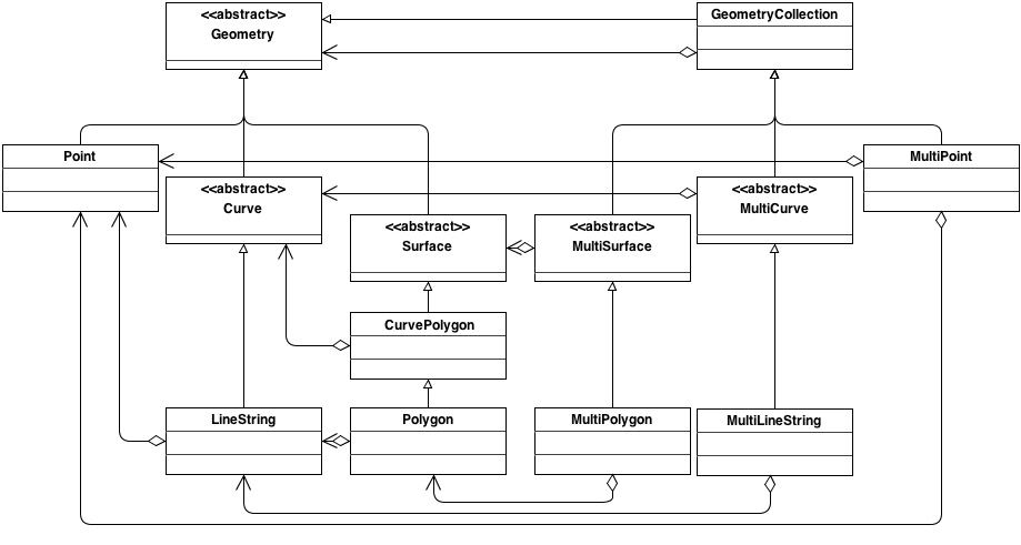
In a GeoPackage, "simple" features are geolocated using a linear geometry subset of the SQL/MM (ISO 13249-3) [12] geometry model shown in Core Geometry Model below.
The instantiable (not abstract) geometry types defined in this Standard are restricted to 0, 1 and 2-dimensional geometric objects that exist in 2, 3 or 4-dimensional coordinate space (R2, R3 or R4). Geometry values in R2 have points with coordinate values for x and y. Geometry values in R3 have points with coordinate values for x, y and z or for x, y and m. Geometry values in R4 have points with coordinate values for x, y, z and m. The interpretation of the coordinates is subject to the coordinate reference systems associated to the point. All coordinates within a geometry object should be in the same coordinate reference systems.
Geometries MAY include z coordinate values. The z coordinate value traditionally represents the third dimension (i.e. 3D). In a Geographic Information System (GIS) this may be height above or below sea level. For example: A map might have a point identifying the position of a mountain peak by its location on the earth, with the x and y coordinate values, and the height of the mountain, with the z coordinate value.
Geometries MAY include m coordinate values. The m coordinate value allows the application environment to associate some measure with the point values. For example: A stream network may be modeled as multilinestring value with the m coordinate values measuring the distance from the mouth of stream.
A brief description of each geometry type is provided below. A more detailed description can be found in ISO 13249-3 [12].
-
Geometry: the root of the geometry type hierarchy.
-
Point: a single location in space. Each point has an X and Y coordinate. A point MAY optionally also have a Z and/or an M value.
-
Curve: the base type for all 1-dimensional geometry types. A 1-dimensional geometry is a geometry that has a length, but no area. A curve is considered simple if it does not intersect itself (except at the start and end point). A curve is considered closed its start and end point are coincident. A simple, closed curve is called a ring.
-
LineString: A Curve that connects two or more points in space.
-
Surface: the base type for all 2-dimensional geometry types. A 2-dimensional geometry is a geometry that has an area.
-
CurvePolygon: A planar surface defined by an exterior ring and zero or more interior ring. Each ring is defined by a Curve instance.
-
Polygon: A restricted form of CurvePolygon where each ring is defined as a simple, closed LineString.
-
GeometryCollection: A collection of zero or more Geometry instances. [K8]
-
MultiSurface: A restricted form of GeometryCollection where each Geometry in the collection must be of type Surface.
-
MultiPolygon: A restricted form of MultiSurface where each Surface in the collection must be of type Polygon.
-
MultiCurve: A restricted form of GeometryCollection where each Geometry in the collection must be of type Curve.
-
MultiLineString: A restricted form of MultiCurve where each Curve in the collection must be of type LineString.
-
MultiPoint: A restricted form of GeometryCollection where each Geometry in the collection must be of type Point.
2.1.2. Contents
2.1.2.1. Data
2.1.2.1.1. Contents Table – Features Row
The gpkg_contents table SHALL contain a row with a lowercase data_type column value of "features" for each vector features user data table or view.
2.1.3. Geometry Encoding
2.1.3.1. Data
2.1.3.1.1. BLOB Format
A GeoPackage SHALL store feature table geometries with or without optional elevation (Z) and/or measure (M) values in SQL BLOBs using the Standard GeoPackageBinary format specified in table GeoPackage SQL Geometry Binary Format and clause BLOB Format.
GeoPackageBinaryHeader {
  byte[2] magic = 0x4750; (1)
  byte version;           (2)
  byte flags;             (3)
  int32 srs_id;
  double[] envelope;      (4)
}

StandardGeoPackageBinary {
  GeoPackageBinaryHeader header; (5)
  WKBGeometry geometry;          (6)
}
| 1 | GP in ASCII |
| 2 | 8-bit unsigned integer, 0 = version 1 |
| 3 | see bit layout of GeoPackageBinary flags byte |
| 4 | see flags envelope contents indicator code below |
| 5 | The X bit in the header flags field must be set to 0. |
| 6 | per OGC 06-103r4 [9] [K9] [K10] [K11] |
bit |
7 |
6 |
5 |
4 |
3 |
2 |
1 |
0 |
use |
R |
R |
X |
Y |
E |
E |
E |
B |
flag bits use:
-
R: reserved for future use; set to 0
-
X: GeoPackageBinary type
-
0: StandardGeoPackageBinary. See below
-
1: ExtendedGeoPackageBinary. See User Defined Geometry Types Extension of GeoPackageBinary Geometry Encoding.
-
-
Y: empty geometry flag
-
0: non-empty geometry
-
1: empty geometry
-
-
E: envelope contents indicator code (3-bit unsigned integer)
-
0: no envelope (space saving slower indexing option), 0 bytes
-
1: envelope is [minx, maxx, miny, maxy], 32 bytes
-
2: envelope is [minx, maxx, miny, maxy, minz, maxz], 48 bytes
-
3: envelope is [minx, maxx, miny, maxy, minm, maxm], 48 bytes
-
4: envelope is [minx, maxx, miny, maxy, minz, maxz, minm, maxm], 64 bytes
-
5-7: invalid
-
-
B: byte order for header values (1-bit Boolean)
-
0: Big Endian (most significant byte first)
-
1: Little Endian (least significant byte first)
-
Well-Known Binary as defined in OGC 06-103r4 [9] does not provide a standardized encoding for an empty point set (i.e., Point Empty in Well-Known Text). In GeoPackages these points SHALL be encoded as a Point where each coordinate value is set to an IEEE-754 quiet NaN value. GeoPackages SHALL use big endian 0x7ff8000000000000 or little endian 0x000000000000f87f as the binary encoding of the NaN values.
When the WKBGeometry in a GeoPackageBinary is empty, either the envelope contents indicator code SHALL be 0 indicating no envelope, or the envelope SHALL have its values set to NaN as defined for an empty point.
2.1.4. SQL Geometry Types
2.1.4.1. Data
2.1.4.1.1. Core Types
A GeoPackage SHALL store feature table geometries with the basic simple feature geometry types (Geometry, Point, LineString, Polygon, MultiPoint, MultiLineString, MultiPolygon, GeomCollection) in Geometry Types (Normative) Geometry Type Codes (Core) in the GeoPackageBinary geometry encoding format.
2.1.5. Geometry Columns
2.1.5.1. Data
2.1.5.1.1. Table Definition
A GeoPackage with a gpkg_contents table row with a "features" data_type SHALL contain a gpkg_geometry_columns table per Geometry Columns Table Definition and gpkg_geometry_columns Table Definition SQL.
The second component of the SQL schema for vector features in a GeoPackage is a gpkg_geometry_columns table that
identifies the geometry columns and geometry types in tables that contain user data representing features.
| Column Name | Type | Description | Null | Key |
|---|---|---|---|---|
|
TEXT |
Name of the table containing the geometry column |
no |
PK, FK |
|
TEXT |
Name of a column in the feature table that is a Geometry Column |
no |
PK |
|
TEXT |
Name from Geometry Type Codes (Core) or Geometry Type Codes (Extension) in Geometry Types (Normative) |
no |
|
|
INTEGER |
Spatial Reference System ID: |
no |
FK |
|
TINYINT |
0: z values prohibited; 1: z values mandatory; 2: z values optional |
no |
|
|
TINYINT |
0: m values prohibited; 1: m values mandatory; 2: m values optional |
no |
The FK on gpkg_geometry_columns.srs_id references the PK on gpkg_spatial_ref_sys.srs_id to ensure that geometry columns are only defined in feature tables for defined spatial reference systems.
Views of this table MAY be used to provide compatibility with the SQL/MM [12] SQL/MM View of gpkg_geometry_columns Definition SQL (Informative) and OGC Simple Features SQL [9][10][11] SF/SQL VIEW of gpkg_geometry_columns Definition SQL (Informative) specifications.
2.1.5.1.2. Table Data Values
The gpkg_geometry_columns table SHALL contain one row record for the geometry column in each vector feature data table (clause Vector Feature User Data Tables) in a GeoPackage.
Values of the gpkg_geometry_columns table_name column SHALL reference values in the gpkg_contents table_name column for rows with a data_type of features.
The column_name column value in a gpkg_geometry_columns row SHALL be the name of a column in the table or view specified by the table_name column value for that row.
The geometry_type_name value in a gpkg_geometry_columns row SHALL be one of the uppercase geometry type names specified in Geometry Types (Normative).
The srs_id value in a gpkg_geometry_columns table row SHALL be an srs_id column value from the gpkg_spatial_ref_sys table.
The z value in a gpkg_geometry_columns table row SHALL be one of 0, 1, or 2.
The m value in a gpkg_geometry_columns table row SHALL be one of 0, 1, or 2.
2.1.6. Vector Feature User Data Tables
2.1.6.1. Data
2.1.6.1.1. Table Definition
The third component of the SQL schema for vector features in a GeoPackage described in clause Simple Features SQL Introduction above are tables that contain user data representing features. Feature attributes are columns in a feature table, including geometries. Features are rows in a feature table. [K12]
A GeoPackage MAY contain tables or updateable views containing vector features. Every such feature table or view in a GeoPackage SHALL have a column with column type INTEGER and PRIMARY KEY AUTOINCREMENT column constraints per EXAMPLE : Sample Feature Table or View Definition and sample_feature_table Table Definition SQL (Informative).
The integer primary key of a feature table allows features to be linked to row level metadata records in the gpkg_metadata table by rowid [B5] values in the gpkg_metadata_reference table as described in clause Metadata Reference Table below.
A feature table SHALL have only one geometry column.
Feature data models [B23] from non-GeoPackage implementations that have multiple geometry columns per feature table MAY be transformed into GeoPackage implementations with a separate feature table for each geometry type whose rows have matching integer primary key values that allow them to be joined in a view with the same column definitions as the non-GeoPackage feature data model with multiple geometry columns.
The declared SQL type of the geometry column in a vector feature user data table SHALL be specified by the geometry_type_name column for that column_name and table_name in the gpkg_geometry_columns table.
| Column Name | Type | Description | Null | Default | Key |
|---|---|---|---|---|---|
|
INTEGER |
Autoincrement primary key |
no |
PK |
|
|
GEOMETRY |
GeoPackage Geometry |
yes |
||
|
TEXT |
Text attribute of feature |
yes |
||
|
REAL |
Real attribute of feature |
yes |
||
|
BOOLEAN |
Boolean attribute of feature |
yes |
||
|
BLOB |
Photograph of the area |
yes |
2.1.6.1.2. Table Data Values
A feature geometry is stored in a geometry column specified by the geometry_column value for the feature table in the gpkg_geometry_columns table defined in clause Geometry Columns above.
The geometry type of a feature geometry column specified in the gpkg_geometry_columns table geometry_type_name column is a name from Geometry Types (Normative).
Feature table geometry columns SHALL contain geometries of the type or assignable for the type specified for the column by the gpkg_geometry_columns table geometry_type_name uppercase column value [K13]
Geometry subtypes are assignable as defined in Geometry Types (Normative) and shown in part in Core Geometry Model.
For example, if the geometry_type_name value in the gpkg_geometry_columns table is for a geometry type like POINT that has no subtypes, then the feature table geometry column MAY only contain geometries of that type.
If the geometry type_name value in the gpkg_geometry_columns table is for a geometry type like GEOMCOLLECTION that has subtypes, then the feature table geometry column MAY only contain geometries of that type or any of its direct or indirect subtypes.
If the geometry type_name is GEOMETRY (the root of the geometry type hierarchy) then the feature table geometry column MAY contain geometries of any geometry type.
The presence or absence of optional elevation (Z) and/or measure (M) values in a geometry does not change its type or assignability. The unit of measure for optional elevation(Z) values is determined by the CRS of the geometry; it is as-defined by a 3D CRS, and undefined for a 2D CRS. The unit of measure for optional measure (M) values is determined by the CRS of the geometry.
The spatial reference system type of a feature geometry column specified by a gpkg_geometry_columns table srs_id column value is a code from the gpkg_spatial_ref_sys table srs_id column.
Feature table geometry columns SHALL contain geometries with the srs_id specified for the column by the gpkg_geometry_columns table srs_id column value.
2.2. Tiles
2.2.1. Tile Matrix Introduction
The Tiles option specifies a mechanism for storing raster data in tile pyramids. "Tile pyramid" refers to the concept of pyramid structure of tiles of different spatial extent and resolution at different zoom levels, and the tile data itself. "Tile" refers to an individual raster image such as a PNG or JPEG that covers a specific geographic area. "Tile matrix" refers to rows and columns of tiles that all have the same spatial extent and resolution at a particular zoom level[K14] "Tile matrix set" refers to the definition of a tile pyramid’s tiling structure. This mechanism is based on the model for tile matrix sets described in Section 6 of [16].
The GeoPackage tile store data model MAY be implemented directly as SQL tables in a SQLite database for maximum performance, or as SQL views on top of tables in an existing SQLite tile store for maximum adaptability and loose coupling to enable widespread implementation. A GeoPackage CAN store multiple raster and tile pyramid data sets in different tables or views in the same container. The tables or views that implement the GeoPackage tile store data / metadata model are described and discussed individually in the following subsections.
The tile store data / metadata model and conventions described below support direct use of tiles in a GeoPackage in two ways. First, they specify how existing application MAY create SQL Views of the data / metadata model on top of existing application tables that that follow different interface conventions. Second, they include and expose enough metadata information at both the dataset and record level to allow applications that use GeoPackage data to discover its characteristics without having to parse all of the stored images. Applications that store GeoPackage tile data, which are presumed to have this information available, should store sufficient metadata to enable its intended use.
2.2.2. Contents
2.2.2.1. Data
2.2.2.1.1. Contents Table – Tiles Row
The gpkg_contents table SHALL contain a row with a data_type column value of "tiles" for each tile pyramid user data table or view.
2.2.3. Zoom Levels
In a GeoPackage, zoom levels are integers in sequence from 0 to n that identify tile matrix layers in a tile matrix set that contain tiles of decreasing spatial extent and finer spatial resolution. Adjacent zoom levels immediately precede or follow each other and differ by a value of 1. Pixel sizes are real numbers in the terrain units of the spatial reference system of a tile image specifying the dimensions of the real world area represented by one pixel. Pixel size MAY vary by a constant factor or by different factors or intervals between some or all adjacent zoom levels in a tile matrix set. In the commonly used "zoom times two" convention, pixel sizes vary by a factor of 2 between all adjacent zoom levels, as shown in the example in [tiles_factor2_example_appendix]. Other "zoom other intervals" conventions use different factors or irregular intervals with pixel sizes chosen for intuitive cartographic representation of raster data, or to coincide with the original pixel size of commonly used global image products. See Web Map Tile Service (WMTS) [16] Annex E for additional examples of both conventions.
2.2.3.1. Data
2.2.3.1.1. Zoom Times Two
In a GeoPackage that contains a tile pyramid user data table that contains tile data, by default [K15], zoom level pixel sizes for that table SHALL vary by a factor of 2 between adjacent zoom levels in the tile matrix metadata table.
2.2.4. Tile Encoding PNG
2.2.5. Tile Encoding JPEG
2.2.5.1. Data
2.2.5.1.1. MIME Type JPEG
|
Requirements 36 and 37 in combination allow a tile pyramid user data table to contain PNG or JPG tiles. They may be mixed and matched within the same table. |
2.2.6. Tile Matrix Set
2.2.6.1. Data
2.2.6.1.1. Table Definition
The gpkg_tile_matrix_set table defines the spatial reference system (srs_id) and the maximum bounding box (min_x, min_y, max_x, max_y) for all possible tiles in a tile pyramid user data table.
A GeoPackage that contains a tile pyramid user data table SHALL contain gpkg_tile_matrix_set table per Table Definition, Tile Matrix Set Table Definition and gpkg_tile_matrix_set Table Creation SQL.
| Column Name | Column Type | Column Description | Null | Default | Key |
|---|---|---|---|---|---|
|
TEXT |
Tile Pyramid User Data Table Name |
no |
PK, FK |
|
|
INTEGER |
Spatial Reference System ID: gpkg_spatial_ref_sys.srs_id |
no |
FK |
|
|
DOUBLE |
Bounding box minimum easting or longitude for the tile matrix set |
no |
||
|
DOUBLE |
Bounding box minimum northing or latitude for the tile matrix set |
no |
||
|
DOUBLE |
Bounding box maximum easting or longitude for the tile matrix set |
no |
||
|
DOUBLE |
Bounding box maximum northing or latitude for the tile matrix set |
no |
2.2.6.1.2. Table Data Values
The bounding box defined by min_x, max_x, min_y, and max_y SHALL be exact so that the bounding box coordinates for individual tiles in a tile pyramid MAY be calculated from those values. All tiles present in the tile pyramid SHALL fall within this bounding box.
Since GeoPackages use the upper left tile origin convention defined in clause Table Data Values below, the gpkg_tile_matrix_set (min_x, max_y) ordinate is the upper-left corner of tile (0,0) for all zoom levels in a table_name tile pyramid user data table.
A bounding box MAY be larger than the minimum bounding rectangle around the actual tiles in that pyramid. This allows tile matrix pyramids to be sparsely populated or even empty.
Values of the gpkg_tile_matrix_set table_name column SHALL reference values in the gpkg_contents table_name column for rows with a data type of "tiles"[K18].
The gpkg_tile_matrix_set table SHALL contain one row record for each tile pyramid user data table.
Values of the gpkg_tile_matrix_set srs_id column SHALL reference values in the gpkg_spatial_ref_sys srs_id column.
2.2.7. Tile Matrix
2.2.7.1. Data
2.2.7.1.1. Table Definition
A GeoPackage that contains a tile pyramid user data table SHALL contain a gpkg_tile_matrix table per clause 2.2.7.1.1 Table Definition, Table Tile Matrix Metadata Table Definition and Table gpkg_tile_matrix Table Creation SQL.
| Column Name | Column Type | Column Description | Null | Key |
|---|---|---|---|---|
|
TEXT |
Tile Pyramid User Data Table Name |
no |
PK, FK |
|
INTEGER |
0 <= |
no |
PK |
|
INTEGER |
Number of columns (>= 1) in tile matrix at this zoom level |
no |
|
|
INTEGER |
Number of rows (>= 1) in tile matrix at this zoom level |
no |
|
|
INTEGER |
Tile width in pixels (>= 1)for this zoom level |
no |
|
|
INTEGER |
Tile height in pixels (>= 1) for this zoom level |
no |
|
|
DOUBLE |
In |
no |
|
|
DOUBLE |
In |
no |
The gpkg_tile_matrix table documents the structure of the tile matrix at each zoom level in each tiles table.
It allows GeoPackages to contain rectangular as well as square tiles (e.g. for better representation of polar regions).
It allows tile pyramids with zoom levels that differ in resolution by factors of 2, irregular intervals, or regular intervals other than factors of 2.
2.2.7.1.2. Table Data Values
Values of the gpkg_tile_matrix table_name column SHALL reference values in the gpkg_contents table_name column for rows with a data_type of "tiles".[K19]
The gpkg_tile_matrix table SHALL contain one row record for each zoom level that contains one or more tiles in each tile pyramid user data table or view.
The width of a tile matrix (the difference between min_x and max_x in gpkg_tile_matrix_set) SHALL equal the product of matrix_width, tile_width, and pixel_x_size for that zoom level.
Similarly, height of a tile matrix (the difference between min_y and max_y in gpkg_tile_matrix_set) SHALL equal the product of matrix_height, tile_height, and pixel_y_size for that zoom level.
The gpkg_tile_matrix table MAY contain row records for zoom levels in a tile pyramid user data table that do not contain tiles.
GeoPackages follow the most frequently used conventions of a tile origin at the upper left and a zoom-out-level of 0 for the smallest map scale "whole world" zoom level view [K20], as specified by WMTS [16]. The tile coordinate (0,0) always refers to the tile in the upper left corner of the tile matrix at any zoom level, regardless of the actual availability of that tile.
The zoom_level column value in a gpkg_tile_matrix table row SHALL not be negative.
The matrix_width column value in a gpkg_tile_matrix table row SHALL be greater than 0.
The matrix_height column value in a gpkg_tile_matrix table row SHALL be greater than 0.
The tile_width column value in a gpkg_tile_matrix table row SHALL be greater than 0.
The tile_height column value in a gpkg_tile_matrix table row SHALL be greater than 0.
The pixel_x_size column value in a gpkg_tile_matrix table row SHALL be greater than 0.
The pixel_y_size column value in a gpkg_tile_matrix table row SHALL be greater than 0.
When zoom_level column values in the gpkg_tile_matrix table are sorted in ascending order, the pixel_x_size and pixel_y_size column values in the gpkg_tile_matrix table SHALL appear sorted in descending order.
Tiles MAY or MAY NOT be provided for level 0 or any other particular zoom level. [K21]
This means that a tile matrix set can be sparse, i.e. not contain a tile for any particular position at a certain tile zoom level.
[K22] This does not affect the informative spatial extent stated by the min/max x/y columns values in the gpkg_contents record for the same table_name, the exact spatial extent stated by the min/max x/y columns values in the gpkg_tile_matrix_set record for the same table name, or the tile matrix width and height at that level. [K23]
2.2.8. Tile Pyramid User Data Tables
2.2.8.1. Data
2.2.8.1.1. Table Definition
Each tile matrix set in a GeoPackage SHALL be stored in a different tile pyramid user data table or updateable view with a unique name that SHALL have a column named "id" with column type INTEGER and PRIMARY KEY AUTOINCREMENT column constraints per Clause 2.2.8.1.1 Table Definition, Tiles Table or View Definition and EXAMPLE: tiles table Create Table SQL (Informative).
| Column Name | Column Type | Column Description | Null | Default | Key |
|---|---|---|---|---|---|
|
INTEGER |
Autoincrement primary key |
no |
PK |
|
|
INTEGER |
min(zoom_level) <= |
no |
UK |
|
|
INTEGER |
0 to |
no |
UK |
|
|
INTEGER |
0 to |
no |
UK |
|
|
BLOB |
Of an image MIME type specified in clauses Tile Encoding PNG, Tile Encoding JPEG, [tile_enc_webp] |
no |
2.2.8.1.2. Table Data Values
Each tile pyramid user data table or view [K24] MAY contain tile matrices at zero or more zoom levels of different spatial resolution (map scale).
For each distinct table_name from the gpkg_tile_matrix (tm) table, the tile pyramid (tp) user data table zoom_level column value in a GeoPackage SHALL be in the range min(tm.zoom_level) <= tp.zoom_level <= max(tm.zoom_level).
For each distinct table_name from the gpkg_tile_matrix (tm) table, the tile pyramid (tp) user data table tile_column column value in a GeoPackage SHALL be in the range 0 <= tp.tile_column <= tm.matrix_width – 1 where the tm and tp zoom_level column values are equal.
For each distinct table_name from the gpkg_tile_matrix (tm) table, the tile pyramid (tp) user data table tile_row column value in a GeoPackage SHALL be in the range 0 <= tp.tile_row <= tm.matrix_height – 1 where the tm and tp zoom_level column values are equal.
All tiles at a particular zoom level have the same pixel_x_size and pixel_y_size values specified in the gpkg_tile_matrix row record for that tiles table and zoom level. [K25]
2.3. Extension Mechanism
2.3.1. Introduction
A GeoPackage extension is a set of one or more requirements clauses that either profiles / extends existing requirements clauses in the GeoPackage standard or adds new requirements clauses. Existing requirement clause extension examples include additional geometry types, additional SQL geometry functions, and additional tile image formats. New requirement clause extension examples include spatial indexes, triggers, additional tables, other BLOB column encodings, and other SQL functions. Files that use one or more extensions are by definition Extended GeoPackages. Extensions that have been already approved by OGC are presented in Registered Extensions (Normative). However, additional extensions MAY be approved by OGC outside of the release cycle of this document.
We acknowledge that there are use cases not covered by this standard. Implementers are welcome to use the extension mechanism defined here to develop their own extensions. The extension mechanism provides advantages including discoverability (the extensions in use can be discovered by scanning a single table) and uniformity (declaring that an extension is in use indicates that a defined set of requirements are being met). However, this is a decision that should be made carefully as custom extensions do introduce interoperability risks.
OGC is unable to endorse extensions developed externally. Therefore an Extended GeoPackage containing extensions not developed by OGC will fail Requirement 4. However, a community of interest MAY waive that requirement in its own GeoPackage profile, with the caveat that it must bear the responsibility of endorsing the new extension(s).
Implementers that are interested in developing their own extensions are encouraged to contact OGC to ensure that the extensions are developed in accordance with OGC policies and in a way that minimizes risks to interoperability. OGC will consider adopting externally developed extensions that address a clear use case, have a sound technical approach, and have a commitment to implementation by multiple implementers.
GeoPackage extensions are documented using the GeoPackage Extension Template in GeoPackage Extension Template (Informative). Extensions are identified by a name of the form <author>_<extension name> where <author> indicates the person or organization that developed and maintains the extension. The author value "gpkg" is reserved for extensions that are developed, maintained, and approved by OGC. Implementers must use their own author names to register other extensions used in Extended GeoPackages.
2.3.2. Extensions
2.3.2.1. Data
2.3.2.1.1. Table Definition
A GeoPackage MAY contain a table or updateable view named gpkg_extensions. If present this table SHALL be defined per clause 2.3.2.1.1 Table Definition, GeoPackage Extensions Table or View Definition (Table or View Name: gpkg_extensions), and gpkg_extensions Table Definition SQL. An extension SHALL NOT modify the definition or semantics of existing columns. An extension MAY define additional tables or columns. An extension MAY allow new values or encodings for existing columns.
The gpkg_extensions table or updateable view in a GeoPackage is used to indicate that a particular extension applies to a GeoPackage, a table in a GeoPackage, or a column of a table in a GeoPackage.
An application that accesses a GeoPackage can query the gpkg_extensions table instead of the contents of all the user data tables to determine if it has the required capabilities to read or write to tables with extensions, and to "fail fast" and return an error message if it does not.
| Column Name | Col Type | Column Description | Null | Key |
|---|---|---|---|---|
|
TEXT |
Name of the table that requires the extension. When NULL, the extension is required for the entire GeoPackage. SHALL NOT be NULL when the column_name is not NULL. |
yes |
Jointly Unique |
|
TEXT |
Name of the column that requires the extension. When NULL, the extension is required for the entire table. |
yes |
Jointly Unique |
|
TEXT |
The case sensitive name of the extension that is required, in the form <author>_<extension_name>. |
no |
Jointly Unique |
|
TEXT |
Permalink, URI, or reference to a document that defines the extension |
no |
|
|
TEXT |
Indicates scope of extension effects on readers / writers: read-write or write-only in lowercase. |
no |
2.3.2.1.2. Table Data Values
In an Extended GeoPackage, every extension SHALL be registered in a corresponding row in the gpkg_extensions table. An extension SHALL NOT modify the definition or semantics of existing columns. An extension MAY define additional tables or columns. An extension MAY allow new values or encodings for existing columns.
Either the absence of a gpkg_extensions table or the absence of rows in the gpkg_extensions table SHALL indicate that the file is a GeoPackage (as opposed to an Extended GeoPackage).
Values of the gpkg_extensions table_name column MAY reference values in the gpkg_contents table_name, reference new tables required by that extension, or be NULL (to indicate an extension that requires no new tables).
|
Implementers should be aware of the fact that SQLite table names are not case sensitive and that table names in |
The column_name column value in a gpkg_extensions row SHALL be the name of a column in the table specified by the table_name column value for that row, or be NULL.
Each extension_name column value in a gpkg_extensions row SHALL be a unique case sensitive value of the form <author>_<extension_name> where <author> indicates the person or organization that developed and
maintains the extension. The valid character set for <author> SHALL be [a-zA-Z0-9].
The valid character set for <extension_name> SHALL be [a-zA-Z0-9_].
An extension_name for the "gpkg" author name SHALL be one of those defined in this encoding standard or in an OGC document (e.g. Best Practices Document or Encoding Standard) that extends it.
The author value "gpkg" is reserved for GeoPackage extensions that are developed and maintained by OGC. GeoPackage implementers use their own author names to register other extensions.
The definition column value in a gpkg_extensions row SHALL contain a permalink, URI [23], or reference to a document defining the extension as per the GeoPackage Extension Template (Informative).
Examples of how to fill out the GeoPackage Extension Template in GeoPackage Extension Template (Informative) are provided in Annex F. This column is not unique because an extension may define multiple tables.
The scope column value in a gpkg_extensions row SHALL be lowercase "read-write" for an extension that affects both readers and writers, or "write-only" for an extension that affects only writers.
Some extensions do not impose any additional requirements on software that accesses a GeoPackage in a read-only fashion. An example of this is an extension that defines an SQL trigger that uses a non-standard SQL function defined in a GeoPackage SQLite Extension. Triggers are only invoked when data is written to the GeoPackage, so usage of this type of extension can be safely ignored for read-only access. This is indicated by a gpkg_extensions.scope column value of "write_only".
2.4. Attributes
2.4.1. Introduction
Non-spatial attribute data are sets (or tuples or rows) of observations that may not have an explicit geometry property. In GeoPackage, this data is stored in user-defined attribute tables. These tables may contain properties such as an ID or geo-locatable address that allow them to be relationally linkable to rows in other attribute, feature or tile tables.
Examples of attribute data include:
-
meteorological readings from a weather station
-
flow readings from a stream gauge
-
traffic volumes from embedded highway sensors
-
lists of customers
-
delivery stops
-
work orders
2.4.2. Contents
2.4.2.1. Data
2.4.2.1.1. Contents Table - Attributes Row
The gpkg_contents table SHALL contain a row with a data_type column value of "attributes" for each attributes data table or view.
2.4.3. Attributes User Data Tables
2.4.3.1. Data
2.4.3.1.1. Table Definition
Non-spatial attribute data is stored in user-defined Attribute tables. Attribute sets are rows in an Attribute table. The attributes are columns in a Attribute table. (A GeoPackage is not required to contain any Attribute data tables. Attribute data tables in a GeoPackage may be empty.)
A GeoPackage MAY contain tables or updatable views containing attribute sets. Every such Attribute table or view in a GeoPackage SHALL have a column with column type INTEGER and PRIMARY KEY AUTOINCREMENT column constraints per GeoPackage Attributes Example Table or View Definition and EXAMPLE: Attributes table Create Table SQL (Informative).
The integer primary key of an Attribute table allows attribute sets to be linked to row level metadata records in the gpkg_metadata table by rowid [B5] values in the gpkg_metadata_reference table as described in clause Metadata below.
| Column Name | Col Type | Column Description | Null | Key |
|---|---|---|---|---|
|
INTEGER |
Autoincrement primary key |
no |
PK |
|
TEXT |
Text attribute of feature |
yes |
|
|
REAL |
Real attribute of feature |
yes |
|
|
BOOLEAN |
Boolean attribute of feature |
yes |
|
|
BLOB |
Photo of the area |
yes |
3. Security Considerations
Security considerations for implementations utilizing GeoPackages are in the domain of the implementing application, deployment platform, operating system and networking environment. The GeoPackage standard does not place any constraints on application, platform, operating system level or network security.
Since GeoPackage is dependent on SQLite, implementors should monitor for security alerts related to SQLite and respond accordingly.
Annex A: Conformance / Abstract Test Suite (Normative)
A.1. Base
A.1.1. Core
A.1.1.1. SQLite Container
A.1.1.1.1. Data
File Format
Test Case ID |
|
Test Purpose |
Verify that the GeoPackage is an SQLite version_3 database |
Test Method |
Pass if the first 16 bytes of the file contain "SQLite format 3" in ASCII. |
Reference |
Clause 1.1.1.1.1 Req 1: |
Test Type |
Basic |
Test Case ID |
|
Test Purpose |
Verify that the SQLite database header application id field indicates GeoPackage version 1.0 |
Test Method |
|
Reference |
Clause 1.1.1.1.1 Req 2: |
Test Type |
Basic |
File Extension Name
Test Case ID |
|
Test Purpose |
Verify that the GeoPackage extension is ".gpkg" |
Test Method |
Pass if the GeoPackage file extension is ".gpkg" |
Reference |
Clause 1.1.1.1.2 Req 3: |
Test Type |
Basic |
File Contents
Test Case ID |
|
Test Purpose |
Verify that the GeoPackage only contains specified contents |
Test Method |
|
Reference |
Clause 1.1.1.1.3 Req 4: |
Test Type |
Basic |
Test Case ID |
|
Test Purpose |
Verify that the data types of GeoPackage columns include only the types specified by [table_column_data_types]. |
Test Method |
|
Reference |
[table_column_data_types] Req 5: |
Test Type |
Basic |
Integrity Check
Test Case ID |
|
Test Purpose |
Verify that the GeoPackage passes the SQLite integrity check. |
Test Method |
Pass if "PRAGMA integrity_check" returns "ok" |
Reference |
Clause [_file_integrity] Req 6: |
Test Type |
Capability |
Test Case ID |
|
Test Purpose |
Verify that the GeoPackage passes the SQLite foreign_key_check. |
Test Method |
Pass if "PRAGMA foreign_key_check" (with no parameter value) returns an empty result set |
Reference |
Clause [_file_integrity] Req 7: |
Test Type |
Capability |
A.1.1.1.2. API
Structured Query Language
Test Case ID |
|
Test Purpose |
Test that the GeoPackage SQLite Extension provides the SQLite SQL API interface. |
Test Method |
|
Reference |
Clause 1.1.1.2.1 Req 8: |
Test Type |
Capability |
A.1.1.2. Spatial Reference Systems
A.1.1.2.1. Data
Table Definition
Test Case ID |
|
Test Purpose |
Verify that the |
Test Method |
|
Reference |
Clause 1.1.2.1.1 Req 10: |
Test Type |
Basic |
Table Data Values
Test Case ID |
|
Test Purpose |
Verify that the |
Test Method |
|
Reference |
Clause 1.1.2.1.2 Requirement 11: |
Test Type |
Capability |
Test Case ID |
|
Test Purpose |
Verify that the |
Test Method |
|
Reference |
Clause Clause 1.1.2.1.2 Req 12: |
Test Type |
Capability |
A.1.1.3. Contents
A.1.1.3.1. Data
Table Definition
Test Case ID |
|
Test Purpose |
Verify that the |
Test Method |
|
Reference |
Clause 1.1.3.1.1 Req 13: |
Test Type |
Basic |
Table Data Values
Test Case ID |
|
Test Purpose |
Verify that the |
Test Method |
|
Reference |
Clause 1.1.3.1.2 Req 14: |
Test Type |
Capability |
Test Case ID |
|
Test Purpose |
Verify that the |
Test Method |
|
Reference |
Clause 1.1.3.1.2 Req 15: |
Test Type |
Capability |
Test Case ID |
|
Test Purpose |
Verify that the |
Test Method |
|
Reference |
Clause 1.1.3.1.2 Req 16: |
Test Type |
Capability |
A.2. Options
Test Case ID |
|
Test Purpose |
Verify that a GeoPackage contains a features or tiles table and |
Test Method |
|
Reference |
Clause 2 Req 17: |
Test Type |
Capability |
A.2.1. Features
Note: Some of these tests require a spatial engine or custom code beyond simple SQL. These tests are marked with a *.
A.2.1.1. Simple Features SQL Introduction
A.2.1.2. Contents
A.2.1.2.1. Data
Contents Table Feature Row
Test Case ID |
|
Test Purpose |
Verify that the |
Test Method |
|
Reference |
Clause 2.1.2.1.1 Req 18: |
Test Type |
Capability |
A.2.1.3. Geometry Encoding
A.2.1.3.1. Data
BLOB Format
Test Case ID |
|
Test Purpose |
Verify that geometries stored in feature table geometry columns are encoded in the StandardGeoPackageBinary format. |
Test Method |
|
Reference |
Clause 2.1.3.1.1 Req 19: |
Test Type |
Capability |
A.2.1.4. SQL Geometry Types
A.2.1.4.1. Data
Core Types
Test Case ID |
|
Test Purpose |
Verify that existing basic simple feature geometries are stored in valid GeoPackageBinary format encodings. |
Test Method |
|
Reference |
Clause 2.1.4.1.1 Req 20: |
Test Type |
Capability |
A.2.1.5. Geometry Columns
A.2.1.5.1. Data
Table Definition
Test Case ID |
|
Test Purpose |
Verify that the |
Test Method |
|
Reference |
Clause 2.1.5.1.1 Req 21: |
Test Type |
Basic |
Table Data Values
Test Case ID |
|
Test Purpose |
Verify that |
Test Method |
|
Reference |
Clause 2.1.5.1.2 Req 22: |
Test Type |
Capability |
Test Case ID |
|
Test Purpose |
Verify that the |
Test Method |
|
Reference |
Clause 2.1.5.1.2 Req 23: |
Test Type |
Capability |
Test Case ID |
|
Test Purpose |
Verify that the |
Test Method |
|
Reference |
Clause 2.1.5.1.2 Req 24: |
Test Type |
Capability |
Test Case ID |
|
Test Purpose |
Verify that the |
Test Method |
|
Reference |
Clause 2.1.5.1.2 Req 25: |
Test Type |
Capability |
Test Case ID |
|
Test Purpose |
Verify that the |
Test Method |
|
Reference |
Clause 2.1.5.1.2 Req 26: |
Test Type |
Capability |
Test Case ID |
|
Test Purpose |
Verify that the |
Test Method |
|
Reference |
Clause 2.1.5.1.2 Req 27: |
Test Type |
Capability |
Test Case ID |
|
Test Purpose |
Verify that the |
Test Method |
|
Reference |
Clause 2.1.5.1.2 Req 28: |
Test Type |
Capability |
A.2.1.6. Vector Features User Data Tables
A.2.1.6.1. Data
Table Definition
Test Case ID |
|
Test Purpose |
Verify that every vector features user data table has an integer primary key. |
Test Method |
|
Reference |
Clause 2.1.6.1.1 Req 29: |
Test Type |
Basic |
Test Case ID |
|
Test Purpose |
Verify that every vector features user data table has one geometry column. |
Test Method |
|
Reference |
Clause 2.1.6.1.1 Req 30: |
Test Type |
Capability |
Test Case ID |
|
Test Purpose |
Verify that the declared SQL type of a feature table geometry column is the uppercase geometry type name from Annex G specified by the |
Test Method |
|
Reference |
Clause 2.1.6.1.1 Req 31: |
Test Type |
Capability |
Table Data Values
Test Case ID |
|
Test Purpose |
Verify that the geometry type of feature geometries are of the type or are assignable for the geometry type specified by the |
Test Method |
|
Reference |
Clause 2.1.6.1.2 Req 32: |
Test Type |
Capability |
Test Case ID |
|
Test Purpose |
Verify the the srs_id of feature geometries are the srs_id specified for the |
Test Method |
|
Reference |
Clause 2.1.6.1.2 Req 33: |
Test Type |
Capability |
A.2.2. Tiles
A.2.2.1. Contents
A.2.2.1.1. Data
Contents Table – Tiles Row
Test Case ID |
|
Test Purpose |
Verify that the |
Test Method |
|
Reference |
Clause 2.2.2.1.1 Req 34: |
Test Type |
Capability |
A.2.2.2. Zoom Levels
A.2.2.2.1. Data
Zoom Times Two
Test Case ID |
|
Test Purpose |
Verify that zoom level pixel sizes for tile matrix user data tables vary by factors of 2 between adjacent zoom levels in the tile matrix metadata table. |
Test Method |
|
Reference |
Clause 2.2.3.1.1 Req 35: |
Test Type |
Capability |
A.2.2.3. Tile Encoding PNG
A.2.2.3.1. Data
MIME Type PNG
Test Case ID |
|
Test Purpose |
Verify that a tile matrix user data table that contains tile data that is not MIME type "image/jpeg" by default contains tile data in MIME type "image/png". |
Test Method |
|
Reference |
Clause 2.2.4.1.1 Req 36: |
Test Type |
Capability |
A.2.2.4. Tile Encoding JPEG
A.2.2.4.1. Data
MIME Type JPEG
Test Case ID |
|
Test Purpose |
Verify that a tile matrix user data table that contains tile data that is not MIME type "image/png" by default contains tile data in MIME type "image/jpeg". |
Test Method |
|
Reference |
Clause 2.2.5.1.1 Req 37: |
Test Type |
Capability |
A.2.2.5. Tile Matrix Set
A.2.2.5.1. Data
Table Definition
Test Case ID |
|
Test Purpose |
Verify that the |
Test Method |
|
Reference |
Clause 2.2.6.1.1 Req 38: |
Test Type |
Capability |
Table Data Values
Test Case ID |
|
Test Purpose |
Verify that values of the |
Test Method |
|
Reference |
Clause 2.2.6.1.2 Req 39: |
Test Type |
Capability |
Test Case ID |
|
Test Purpose |
Verify that the |
Test Method |
|
Reference |
Clause 2.2.6.1.2 Req 40: |
Test Type |
Capability |
Test Case ID |
|
Test Purpose |
Verify that the |
Test Method |
|
Reference |
Clause 2.2.6.1.2 Req 41: |
Test Type |
Capability |
A.2.2.6. Tile Matrix
A.2.2.6.1. Data
Table Definition
Test Case ID |
|
Test Purpose |
Verify that the |
Test Method |
|
Reference |
Clause 2.2.7.1.1 Req 42: |
Test Type |
Basic |
Table Data Values
Test Case ID |
|
Test Purpose |
Verify that values of the |
Test Method |
|
Reference |
Clause 2.2.7.1.2 Req 43: |
Test Type |
Capability |
Test Case ID |
|
Test Purpose |
Verify that the |
Test Method |
|
Reference |
Clause 2.2.7.1.2 Req 44: |
Test Type |
Capability |
Test Case ID |
|
Test Purpose |
Verify that the tile matrix extents in |
Test Method |
|
Reference |
Clause 2.2.7.1.2 Req 45: |
Test Type |
Capability |
Test Case ID |
|
Test Purpose |
Verify that zoom level column values in the |
Test Method |
|
Reference |
Clause 2.2.7.1.2 Req 46: |
Test Type |
Capability |
Test Case ID |
|
Test Purpose |
Verify that the |
Test Method |
|
Reference: |
Clause 2.2.7.1.2 Req 47: |
Test Type: |
Capability |
Test Case ID |
|
Test Purpose |
Verify that the |
Test Method |
|
Reference |
Clause 2.2.7.1.2 Req 48: |
Test Type |
Capability |
Test Case ID |
|
Test Purpose |
Verify that the |
Test Method |
|
Reference |
Clause 2.2.7.1.2 Req 49: |
Test Type |
Capability |
Test Case ID |
|
Test Purpose |
Verify that the |
Test Method |
|
Reference |
Clause 2.2.7.1.2 Req 50: |
Test Type |
Capability |
Test Case ID |
|
Test Purpose |
Verify that the |
Test Method |
|
Reference |
Clause 2.2.7.1.2 Req 51: |
Test Type |
Capability |
Test Case ID |
|
Test Purpose |
Verify that the |
Test Method |
|
Reference |
Clause 2.2.7.1.2 Req 52: |
Test Type |
Capability |
Test Case ID |
|
Test Purpose |
Verify that the |
Test Method |
|
Reference |
Clause 2.2.7.1.2 Req 53: |
Test Type |
Capability |
A.2.2.7. Tile Pyramid User Data
A.2.2.7.1. Data
Table Definition
Test Case ID |
|
Test Purpose |
Verify that multiple tile pyramids are stored in different tiles tables with unique names containing the required columns. |
Test Method |
|
Reference |
Clause 2.2.8.1.1 Req 54: |
Test Type |
Basic |
Table Data Values
Test Case ID |
|
Test Purpose |
Verify that the zoom level column values in each tile pyramid user data table are within the range of zoom levels defined by rows in the |
Test Method |
|
Reference |
Clause 2.2.8.1.2 Req 55: |
Test Type |
Capability |
Test Case ID |
|
Test Purpose |
Verify that the |
Test Method |
|
Reference |
Clause 2.2.8.1.2 Req 56: |
Test Type |
Capability |
Test Case ID |
|
Test Purpose |
Verify that the |
Test Method |
|
Reference |
Clause 2.2.8.1.2 Req 57: |
Test Type |
Capability |
A.2.3. Extension Mechanism
A.2.3.1. Extensions
A.2.3.1.1. Data
Table Definition
Test Case ID |
|
Test Purpose |
Verify that a |
Test Method |
|
Reference |
Clause 2.3.2.1.1 Req 58: |
Test Type |
Basic |
Table Data Values
Test Case ID |
|
Test Purpose |
Verify that every extension of a GeoPackage is registered in a row in the |
Test Method |
|
Reference |
Clause 2.3.2.1.2 Req 59: |
Test Type |
Capability |
Test Case ID |
|
Test Purpose |
Verify that the |
Test Method |
|
Reference |
Clause 2.3.2.1.2 Req 60: |
Test Type |
Capability |
Test Case ID |
|
Test Purpose |
Verify that the |
Test Method |
|
Reference |
Clause 2.3.2.1.2 Req 61: |
Test Type |
Capability |
Test Case ID |
|
Test Purpose |
Verify that the |
Test Method |
|
Reference |
Clause 2.3.2.1.2 Req 62: |
Test Type |
Capability |
Test Case ID |
|
Test Purpose |
Verify that the |
Test Method |
|
Reference |
Clause 2.3.2.1.2 Req 63: |
Test Type |
Capability |
Test Case ID |
|
Test Purpose |
Verify that the |
Test Method |
|
Reference |
Clause 2.3.2.1.2 Req 64: |
Test Type |
Capability |
A.2.4. Attributes
A.2.4.1. Contents
A.2.4.1.1. Data
Contents Table – Attributes Row
Test Case ID |
|
Test Purpose |
Verify that the |
Test Method |
|
Reference |
Clause 2.4.2.1.1 Req 64a |
Reference |
Clause 2.4.3.1.1 Req 64b |
Test Type |
Capability |
Annex B: Background and Context (Normative)
B.1. Background
An open standard non-proprietary platform-independent GeoPackage container for distribution and direct use of all kinds of geospatial data will increase the cross-platform interoperability of geospatial applications and web services. Standard APIs for access and management of GeoPackage data will provide consistent query and update results across such applications and services. Increased interoperability and result consistency will enlarge the potential market for such applications and services, particularly in resource-constrained mobile computing environments like cell phones and tablets. GeoPackages will become the standard containers for "MyGeoData" that are used as a transfer format by users and Geospatial Web Services and a storage format on personal and enterprise devices.
This OGC® GeoPackage Encoding Standard defines a GeoPackage as a self-contained, single-file, cross-platform, serverless, transactional, open source SQLite data container with table definitions, relational integrity constraints, an SQL API exposed via a "C" CLI and JDBC, and manifest tables that together act as an exchange and direct-use format for multiple types of geospatial data including vector features, features with raster attributes and tile matrix pyramids, especially on mobile / hand held devices in disconnected or limited network connectivity environments.
Table formats, definitions of geometry types and metadata tables, relational integrity constraints, and SQL API are interdependent specification facets of the SF-SQL [9][10][11] and SQL-MM (Spatial) [12] standards that serve as normative references for the vector feature portion of this standard.
This standard attempts to support and use relevant raster types, storage table definitions, and metadata from widely adopted implementations and existing standards such as WMTS [16] and ISO metadata [28], to integrate use of rasters as attributes of geospatial features, and to define relational integrity constraints and an SQL API thereon to provide a raster analogy to the SF-SQL and SF-MM data access and data quality assurance capabilities.
Conformance classes for this standard are classified as core (mandatory) and extension (optional). The simple core of an Empty GeoPackage contains two SQL tables.
Future versions of this standard may include requirements for elevation data and routes. Future enhancements to this standard, a future GeoPackage Web Service specification, and modifications to existing OGC Web Service (OWS) specifications to use GeoPackages as exchange formats may allow OWS to support provisioning of GeoPackages throughout an enterprise or information community.
B.2. Document terms and definitions
This document uses the standard terms defined in Subclause 5.3 of [OGC 06-121], which is based on the ISO/IEC Directives, Part 2. Rules for the structure and drafting of International Standards. In particular, the word "shall" (not "must") is the verb form used to indicate a requirement to be strictly followed to conform to this standard.
For the purposes of this document, the following terms and definitions apply.
- Empty GeoPackage
-
A GeoPackage that contains a
gpkg_spatial_ref_systable, agpkg_contentstable with row record(s) withdata_typecolumn values of "features" or "tiles", and corresponding features tables per clause Features and/or tiles tables per clause Tiles where the user data tables per clauses 2.1.6. and 2.2.8 exist but contain no rows. - Extended GeoPackage
-
A GeoPackage that contains any additional data elements (tables or columns) or SQL constructs (data types, indexes, constraints or triggers) that are not specified in this encoding standard.
- geolocate
-
identify a real-world geographic location
- GeoPackage file
-
a platform-independent SQLite database file that contains GeoPackage data and metadata tables with specified definitions, integrity assertions, format limitations and content constraints.
- GeoPackage SQLite Configuration
-
consists of the SQLite 3 software library and a set of compile- and runtime configurations options.
- GeoPackage SQLite Extension
-
a SQLite loadable extension that MAY provide SQL functions to support spatial indexes and SQL triggers linked to a SQLite library with specified configuration requirements to provide SQL API access to a GeoPackage.
- georectified
-
raster whose pixels have been regularly spaced in a geographic (i.e., latitude / longitude) or projected map coordinate system using ground control points so that any pixel can be geolocated given its grid coordinate and the grid origin, cell spacing, and orientation.
- orthorectified
-
georectified raster that has also been corrected to remove image perspective (camera angle tilt), camera and lens induced distortions, and terrain induced distortions using camera calibration parameters and DEM elevation data to accurately align with real world coordinates, have constant scale, and support direct measurement of distances, angles, and areas.
- tile
-
a rectangular pictorial representation of geographic data, often part of a set of such elements, covering a spatially contiguous extent and sharing similar information content and graphical styling, which can be uniquely defined by a pair of indices for the column and row along with an identifier for the tile matrix.
- tile matrix
-
a collection of tiles for a fixed scale
- tile pyramid
-
a collection of tile matrices defined at different scales
- Valid GeoPackage
-
A GeoPackage that contains features per clause Features and/or tiles per clause Tiles and row(s) in the
gpkg_contentstable withdata_typecolumn values of "features" and/or "tiles" describing the user data tables.
B.3. Conventions
Symbols (and abbreviated terms)
- ACID
-
Atomic, Consistent, Isolated, and Durable
- ASCII
-
American Standard Code for Information Interchange
- API
-
Application Program Interface
- BLOB
-
Binary Large OBject
- CLI
-
Call-Level Interface
- COTS
-
Commercial Off The Shelf
- DEM
-
Digital Elevation Model
- GPKG
-
GeoPackage
- GRD
-
Ground Resolved Distance
- EPSG
-
European Petroleum Survey Group
- FK
-
Foreign Key
- IETF
-
Internet Engineering Task Force
- IIRS
-
Image Interpretability Rating Scale
- IRARS
-
Imagery Resolution Assessments and Reporting Standards (Committee)
- ISO
-
International Organization for Standardization
- JDBC
-
Java Data Base Connectivity
- JPEG
-
Joint Photographics Expert Group (image format)
- MIME
-
Multipurpose Internet Mail Extensions
- NIIRS
-
National Imagery Interpretability Rating Scale
- OGC
-
Open Geospatial Consortium
- PK
-
Primary Key
- PNG
-
Portable Network Graphics (image format)
- RDBMS
-
Relational Data Base Management System
- RFC
-
Request For Comments
- SQL
-
Structured Query Language
- SRID
-
Spatial Reference (System) Identifier
- UML
-
Unified Modeling Language
- UTC
-
Coordinated Universal Time
- XML
-
eXtensible Markup Language
- 1D
-
One Dimensional
- 2D
-
Two Dimensional
- 3D
-
Three Dimensional
B.4. Submitting Organizations (Informative)
The following organizations submitted this Encoding Standard to the Open Geospatial Consortium as a Request For Comment (RFC).
-
Envitia
-
Luciad
-
Sigma Bravo
-
The Carbon Project
-
U.S. Army Geospatial Center
-
U.S. National Geospatial Intelligence Agency
B.5. Document contributor contact points (Informative)
All questions regarding this document should be directed to the editor or the contributors:
| Name | Organization | |
|---|---|---|
Brett Antonides |
LNM Solutions |
brett.antonides<at>lmnsolutions.com |
Kevin Backe |
U.S. Army Geospatial Center GASD |
Kevin.Backe<at>usace.army.mil |
Roger Brackin |
Envitia |
roger.brackin<at>envitia.com |
Chris Clark |
Compusult |
chrisc<at>compusult.net |
Scott Clark |
LNM Solutions |
scott.clark<at>lmnsolutions.com |
David Cray |
U.S. Army Geospatial Center GASD |
David.Cray<at>usace.army.mil |
Paul Daisey |
Image Matters |
pauld<at>imagemattersllc.com |
Nathan P. Frantz |
U.S. Army Geospatial Center ERDC |
Nathan.P.Frantz<at>usace.army.mil |
Alessandro Furieri |
Spatialite |
a.furieri<at>lqt.it |
Randy Gladish |
Image Matters |
randyg<at>imagemattersllc.com |
Eric Gundersen |
MapBox |
eric<at>mapbox.com |
Brad Hards |
Sigma Bravo |
bhards<at>sigmabravo.com |
Jeff Harrison |
The Carbon Project |
jharrison<at>thecarbonproject.com |
Chris Holmes |
OpenGeo |
cholmes<at>9eo.org |
Frederic Houbie |
Luciad |
frederic.houbie<at>luciad.com |
Sean Hogan |
Compusult |
sean<at>compusult.net |
Kirk Jensen |
Image Matters |
kirkj<at>imagemattersllc.com |
(chinese chars not working) Joshua |
Feng China University |
joshua<at>gis.tw |
Terry A. Idol |
U.S. National Geospatial Intelligence Agency |
Terry.A.Idol<at>nga.mil |
Drew Kurry |
Digital Globe |
dkurry<at>digitalglobe.com |
Steven Lander |
Reinventing Geospatial |
steven.lander<at>rgi-corp.com |
Tom MacWright |
MapBox |
tom<at>mapbox.com |
Joan Maso Pau |
Universitat Autònoma de Barcelona (CREAF) |
joan.maso<at>uab.es |
Kevin S. Mullane |
U.S. Army Geospatial Center GASD |
Kevin.S.Mullane<at>usace.army.mil |
Brian Osborn |
CACI |
bosborn<at>caci.com |
(chinese chars not working) Yi-Min Huang |
Feng China University |
niner<at>gis.tw |
Andrea Peri |
Regione Toscana Italy |
andrea.peri<at>regione.toscana.it |
Paul Ramsey |
OpenGeo |
pramsey<at>opengeo.org |
Matthew L. Renner |
U.S. Army Geospatial Center ERDC |
Matthew.L.Renner<at>usace.army.mil |
Even Rouault |
Mines-Paris |
even.rouault<at>mines-paris.org |
Keith Ryden |
Environmental Systems Research Institute |
kryden<at>esri.com |
Scott Simmons |
CACI |
scsimmons<at>caci.com |
Ingo Simonis |
International Geospatial Services Institute |
ingo.simonis<at>igsi.eu |
Raj Singh |
Open Geospatial Consortium |
rsingh<at>opengeospatial.org |
Steve Smyth |
Open Site Plan |
steve<at>opensiteplan.org |
Donald V. Sullivan |
U.S. National Aeronautics and Space Administration |
donald.v.sullivan<at>nasa.gov |
Christopher Tucker |
Mapstory |
tucker<at>mapstory.org |
Benjamin T. Tuttle |
U.S. National Geospatial Intelligence Agency |
Benjamin.T.Tuttle<at>nga.mil |
Pepijn Van Eeckhoudt |
Luciad |
pepijn.vaneeckhoudt<at>luciad.com |
David G. Wesloh |
U.S. National Geospatial Intelligence Agency |
David.G.Wesloh<at>nga.mil |
Jeff Yutzler |
Image Matters |
jeffy<at>imagemattersllc.com |
Eric Zimmerman |
U.S. Army Geospatial Center ERDC |
Eric.Zimmerman<at>usace.army.mil |
B.6. Revision History (Informative)
| Date | Rel | Editor | Paragraph modified | Description |
|---|---|---|---|---|
2014-07-14 |
R11 |
Paul Daisey |
1.1.2.1.1 |
Remove "at a minimum" after "includes" in 2nd paragraph, 1st sentence; conflicts with Clause 1 |
2014-07-14 |
R11 |
Paul Daisey |
2.1.4.1.1 |
Req 20 42in insert space between 42 and in |
2014-07-14 |
R11 |
Paul Daisey |
2.2.8.1.1 |
Change Table 30 to Table 29 |
2014-07-14 |
R11 |
Paul Daisey |
2.5.2.1.1 |
Change access to accesses in 1st paragraph, 2nd sentence |
2014-07-14 |
R11 |
Paul Daisey |
Annex A, A.3.1.1.1 |
inAnnex E insert space between in and Annex |
2014-07-14 |
R11 |
Paul Daisey |
Annex A, A.3.1.1.1 |
43without insert space between 43 and without |
2014-07-14 |
R11 |
Paul Daisey |
Annex B, B.5 |
Change pepijn.vaneeckhoudt email from gmail to Luciad |
2014-07-14 |
R11 |
Paul Daisey |
Annex B, B.5 |
Change all "@" to "<at>" |
2014-07-14 |
R11 |
Paul Daisey |
Annex C, C.10 |
Remove UNIQUE from PK constraint |
2014-12-12 |
R11 |
Paul Daisey |
2.1.1 |
Add a footnote to "GeometryCollection" description |
2014-12-12 |
R11 |
Paul Daisey |
2.1.6.1.1 |
Add new Req 30b |
2014-12-12 |
R11 |
Paul Daisey |
Annex A, A.2.1.6.1.1 |
Add feature_table_geometry_column_type test |
2014-12-12 |
R11 |
Paul Daisey |
2.1.5.1.1 |
Add "and geometry types" to 1st paragraph 1st sentence |
2014-12-12 |
R11 |
Paul Daisey |
1.1.1.1.4 |
Add footnote to Req 6 |
2014-12-12 |
R11 |
Paul Daisey |
2.1.3.1.1 |
replace ISO 13249-3 with OGC 06-103r4 |
2014-12-12 |
R11 |
Paul Daisey |
2.1.3.1.1 |
Correct references in footnote 1: [13] becomes [9] and [16] becomes [12] |
2014-12-12 |
R11 |
Paul Daisey |
1.1.1.2.2 |
Remove "and run" from clause and Req 9 |
2014-12-12 |
R11 |
Paul Daisey |
1.1.1.2.2 |
Remove PRAGMA foreign_keys runtime option from Table 2 |
2014-12-12 |
R11 |
Paul Daisey |
Annex A, A.2.2.7.1.1 |
Change step 2 to "Not testable if less than 1" |
2014-12-12 |
R11 |
Paul Daisey |
Annex A, A.2.2.6.1.1 |
Remove obsolete provisions (unique, column order, other columns) from step 3 |
2014-12-12 |
R11 |
Paul Daisey |
2.1.6.1.2 |
Add sentences specifying unit of measure determination for geometry Z and M values. |
2014-12-12 |
R11 |
Paul Daisey |
1.1.3.1.1, Table 4 |
Change description column default value to '' |
2014-12-12 |
R11 |
Paul Daisey |
Annex C, C.7, Table 29 |
Remove spurious ")" from tile_data column definition |
2014-12-12 |
R11 |
Paul Daisey |
Annex D, D.3, Table 39 |
Correct ISO 8601 timestamp GLOB expressions |
2015-03-16 |
R11 |
Scott Simmons |
entire document |
Minor format corrections |
2015-04-27 |
R11 |
Joe Brumley |
entire document |
Minor format corrections for corrigendum |
2015-06-10 |
R12 |
Brad Hards |
2.2.1 |
Fix typos |
2015-06-17 |
R12 |
Jeff Yutzler |
2.2.6.1.1 |
Clarify role of bounding box in Tile Matrix Set table https://github.com/opengeospatial/geopackage/issues/102 |
2015-06-17 |
R12 |
Jeff Yutzler |
2.2.7.1.2 |
Add new Req 44b https://github.com/opengeospatial/geopackage/issues/102 |
2015-06-24 |
R12 |
Jeff Yutzler |
1.1.2.1.2 |
Clarify Req 11 https://github.com/opengeospatial/geopackage/issues/110 |
2015-08-04 |
R12 |
Jeff Yutzler |
Figures 4, 5, 6 |
Correct multiplicity https://github.com/opengeospatial/geopackage/issues/117 |
2015-08-04 |
R12 |
Jeff Yutzler |
Annex I |
Update Footnote #18 (JFIF) to T.871 https://github.com/opengeospatial/geopackage/issues/104 |
2015-08-25 |
R12 |
Jeff Yutzler |
Whole document |
Remove revision markup https://github.com/opengeospatial/geopackage/issues/135 |
2015-08-25 |
R12 |
Jeff Yutzler |
Annex B, B.6 |
Remove old changes https://github.com/opengeospatial/geopackage/issues/133 |
2015-08-26 |
R12 |
Jeff Yutzler |
Annex B, B.6 |
Fix casing of minIsInclusive, maxIsInclusive, and description https://github.com/opengeospatial/geopackage/issues/130 |
2015-08-25 |
R12 |
Jeff Yutzler |
Annex B, B.6 |
Clarify rules for case sensitivity for views, triggers, constraints https://github.com/opengeospatial/geopackage/issues/131 |
2015-09-09 |
R12 |
Brad Hards |
Intro |
Fix typos |
2015-09-29 |
R12 |
Brad Hards |
1.1.3.1.1 |
Fix typos |
2015-09-29 |
R12 |
Jeff Yutzler |
1.1.3.1.1 |
User-defined tables do not need to have lowercase column names https://github.com/opengeospatial/geopackage/issues/144 |
2015-10-19 |
R12 |
Jeff Yutzler |
Annex F, F.4 |
|
2015-10-29 |
R12 |
Brad Hards |
1.1.3.1.1 |
Fix typos |
2015-11-09 |
R12 |
Jeff Yutzler |
Multiple |
Fix typos |
2015-11-19 |
R12 |
Jeff Yutzler |
Multiple |
Numerous administrative edits https://github.com/opengeospatial/geopackage/issues/160 |
2015-11-26 |
R12 |
Jeff Yutzler |
Annex F, F.9 |
|
2015-11-26 |
R12 |
Jeff Yutzler |
Annex F |
Collapse all extensions into a single annex https://github.com/opengeospatial/geopackage/issues/132 |
2015-11-26 |
R12 |
Jeff Yutzler |
Annex F, F.8, F.9 |
Demote Metadata and Schema sections to extensions https://github.com/opengeospatial/geopackage/issues/147 |
2015-11-26 |
R12 |
Jeff Yutzler |
Annex E |
Update extension template https://github.com/opengeospatial/geopackage/issues/165 |
2015-11-26 |
R12 |
Jeff Yutzler |
Annex F, F.10 |
Create new extension for CRS WKT https://github.com/opengeospatial/geopackage/issues/137 |
2015-12-02 |
R12 |
Jeff Yutzler |
Annex A, Annex F |
Clean ATS references https://github.com/opengeospatial/geopackage/issues/169 |
2015-12-04 |
R12 |
Jeff Yutzler |
2.3.2.1.2 |
Update rules for listing extensions https://github.com/opengeospatial/geopackage/issues/175 |
2015-12-04 |
R12 |
Jeff Yutzler |
All Annexes |
Scrub annex references https://github.com/opengeospatial/geopackage/issues/176 |
2015-12-26 |
R12 |
Brad Hards |
2.3.2.1 |
Fix typos |
2015-12-26 |
R12 |
Jeff Yutzler |
Annex F.9 |
Make "identifier" unique in Table 42, Table 45 https://github.com/opengeospatial/geopackage/issues/183 |
2015-12-28 |
R12 |
Jeff Yutzler |
Annex A.1.1.2 |
Fix column names in ATS tests |
2016-01-20 |
R12 |
Jeff Yutzler |
1.1.1.1.1 |
Bump version number https://github.com/opengeospatial/geopackage/issues/188 |
2016-05-08 |
R13 |
Jeff Yutzler |
1.1.1.1.1 |
Clarify that GeoPackage header is null terminated https://github.com/opengeospatial/geopackage/pull/209 |
2016-05-17 |
R13 |
Jeff Yutzler |
Annex B.11-13 |
Update UML diagrams to show DATETIME https://github.com/opengeospatial/geopackage/issues/214 |
2016-07-12 |
R13 |
Jeff Yutzler |
1.1.3 |
Rewrite description of gpkg_contents https://github.com/opengeospatial/geopackage/issues/221 |
2016-07-18 |
R13 |
Frederic Houbie |
Annex B.2 |
Add new terms and definitions https://github.com/opengeospatial/geopackage/issues/213 |
2016-08-02 |
R13 |
Chris Clark |
Annex F.9 |
Correct wording in Table 42 https://github.com/opengeospatial/geopackage/issues/231 |
2016-08-02 |
R13 |
Chris Clark |
Annex F.10 |
Correct column name for CRS WKT extension https://github.com/opengeospatial/geopackage/issues/258 |
2016-08-23 |
R13 |
Jeff Yutzler |
Annex F.1 |
Deprecate Requirement 69 https://github.com/opengeospatial/geopackage/issues/234 |
2016-08-23 |
R13 |
Jeff Yutzler |
Annex F.2,4,5 |
Deprecate extensions F.2, F.4, F.5 https://github.com/opengeospatial/geopackage/issues/235 |
2016-08-23 |
R13 |
Chris Clark |
2.2.7.1.2 |
Rewrite Requirement 53 https://github.com/opengeospatial/geopackage/issues/237 |
2016-08-23 |
R13 |
Chris Clark |
Multiple |
|
2016-09-06 |
R13 |
Chris Clark |
Annex F.8 |
Simplify triggers to avoid failures https://github.com/opengeospatial/geopackage/issues/228 |
2016-09-13 |
R13 |
Jeff Yutzler |
Annex F.8 |
Add default to SQL DDL https://github.com/opengeospatial/geopackage/issues/243 |
2016-09-20 |
R13 |
Jeff Yutzler |
2.3.2.1.1 |
Update description for "definition" column https://github.com/opengeospatial/geopackage/issues/241 |
2016-10-04 |
R13 |
Jeff Yutzler |
2.4 |
Adding "attributes" section to describe use of non-spatial data https://github.com/opengeospatial/geopackage/issues/221 |
2016-10-17 |
R13 |
Jeff Yutzler |
Multiple |
|
2016-10-17 |
R13 |
Jeff Yutzler |
1.1.1.1.1, Annex A |
Allow for version increments in SQLite header https://github.com/opengeospatial/geopackage/issues/255 |
2016-10-17 |
R13 |
Jeff Yutzler |
1.1.1.1.2 |
Eliminate .gpkx option https://github.com/opengeospatial/geopackage/issues/261 |
2016-10-17 |
R13 |
Jeff Yutzler |
Annex F.9 |
Correct min/max_is_inclusive in abstract tests https://github.com/opengeospatial/geopackage/issues/260 |
2016-10-19 |
R13 |
Brian Osborn |
1.1.1.1.1 |
Update application ID |
2016-10-19 |
R13 |
Jeff Yutzler |
Annex F.11 |
Add elevation extension to standard https://github.com/opengeospatial/geopackage/issues/242 |
2016-10-20 |
R13 |
Jeff Yutzler |
2.3.2.1.1 |
Add to Requirement 58 to clarify rules for extensions |
2016-10-24 |
R13 |
Jake Molnar |
2.2.6.1.2 |
Fix typo |
2016-12-07 |
R13 |
Jeff Yutzler |
1.1.1.1.1 |
Rewrite Requirement 2 to use GPKG application_id + user_version |
2017-02-27 |
R14 |
Jeff Yutzler |
Annex A.1.1.1.1 |
Rewrite ATS for Requirement 5 https://github.com/opengeospatial/geopackage/issues/279 |
2017-02-27 |
R14 |
Jeff Yutzler |
Annex A.2.1.6.1 |
Rewrite ATS for Requirement 29 https://github.com/opengeospatial/geopackage/issues/282 |
2017-02-27 |
R14 |
Jeff Yutzler |
Annex A.2.1.3.1 |
Rewrite ATS for Requirements 19 and 20 (geometry BLOB format) https://github.com/opengeospatial/geopackage/issues/285 |
2017-02-27 |
R14 |
Jeff Yutzler |
2.1.5.1.1, Annex A.2.1.5.1 |
Add "null" column to Table 6, Rewrite ATS for Requirements 21, 23 https://github.com/opengeospatial/geopackage/issues/286 |
2017-02-27 |
R14 |
Jeff Yutzler |
Annex A |
Removing explicit dependencies on Spatialite in ATS https://github.com/opengeospatial/geopackage/issues/288 |
2017-02-27 |
R14 |
Jeff Yutzler |
2.2 |
Removing tiles stipulation from Requirements 39 and 43 https://github.com/opengeospatial/geopackage/issues/295 |
2017-03-02 |
R14 |
Jeff Yutzler |
Multiple |
Various typographical issues https://github.com/opengeospatial/geopackage/issues/290 |
2017-03-06 |
R14 |
Jeff Yutzler |
1.1.1.2.2 |
Removing Requirement 9 https://github.com/opengeospatial/geopackage/issues/309 |
2017-03-13 |
R14 |
Jeff Yutzler |
Annex A.1.1.2.1 |
Rewrite ATS for Requirement 11 https://github.com/opengeospatial/geopackage/issues/300 |
2017-03-13 |
R14 |
Jeff Yutzler |
Annex A |
Rewrite ATS for Requirements 2, 12, 14, 15, 17 https://github.com/opengeospatial/geopackage/issues/308 |
2017-03-17 |
R14 |
Jeff Yutzler |
Multiple |
Switching to fixed requirements numbers (not auto-generated) https://github.com/opengeospatial/geopackage/issues/314 |
2017-03-17 |
R14 |
Jeff Yutzler |
Annex F.10 |
Rewording Requirement 115 https://github.com/opengeospatial/geopackage/issues/258 |
2017-03-21 |
R14 |
Jeff Yutzler |
Multiple |
Scrubbing document for inappropriate use of "view" https://github.com/opengeospatial/geopackage/issues/301 |
2017-03-22 |
R14 |
Jeff Yutzler |
Multiple |
Various typographical issues https://github.com/opengeospatial/geopackage/issues/290 |
2017-04-17 |
R14 |
Jeff Yutzler |
Annex F.1 |
Clean up Non-Linear Geometry Types extension https://github.com/opengeospatial/geopackage/issues/347 |
2017-04-17 |
R14 |
Jeff Yutzler |
Annex F.7 |
Clean up WebP extension https://github.com/opengeospatial/geopackage/issues/345 |
2017-04-17 |
R14 |
Jeff Yutzler |
Annex F.3 |
Clean up RTree Index extension https://github.com/opengeospatial/geopackage/issues/341 |
2017-04-17 |
R14 |
Jeff Yutzler |
Multiple |
Clarifying language on use of extensions, removing Requirement 17 https://github.com/opengeospatial/geopackage/issues/323 |
2017-04-17 |
R14 |
Jeff Yutzler |
2.2.1 |
Updating Tile Matrix introduction https://github.com/opengeospatial/geopackage/issues/351 |
2017-04-26 |
R14 |
Jeff Yutzler |
Annex I |
Updating reference to ISO 19115 https://github.com/opengeospatial/geopackage/issues/356 |
2017-06-02 |
R14 |
Jeff Yutzler |
Annex F.7 |
clarifying whether you can mix or match JPG/PNG/WebP https://github.com/opengeospatial/geopackage/issues/362 |
2017-06-02 |
R14 |
Jeff Yutzler |
Annex F.10 |
adding R145 for CRS WKT extension https://github.com/opengeospatial/geopackage/issues/363 |
2017-06-02 |
R14 |
Jeff Yutzler |
1.1.3.1.2, 2.2.6.1 |
clarifying tile matrix set extents, adding R144 https://github.com/opengeospatial/geopackage/issues/366 |
2017-06-27 |
R14 |
Jeff Yutzler |
2.2.8.1.1 |
removing improper defaults https://github.com/opengeospatial/geopackage/issues/358 |
2017-07-18 |
R14 |
Jeff Yutzler |
3 |
adding new security consideration related to SQLite |
2017-08-01 |
R14 |
Jeff Yutzler |
2.3.2.1.2, Annex A.2.3.1.1 |
adding explanatory text regarding table name case sensitivity; updating corresponding ATS test |
B.7. Changes to the OGC® Abstract Specification
The OGC® Abstract Specification does not require changes to accommodate this OGC® standard.
B.8. Changes to OGC® Implementation Standards
None at present.
B.9. Potential Future Work (Informative)
Future versions of this standard MAY do the following:
* investigate GeoPackage implementation on SQLite version 4 [B25].
* include requirements for elevation data and routes.
* Future enhancements to this standard, a future GeoPackage Web Service specification and modifications to existing OGC Web Service (OWS) specifications to use GeoPackages as exchange formats MAY allow OWS to support provisioning of GeoPackages throughout an enterprise.
* include additional raster / image formats, including fewer restrictions on the image/tiff format.
* include additional SQL API routines for interrogation and conversion of raster / image BLOBs.
* add infrastructure to the metadata tables such as a temporal_columns table that refers to the time properties of data records.
* specify a streaming synchronization protocol for GeoPackage as part of a future GeoPackage Web Service specification, and/or a future version of the GeoPackage and/or Web Synchronization Service specification(s).
* address symbology and styling information.
* include geographic / geodesic geometry types.
* create a GeoPackage Abstract Object Model to support data encodings other than SQL.
* add UTFGrid support.
Future versions of this standard and/or one for a GeoPackage Web Service MAY do the following: * address utilities for importing and exporting vector, raster and tile data in various formats. * address encryption of GeoPackages and/or individual tables or column values.
B.10. UML Notation
The diagrams that appear in this standard are presented using the Unified Modeling Language (UML) [B14] static structure diagrams. The UML notations used in this standard for RDBMS tables in a GeoPackage are described in UML Notation for RDBMS Tables below.
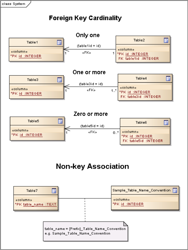
In this standard, the following two stereotypes of UML classes are used to represent RDBMS tables:
-
<<table>> An instantiation of a UML class as an RDMBS table.
-
<<column>> An instantiation of a UML attribute as an RDBMS table column.
In this standard, the following standard data types are used for RDBMS columns:
-
NULL – The value is a NULL value.
-
INTEGER – A signed integer, stored in 1, 2, 3, 4, 6, or 8 bytes depending on the magnitude of the value
-
REAL – The value is a floating point value, stored as an 8-byte IEEE floating point number.
-
TEXT – A sequence of characters, stored using the database encoding (UTF-8, UTF-16BE or UTF-16LE).
-
BLOB – The value is a blob of data, stored exactly as it was input.
-
NONE – The value is a Date / Time Timestamp
B.11. GeoPackage Tables Detailed Diagram
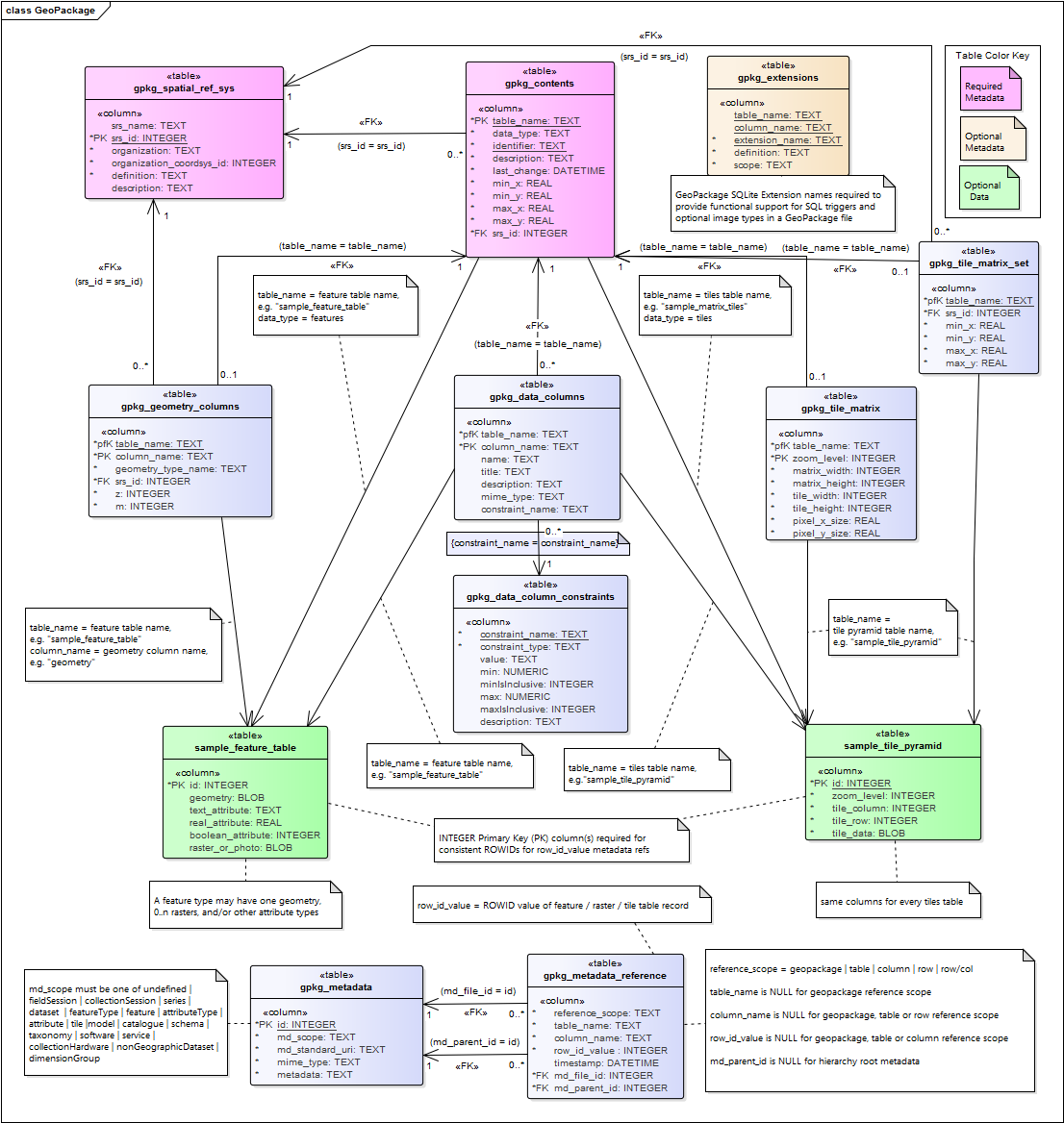
B.12. GeoPackage Minimal Tables for Features Diagram
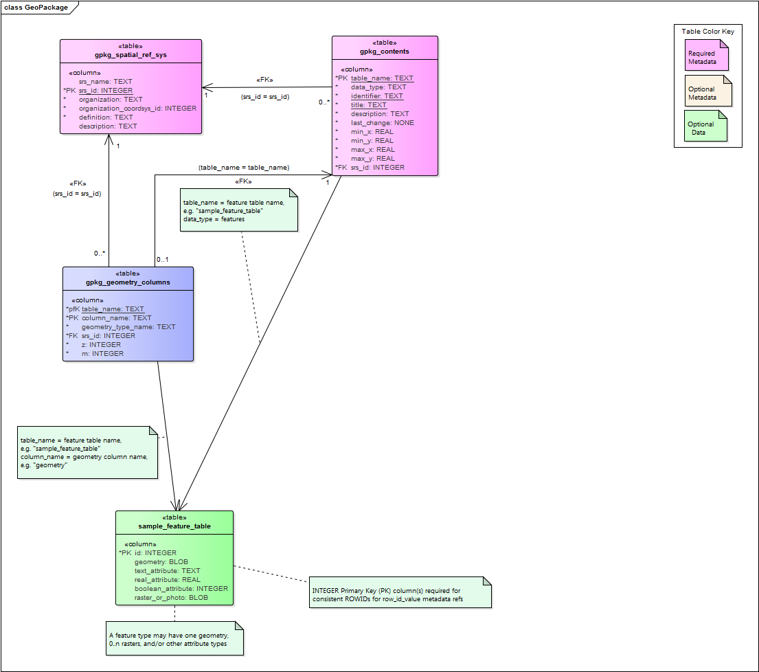
B.13. GeoPackage Minimal Tables for Tiles Diagram
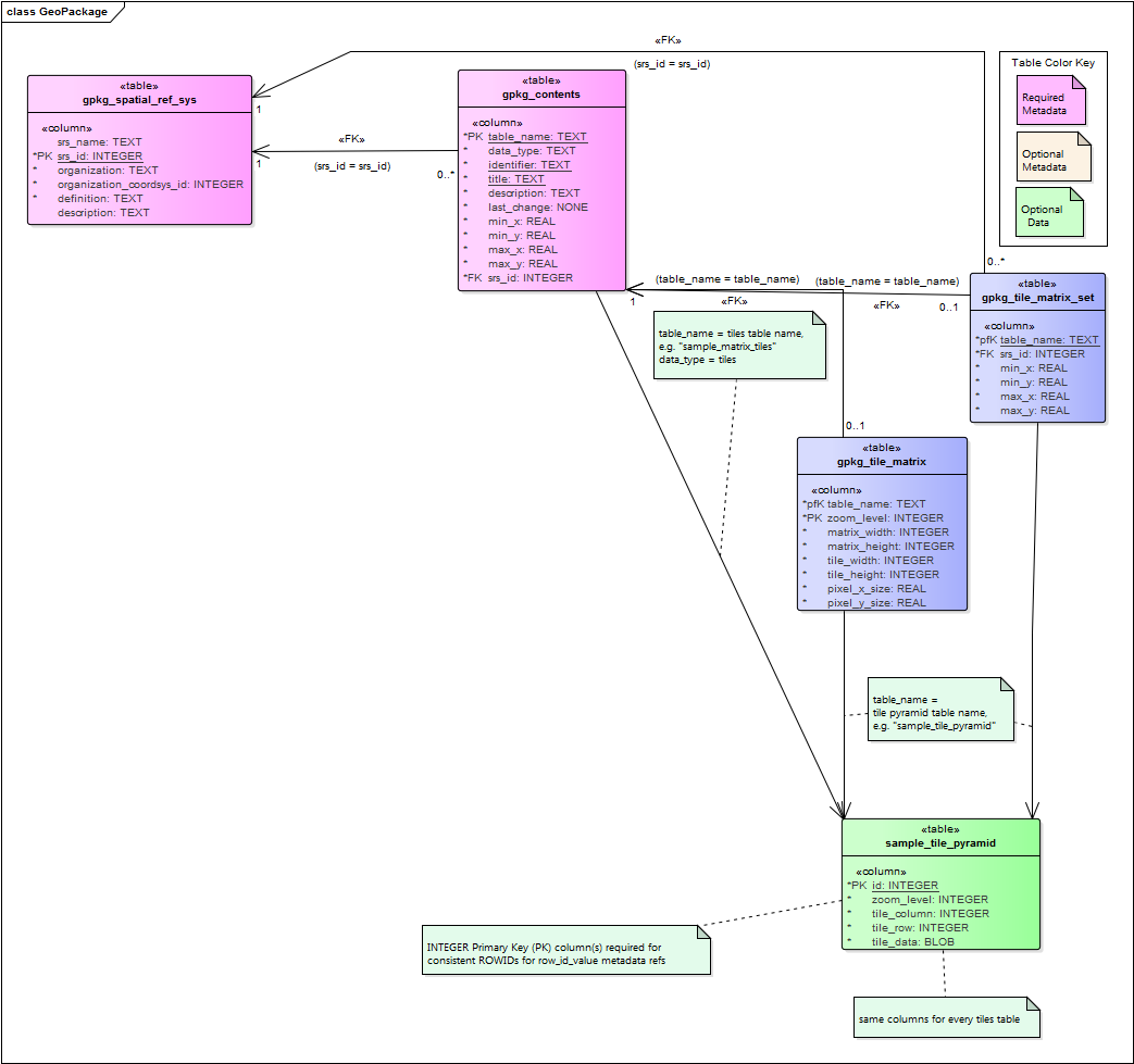
Annex C: Table Definition SQL (Normative)
C.1. gpkg_spatial_ref_sys
CREATE TABLE gpkg_spatial_ref_sys (
  srs_name TEXT NOT NULL,
  srs_id INTEGER NOT NULL PRIMARY KEY,
  organization TEXT NOT NULL,
  organization_coordsys_id INTEGER NOT NULL,
  definition  TEXT NOT NULL,
  description TEXT
);CREATE VIEW st_spatial_ref_sys AS
SELECT
srs_name,
srs_id,
organization,
organization_coordsys_id,
definition,
description
FROM gpkg_spatial_ref_sys;CREATE VIEW spatial_ref_sys AS
SELECT
srs_id AS srid,
organization AS auth_name,
organization_coordsys_id AS auth_srid,
definition AS srtext
FROM gpkg_spatial_ref_sys;C.2. gpkg_contents
CREATE TABLE gpkg_contents (
  table_name TEXT NOT NULL PRIMARY KEY,
  data_type TEXT NOT NULL,
  identifier TEXT UNIQUE,
  description TEXT DEFAULT '',
  last_change DATETIME NOT NULL DEFAULT (strftime('%Y-%m-%dT%H:%M:%fZ','now')),
  min_x DOUBLE,
  min_y DOUBLE,
  max_x DOUBLE,
  max_y DOUBLE,
  srs_id INTEGER,
  CONSTRAINT fk_gc_r_srs_id FOREIGN KEY (srs_id) REFERENCES gpkg_spatial_ref_sys(srs_id)
);
C.3. gpkg_geometry_columns
CREATE TABLE gpkg_geometry_columns (
  table_name TEXT NOT NULL,
  column_name TEXT NOT NULL,
  geometry_type_name TEXT NOT NULL,
  srs_id INTEGER NOT NULL,
  z TINYINT NOT NULL,
  m TINYINT NOT NULL,
  CONSTRAINT pk_geom_cols PRIMARY KEY (table_name, column_name),
  CONSTRAINT uk_gc_table_name UNIQUE (table_name),
  CONSTRAINT fk_gc_tn FOREIGN KEY (table_name) REFERENCES gpkg_contents(table_name),
  CONSTRAINT fk_gc_srs FOREIGN KEY (srs_id) REFERENCES gpkg_spatial_ref_sys (srs_id)
);CREATE VIEW st_geometry_columns AS
SELECT
table_name,
column_name,
"ST_" || geometry_type_name,
g.srs_id,
srs_name
FROM gpkg_geometry_columns as g JOIN gpkg_spatial_ref_sys AS s
WHERE g.srs_id = s.srs_id;CREATE VIEW geometry_columns AS
SELECT
table_name AS f_table_name,
column_name AS f_geometry_column,
code4name (geometry_type_name) AS geometry_type,
2 + (CASE z WHEN 1 THEN 1 WHEN 2 THEN 1 ELSE 0 END) + (CASE m WHEN 1 THEN 1 WHEN 2 THEN 1 ELSE 0 END) AS coord_dimension,
srs_id AS srid
FROM gpkg_geometry_columns;| Implementer must provide code4name(geometry_type_name) SQL function |
C.4. sample_feature_table (Informative)
CREATE TABLE sample_feature_table (
  id INTEGER PRIMARY KEY AUTOINCREMENT NOT NULL,
  geometry GEOMETRY,
  text_attribute TEXT,
  real_attribute REAL,
  boolean_attribute BOOLEAN,
  raster_or_photo BLOB
);
C.5. gpkg_tile_matrix_set
CREATE TABLE gpkg_tile_matrix_set (
  table_name TEXT NOT NULL PRIMARY KEY,
  srs_id INTEGER NOT NULL,
  min_x DOUBLE NOT NULL,
  min_y DOUBLE NOT NULL,
  max_x DOUBLE NOT NULL,
  max_y DOUBLE NOT NULL,
  CONSTRAINT fk_gtms_table_name FOREIGN KEY (table_name) REFERENCES gpkg_contents(table_name),
  CONSTRAINT fk_gtms_srs FOREIGN KEY (srs_id) REFERENCES gpkg_spatial_ref_sys (srs_id)
);
C.6. gpkg_tile_matrix
CREATE TABLE gpkg_tile_matrix (
  table_name TEXT NOT NULL,
  zoom_level INTEGER NOT NULL,
  matrix_width INTEGER NOT NULL,
  matrix_height INTEGER NOT NULL,
  tile_width INTEGER NOT NULL,
  tile_height INTEGER NOT NULL,
  pixel_x_size DOUBLE NOT NULL,
  pixel_y_size DOUBLE NOT NULL,
  CONSTRAINT pk_ttm PRIMARY KEY (table_name, zoom_level),
  CONSTRAINT fk_tmm_table_name FOREIGN KEY (table_name) REFERENCES gpkg_contents(table_name)
);INSERT INTO gpkg_tile_matrix VALUES (
"sample_tile_pyramid",
0,
1,
1,
512,
512,
2.0,
2.0
);C.7. sample_tile_pyramid (Informative)
CREATE TABLE sample_tile_pyramid (
  id INTEGER PRIMARY KEY AUTOINCREMENT NOT NULL,
  zoom_level INTEGER NOT NULL,
  tile_column INTEGER NOT NULL,
  tile_row INTEGER NOT NULL,
  tile_data BLOB NOT NULL,
  UNIQUE (zoom_level, tile_column, tile_row)
)INSERT INTO sample_matrix_pyramid VALUES (
1,
1,
1,
1,
"BLOB VALUE"
)C.8. gpkg_extensions
CREATE TABLE gpkg_extensions (
  table_name TEXT,
  column_name TEXT,
  extension_name TEXT NOT NULL,
  definition TEXT NOT NULL,
  scope TEXT NOT NULL,
  CONSTRAINT ge_tce UNIQUE (table_name, column_name, extension_name)
);
C.9. sample_attributes_table (Informative)
CREATE TABLE sample_attributes (
  id INTEGER PRIMARY KEY AUTOINCREMENT NOT NULL,
  text_attribute TEXT,
  real_attribute REAL,
  boolean_attribute BOOLEAN,
  raster_or_photo BLOB
)INSERT INTO sample_attributes(text_attribute, real_attribute, boolean_attribute, raster_or_photo) VALUES (
"place",
1,
true,
"BLOB VALUE"
)Annex D: Trigger Definition SQL (Informative)
D.1. gpkg_tile_matrix
CREATE TRIGGER 'gpkg_tile_matrix_zoom_level_insert'
BEFORE INSERT ON 'gpkg_tile_matrix'
FOR EACH ROW BEGIN
SELECT RAISE(ABORT, 'insert on table ''gpkg_tile_matrix'' violates constraint: zoom_level cannot be less than 0')
WHERE (NEW.zoom_level < 0);
END

CREATE TRIGGER 'gpkg_tile_matrix_zoom_level_update'
BEFORE UPDATE of zoom_level ON 'gpkg_tile_matrix'
FOR EACH ROW BEGIN
SELECT RAISE(ABORT, 'update on table ''gpkg_tile_matrix'' violates constraint: zoom_level cannot be less than 0')
WHERE (NEW.zoom_level < 0);
END

CREATE TRIGGER 'gpkg_tile_matrix_matrix_width_insert'
BEFORE INSERT ON 'gpkg_tile_matrix'
FOR EACH ROW BEGIN
SELECT RAISE(ABORT, 'insert on table ''gpkg_tile_matrix'' violates constraint: matrix_width cannot be less than 1')
WHERE (NEW.matrix_width < 1);
END

CREATE TRIGGER 'gpkg_tile_matrix_matrix_width_update'
BEFORE UPDATE OF matrix_width ON 'gpkg_tile_matrix'
FOR EACH ROW BEGIN
SELECT RAISE(ABORT, 'update on table ''gpkg_tile_matrix'' violates constraint: matrix_width cannot be less than 1')
WHERE (NEW.matrix_width < 1);
END

CREATE TRIGGER 'gpkg_tile_matrix_matrix_height_insert'
BEFORE INSERT ON 'gpkg_tile_matrix'
FOR EACH ROW BEGIN
SELECT RAISE(ABORT, 'insert on table ''gpkg_tile_matrix'' violates constraint: matrix_height cannot be less than 1')
WHERE (NEW.matrix_height < 1);
END

CREATE TRIGGER 'gpkg_tile_matrix_matrix_height_update'
BEFORE UPDATE OF matrix_height ON 'gpkg_tile_matrix'
FOR EACH ROW BEGIN
SELECT RAISE(ABORT, 'update on table ''gpkg_tile_matrix'' violates constraint: matrix_height cannot be less than 1')
WHERE (NEW.matrix_height < 1);
END

CREATE TRIGGER 'gpkg_tile_matrix_pixel_x_size_insert'
BEFORE INSERT ON 'gpkg_tile_matrix'
FOR EACH ROW BEGIN
SELECT RAISE(ABORT, 'insert on table ''gpkg_tile_matrix'' violates constraint: pixel_x_size must be greater than 0')
WHERE NOT (NEW.pixel_x_size > 0);
END

CREATE TRIGGER 'gpkg_tile_matrix_pixel_x_size_update'
BEFORE UPDATE OF pixel_x_size ON 'gpkg_tile_matrix'
FOR EACH ROW BEGIN
SELECT RAISE(ABORT, 'update on table ''gpkg_tile_matrix'' violates constraint: pixel_x_size must be greater than 0')
WHERE NOT (NEW.pixel_x_size > 0);
END

CREATE TRIGGER 'gpkg_tile_matrix_pixel_y_size_insert'
BEFORE INSERT ON 'gpkg_tile_matrix'
FOR EACH ROW BEGIN
SELECT RAISE(ABORT, 'insert on table ''gpkg_tile_matrix'' violates constraint: pixel_y_size must be greater than 0')
WHERE NOT (NEW.pixel_y_size > 0);
END

CREATE TRIGGER 'gpkg_tile_matrix_pixel_y_size_update'
BEFORE UPDATE OF pixel_y_size ON 'gpkg_tile_matrix'
FOR EACH ROW BEGIN
SELECT RAISE(ABORT, 'update on table ''gpkg_tile_matrix'' violates constraint: pixel_y_size must be greater than 0')
WHERE NOT (NEW.pixel_y_size > 0);
END
D.2. sample_feature_table
CREATE TRIGGER "sample_feature_table_real_insert"
BEFORE INSERT ON "sample_feature_table"
FOR EACH ROW BEGIN
SELECT RAISE(ABORT, 'insert on table ''sample_feature_table''
violates constraint: real_attribute must be greater than 0')
WHERE NOT (NEW.real_attribute > 0);
END

CREATE TRIGGER "sample_feature_table_real_update"
BEFORE UPDATE OF "real_attribute" ON "sample_feature_table"
FOR EACH ROW BEGIN
SELECT RAISE (ABORT, 'update of ''real_attribute'' on table
''sample_feature_table'' violates constraint: real_attribute value
must be > 0')
WHERE NOT (NEW.real_attribute > 0);
END
where <t> and <c> are replaced with the names of the feature table and geometry column being inserted or updated.
D.3. sample_tile_pyramid
CREATE TRIGGER "sample_tile_pyramid_zoom_insert"
BEFORE INSERT ON "sample_tile_pyramid"
FOR EACH ROW BEGIN
SELECT RAISE(ABORT, 'insert on table ''sample_tile_pyramid'' violates constraint: zoom_level not specified for table in gpkg_tile_matrix')
WHERE NOT (NEW.zoom_level IN (SELECT zoom_level FROM gpkg_tile_matrix WHERE table_name = 'sample_tile_pyramid')) ;
END

CREATE TRIGGER "sample_tile_pyramid_zoom_update"
BEFORE UPDATE OF zoom_level ON "sample_tile_pyramid"
FOR EACH ROW BEGIN
SELECT RAISE(ABORT, 'update on table ''sample_tile_pyramid'' violates constraint: zoom_level not specified for table in gpkg_tile_matrix')
WHERE NOT (NEW.zoom_level IN (SELECT zoom_level FROM gpkg_tile_matrix WHERE table_name = 'sample_tile_pyramid')) ;
END

CREATE TRIGGER "sample_tile_pyramid_tile_column_insert"
BEFORE INSERT ON "sample_tile_pyramid"
FOR EACH ROW BEGIN
SELECT RAISE(ABORT, 'insert on table ''sample_tile_pyramid'' violates constraint: tile_column cannot be < 0')
WHERE (NEW.tile_column < 0) ;
SELECT RAISE(ABORT, 'insert on table ''sample_tile_pyramid'' violates constraint: tile_column must by < matrix_width specified for table and zoom level in gpkg_tile_matrix')
WHERE NOT (NEW.tile_column < (SELECT matrix_width FROM gpkg_tile_matrix WHERE table_name = 'sample_tile_pyramid' AND zoom_level = NEW.zoom_level));
END

CREATE TRIGGER "sample_tile_pyramid_tile_column_update"
BEFORE UPDATE OF tile_column ON "sample_tile_pyramid"
FOR EACH ROW BEGIN
SELECT RAISE(ABORT, 'update on table ''sample_tile_pyramid'' violates constraint: tile_column cannot be < 0')
WHERE (NEW.tile_column < 0) ;
SELECT RAISE(ABORT, 'update on table ''sample_tile_pyramid'' violates constraint: tile_column must by < matrix_width specified for table and zoom level in gpkg_tile_matrix')
WHERE NOT (NEW.tile_column < (SELECT matrix_width FROM gpkg_tile_matrix WHERE table_name = 'sample_tile_pyramid' AND zoom_level = NEW.zoom_level));
END

CREATE TRIGGER "sample_tile_pyramid_tile_row_insert"
BEFORE INSERT ON "sample_tile_pyramid"
FOR EACH ROW BEGIN
SELECT RAISE(ABORT, 'insert on table ''sample_tile_pyramid'' violates constraint: tile_row cannot be < 0')
WHERE (NEW.tile_row < 0) ;
SELECT RAISE(ABORT, 'insert on table ''sample_tile_pyramid'' violates constraint: tile_row must by < matrix_height specified for table and zoom level in gpkg_tile_matrix')
WHERE NOT (NEW.tile_row < (SELECT matrix_height FROM gpkg_tile_matrix WHERE table_name = 'sample_tile_pyramid' AND zoom_level = NEW.zoom_level));
END

CREATE TRIGGER "sample_tile_pyramid_tile_row_update"
BEFORE UPDATE OF tile_row ON "sample_tile_pyramid"
FOR EACH ROW BEGIN
SELECT RAISE(ABORT, 'update on table ''sample_tile_pyramid'' violates constraint: tile_row cannot be < 0')
WHERE (NEW.tile_row < 0) ;
SELECT RAISE(ABORT, 'update on table ''sample_tile_pyramid'' violates constraint: tile_row must by < matrix_height specified for table and zoom level in gpkg_tile_matrix')
WHERE NOT (NEW.tile_row < (SELECT matrix_height FROM gpkg_tile_matrix WHERE table_name = 'sample_tile_pyramid' AND zoom_level = NEW.zoom_level));
END
Annex E: GeoPackage Extension Template (Informative)
Extension Title
Title of the Extension
Introduction
Description of extension
Extension Author
Author of extension, author_name.
Extension Name or Template
Name of the extension or definition of the template to create the name of extensions that should be used in gpkg_extensions
Extension Type
"Extension of Existing Requirement in Clause(s) XXX" or "New Requirement Dependent on Clause(s) YYY"
Applicability
Tables and/or columns on which this extension may be applied
Scope
Read-write or write-only with clarification if necessary
Requirements
Definition of extension and interdependencies with other extensions if any.
GeoPackage
Definition of extension data or MIME type(s)
Definition of extension tables or table templates
Definition of triggers or trigger templates
GeoPackage SQLite Configuration
Definition of SQLite configuration settings
| Setting compile or runtime | Option | Shall / Not (Value) | Discussion |
|---|---|---|---|
GeoPackage SQLite Extension
Definition of SQL functions
| SQL Function | Description | Use |
|---|---|---|
foo(bar, baz) : datatype |
Returns r when w |
Abstract Test Suite
All test cases required to verify conformance to this extension.
Examples (Informative)
Any example or samples demonstrating the extension in use.
Annex F: Registered Extensions (Normative)
This clause specifies requirements for GeoPackage extensions. Definitions of those extensions are in the form specified by the template in GeoPackage Extension Template (Informative).
| Extension Name | Content Type |
|---|---|
features |
|
features |
|
tiles |
|
tiles |
|
general |
|
features |
|
spatial reference systems |
F.1. GeoPackage Non-Linear Geometry Types
Introduction
This extension of clause SQL Geometry Types defines additional geometry types.
Clause 2.1.4 of the GeoPackage Version 1 Encoding Standard specifies support for the Geometry, Point, LineString, Polygon, MultiPoint, MultiLineString, MultiPolygon, and GeomCollection geometry types in the GeoPackageBinary geometry encoding format specified in clause 2.1.3. This extension specifies support for the additional CircularString, CompoundCurve, CurvePolygon, MultiCurve, MultiSurface, Curve, and Surface geometry types in the GeoPackage Binary geometry encoding format using the codes from Geometry Type Codes (Extension).
Extension Author
GeoPackage SWG, author_name gpkg
Extension Name or Template
Extension names are constructed from the gpkg_geom_<gname> template where <gname> is the uppercase name of the extension geometry type from Geometry Type Codes (Extension).
Extension Type
Extension of Existing Requirement in clause SQL Geometry Types
Applicability
This extension applies to any column specified in the gpkg_geometry_columns table.
Scope
Read-write
Requirements
GeoPackage
(extends GPKG-25) The geometry_type_name value in a gpkg_geometry_columns row MAY be one of the uppercase extended non-linear geometry type names specified in Geometry Types (Normative).
The GeoPackageBinary geometry encoding format specified in clause Geometry Encoding SHALL be used to encode non-linear geometry types using the type codes in Geometry Types (Normative) table Geometry Type Codes (Extension).
An extension name to specify a feature geometry extension type SHALL be defined for the "gpkg" author name using the "gpkg_geom_<gname>" template where <gname> is the uppercase name of the extension geometry type from Geometry Types (Normative) used in a GeoPackage.
A GeoPackage that contains a gpkg_geometry_columns table or updateable view with row records that specify extension geometry_type_name column values SHALL contain a gpkg_extensions table that contains row records with table_name and column_name values from the gpkg_geometry_columns row records that identify extension type uses, and extension_name column values for each of those geometry types constructed per the previous requirement [extension_geometry_types_extensions_name].
GeoPackage SQLite Configuration
None
GeoPackage SQLite Extension
SQL functions that operate on GeoPackageBinary geometries as specified in other extensions SHALL operate correctly on the non-linear geometries specified in this extension.
Abstract Test Suite
GeoPackage Extension Types
Test Case ID |
|
Test Purpose |
Verify that only allowed geometry types (including extended non-linear geometry types) are in use. |
Test Method |
|
Reference |
Annex F.1 Req 65: |
Test Type |
Capability |
Test Case ID |
|
Test Purpose |
Verify that geometries non-linear geometry types are stored in valid GeoPackageBinary format encodings. |
Test Method |
|
Reference |
Annex F.1 Req 66: |
Test Type |
Capability |
Extensions Name
Test Case ID |
|
Test Purpose |
Verify that an extension name in the form gpkg_geom_<gname> is defined for each <gname> extension geometry type from Annex G used in a GeoPackage. |
Test Method |
|
Reference |
Annex F.1 Req 67: |
Test Type |
Basic |
Extensions Row
Test Case ID |
|
Test Purpose |
Verify that the gpkg_extensions table contains a row with an extension_name in the form gpkg_geom_<gname> for each table_name and column_name in the gpkg_geometry_columns table with a <gname> geometry_type_name. |
Test Method |
|
Reference |
Annex F.1 Req 68: |
Test Type |
Capability |
F.2. User Defined Geometry Types Extension of GeoPackageBinary Geometry Encoding
|
On August 15, 2016 the GeoPackage SWG voted to remove this extension from the standard due to interoperability concerns. For more information see the release notes. |
F.3. RTree Spatial Indexes
Introduction
This extension adds a new capability for spatially indexing columns with geometries encoded per clause Geometry Encoding and User Defined Geometry Types Extension of GeoPackageBinary Geometry Encoding.
The RTree index extension provides a means to encode an RTree index for geometry values in a GeoPackage. An RTree index provides a significant performance advantage for searches with basic envelope spatial criteria that return subsets of the rows in a feature table with a non-trivial number (thousands or more) of rows.
Spatial indexes provide a significant performance advantage for searches with basic envelope spatial criteria that return subsets of the rows in a feature table with a non-trivial number (thousands or more) of rows.[K26]
Extension Author
GeoPackage SWG, author_name gpkg.
Extension Name or Template
gpkg_rtree_index
Extension Type
New Requirement dependent on clauses Geometry Encoding and User Defined Geometry Types Extension of GeoPackageBinary Geometry Encoding.
Applicability
This extension applies to any column specified in the gpkg_geometry_columns table.
Scope
Write-only, because it does not change the result of reads, although it may improve their performance.
Requirements
This extension uses the rtree implementation provided by the SQLite R*Tree Module extension documented at http://www.sqlite.org/rtree.html.
GeoPackage
The "gpkg_rtree_index" extension name SHALL be used as a gpkg_extensions table extension_name column value to specify implementation of spatial indexes on a geometry column.
A GeoPackage that implements spatial indexes SHALL have a gpkg_extensions table that contains a row for each spatially indexed column with extension_name "gpkg_rtree_index", the table_name of the table with a spatially indexed column, the column_name of the spatially indexed column, and a scope of "write-only".
A GeoPackage SHALL implement spatial indexes on feature table geometry columns using the SQLite Virtual Table RTrees and triggers specified below.
The tables below contain SQL templates with variables.
Replace the following template variables with the specified values to create the required SQL statements:
<t>: The name of the feature table containing the geometry column
<c>: The name of the geometry column in <t> that is being indexed
<i>: The name of the integer primary key column in <t> as specified in Requirement 29
Create Virtual Table
RTree spatial indexes on geometry columns SHALL be created using the SQLite Virtual Table RTree extension. An application that creates a spatial index SHALL create it using the following SQL statement template:
CREATE VIRTUAL TABLE rtree_<t>_<c> USING rtree(id, minx, maxx, miny, maxy)where <t> and <c> are replaced with the names of the feature table and geometry column being indexed. The rtree function id parameter becomes the virtual table 64-bit signed integer primary key id column, and the min/max x/y parameters are min- and max-value pairs (stored as 32-bit floating point numbers) for each dimension that become the virtual table data columns that are populated to create the spatial rtree index.
Load Spatial Index Values
The indexes provided by the SQLite Virtual Table RTree extension are not automatic indices. This means the index data structure needs to be manually populated, updated and queried. Each newly created spatial index SHALL be populated using the following SQL statement
INSERT OR REPLACE INTO rtree_<t>_<c>
  SELECT <i>, st_minx(<c>), st_maxx(<c>), st_miny(<c>), st_maxy(<c>) FROM <t>;
where <t> and <c> are replaced with the names of the feature table and geometry column being indexed and <i> is replaced with the name of the feature table integer primary key column.
Define Triggers to Maintain Spatial Index Values
For each spatial index in a GeoPackage, corresponding insert, update and delete triggers that update the spatial index SHALL be present on the indexed geometry column. These spatial index triggers SHALL be defined as follows:
/* Conditions: Insertion of non-empty geometry
   Actions   : Insert record into rtree */
CREATE TRIGGER rtree_<t>_<c>_insert AFTER INSERT ON <t>
  WHEN (new.<c> NOT NULL AND NOT ST_IsEmpty(NEW.<c>))
BEGIN
  INSERT OR REPLACE INTO rtree_<t>_<c> VALUES (
    NEW.<i>,
    ST_MinX(NEW.<c>), ST_MaxX(NEW.<c>),
    ST_MinY(NEW.<c>), ST_MaxY(NEW.<c>)
  );
END;

/* Conditions: Update of geometry column to non-empty geometry
               No row ID change
   Actions   : Update record in rtree */
CREATE TRIGGER rtree_<t>_<c>_update1 AFTER UPDATE OF <c> ON <t>
  WHEN OLD.<i> = NEW.<i> AND
       (NEW.<c> NOTNULL AND NOT ST_IsEmpty(NEW.<c>))
BEGIN
  INSERT OR REPLACE INTO rtree_<t>_<c> VALUES (
    NEW.<i>,
    ST_MinX(NEW.<c>), ST_MaxX(NEW.<c>),
    ST_MinY(NEW.<c>), ST_MaxY(NEW.<c>)
  );
END;

/* Conditions: Update of geometry column to empty geometry
               No row ID change
   Actions   : Remove record from rtree */
CREATE TRIGGER rtree_<t>_<c>_update2 AFTER UPDATE OF <c> ON <t>
  WHEN OLD.<i> = NEW.<i> AND
       (NEW.<c> ISNULL OR ST_IsEmpty(NEW.<c>))
BEGIN
  DELETE FROM rtree_<t>_<c> WHERE id = OLD.<i>;
END;

/* Conditions: Update of any column
               Row ID change
               Non-empty geometry
   Actions   : Remove record from rtree for old <i>
               Insert record into rtree for new <i> */
CREATE TRIGGER rtree_<t>_<c>_update3 AFTER UPDATE OF <c> ON <t>
  WHEN OLD.<i> != NEW.<i> AND
       (NEW.<c> NOTNULL AND NOT ST_IsEmpty(NEW.<c>))
BEGIN
  DELETE FROM rtree_<t>_<c> WHERE id = OLD.<i>;
  INSERT OR REPLACE INTO rtree_<t>_<c> VALUES (
    NEW.<i>,
    ST_MinX(NEW.<c>), ST_MaxX(NEW.<c>),
    ST_MinY(NEW.<c>), ST_MaxY(NEW.<c>)
  );
END;

/* Conditions: Update of any column
               Row ID change
               Empty geometry
   Actions   : Remove record from rtree for old and new <i> */
CREATE TRIGGER rtree_<t>_<c>_update4 AFTER UPDATE ON <t>
  WHEN OLD.<i> != NEW.<i> AND
       (NEW.<c> ISNULL OR ST_IsEmpty(NEW.<c>))
BEGIN
  DELETE FROM rtree_<t>_<c> WHERE id IN (OLD.<i>, NEW.<i>);
END;

/* Conditions: Row deleted
   Actions   : Remove record from rtree for old <i> */
CREATE TRIGGER rtree_<t>_<c>_delete AFTER DELETE ON <t>
  WHEN old.<c> NOT NULL
BEGIN
  DELETE FROM rtree_<t>_<c> WHERE id = OLD.<i>;
END;
where <t> and <c> are replaced with the names of the feature table and geometry column being indexed and <i> is replaced with the name of the feature table integer primary key column.
GeoPackage SQLite Configuration
Definition of SQLite configuration settings
| Setting compile or runtime | Option | Shall / Not (Value) | Discussion |
|---|---|---|---|
compile |
SQLITE_ENABLE_RTREE |
Shall |
RTrees ares used for GeoPackage Spatial Indexes |
compile |
SQLITE_RTREE_INT_ONLY |
Not |
RTrees with floating point values are used for GeoPackage spatial indexes |
GeoPackage SQLite Extension
Definition of SQL functions
| SQL Function | Description | Use |
|---|---|---|
ST_IsEmpty(geom Geometry): integer |
Returns 1 if geometry value is empty, 0 if not empty, NULL if geometry value is NULL |
Test if a geometry value corresponds to the empty set |
ST_MinX(geom Geometry): real |
Returns the minimum X value of the bounding envelope of a geometry |
Update the spatial index on a geometry column in a feature table |
ST_MaxX(geom Geometry): real |
Returns the maximum Y value of the bounding envelope of a geometry |
Update the spatial index on a geometry column in a feature table |
ST_MinY(geom Geometry): real |
Returns the minimum X value of the bounding envelope of a geometry |
Update the spatial index on a geometry column in a feature table |
ST_MaxY(geom Geometry): real |
Returns the maximum Y value of the bounding envelope of a geometry |
Update the spatial index on a geometry column in a feature table |
The SQL functions on geometries in this SQLite Extension SHALL operate correctly on extended geometry types specified by User Defined Geometry Types Extension of GeoPackageBinary Geometry Encoding and/or GeoPackage Non-Linear Geometry Types when those extensions are also implemented.
Abstract Test Suite
Extension Name
Test Case ID |
|
Test Purpose |
Verify that spatial index extensions are registered using the "gpkg_rtree_index" name in the gpkg_extensions table. |
Test Method |
|
Reference |
Annex F.3 Req 75 |
Test Type |
Capability |
Extensions Row
Test Case ID |
|
Test Purpose |
Verify that the "gpkg_rtree_index" extension name is used to register spatial index extensions. |
Test Method |
|
Reference |
Annex F.3 Req 76 |
Test Type |
Basic |
Implementation
Test Case ID |
|
Test Purpose |
Verify the correct implementation of spatial indexes on feature table geometry columns. |
Test Method |
|
Reference |
Annex F.3 Req 77 |
Test Type |
Capability |
Test Case ID |
|
Test Purpose |
Verify the correct implementation of sql functions used in spatial indexes on feature table geometry columns. |
Test Method |
|
Reference |
Annex F.3 Req 78 |
Test Type |
Capability |
F.4. Geometry Type Triggers
|
On August 15, 2016 the GeoPackage SWG voted to remote this extension from the standard due to interoperability concerns. For more information see the release notes. |
F.5. Geometry SRS ID Triggers
|
On August 15, 2016 the GeoPackage SWG voted to remote this extension from the standard due to interoperability concerns. For more information see the release notes. |
F.6. Zoom Other Intervals
Introduction
This extension of clause Zoom Levels allows zoom level intervals other than a factor of two.
In a GeoPackage, zoom levels are integers in sequence from 0 to n that identify tile matrix layers in a tile matrix set that contain tiles of decreasing spatial extent and finer spatial resolution. Adjacent zoom levels immediately precede or follow each other and differ by a value of 1. Pixel sizes are real numbers in the terrain units of the spatial reference system of a tile image specifying the dimensions of the real world area represented by one pixel. Pixel sizes MAY vary by a constant factor or by different factors or intervals between some or all adjacent zoom levels in a tile matrix set. In the commonly used "zoom times two" convention, pixel sizes vary by a factor of 2 between all adjacent zoom levels, as shown in the example in [tiles_factor2_example_appendix].
This extension enables use of "zoom other intervals" conventions with different factors or irregular intervals with pixel sizes chosen for intuitive cartographic representation of raster data, or to coincide with the original pixel size of commonly used global image products. See WMTS [16] Annex E for additional examples of both conventions.
Extension Author
GeoPackage SWG, author_name gpkg
Extension Name or Template
gpkg_zoom_other
Extension Type
Extension of Existing Requirement in clause 2.2.3.
Applicability
This extension applies to any table listed in the gpkg_contents table with a data_type of tiles.
Scope
Read-write
Requirements
GeoPackage
The "gpkg_zoom_other" extension name SHALL be used as a gpkg_extensions table extension name column value to specify implementation of other zoom intervals on a tile pyramid user data table as specified in Zoom Other Intervals.
A GeoPackage that implements other zoom intervals SHALL have a gpkg_extensions table that contains a row for each tile pyramid user data table with other zoom intervals with extension_name "gpkg_zoom_other", the table_name of the table with other zoom intervals, and the "tile_data" column_name.
Tile pyramid user data tables MAY have pixel sizes that vary by irregular intervals or by regular intervals other than a factor of two (the default) between adjacent zoom levels. Extends Requirement 35.
The pixel_x_size and / or pixel_y_size column values in the gpkg_tile_matrix table vary by irregular intervals or by regular intervals other than a factor of two (the default) between adjacent zoom levels for a particular tile matrix set pyramid table.
GeoPackage SQLite Configuration
None
GeoPackage SQLite Extension
None
Abstract Test Suite
Extensions Name
Test Case ID |
|
Test Purpose |
Verify that the "gpkg_zoom_other" extension name is used to register tiles tables with other than factors of two zoom intervals. |
Test Method |
|
Reference |
Annex F.6 Req 87 |
Test Type |
Basic |
Extensions Row
Test Case ID |
|
Test Purpose |
Verify that tiles tables with other than factors of two zoom intervals are registered using the "gpkg_zoom_other" extension name. |
Test Method |
/reg_ext/tiles/zoom_levels/data/zoom_other_ext_name |
Reference |
Annex F.6 Req 88 |
Test Type: |
Capability |
Zoom Interval
Test Case ID |
|
Test Purpose |
Verify that zoom level pixel sizes for tile matrix user data tables vary by factors of 2 between adjacent zoom levels in the tile matrix metadata table only for tile matrix sets that this extension does not apply to. |
Test Method |
|
Reference |
Annex F.6 Req 89 |
Test Type |
Capability |
F.7. Tiles Encoding WebP
Introduction
This extension of clauses Tile Encoding PNG and Tile Encoding JPEG allows encoding of tile images in WebP format.
PNG and JPEG are the default MIME types for encoding images in tile pyramid user data tables.
This extension allows the use of image/x-webp as an additional encoding type.
Extension Author
GeoPackage SWG, author_name gpkg.
Extension Name or Template
gpkg_webp
Extension Type
Extension of Existing Requirement in clauses Tile Encoding PNG and Tile Encoding JPEG.
Applicability
This extension applies to any table listed in the gpkg_contents table with a data_type of tiles.
Scope
Read-write
Requirements
GeoPackage
GeoPackages with one or more rows in the gpkg_extensions table with an extension_name of "gpkg_webp" SHALL comply with this extension.
A GeoPackage that contains tile pyramid user data tables with tile_data columns that contain images in WebP format SHALL contain a gpkg_extensions table that contains row records with table_name values for each such table, column_name values of "tile_data", extension_name column values of "gpkg_webp", and scope column values of "read-write".
| Requirements 36 and 37 allow a tile pyramid user data table to contain PNG or JPG tiles. This requirement allows for WebP tiles as well. |
GeoPackage SQLite Configuration
None
GeoPackage SQLite Extension
None
Abstract Test Suite
Extensions Name
Test Case ID |
|
Test Purpose: |
Verify that the "gpkg_webp" extensions name is used to register WEBP tile encoding implementations. |
Test Method: |
|
Reference |
Annex F.7 Req 90 |
Test Type |
Basic |
Extensions Row
Test Case ID |
|
Test Purpose: |
Verify that this extension is registered using proper rows in the |
Test Method: |
|
Reference: |
Annex F.7 Req 91 |
Test Type |
Capability |
Extensions Mime Type
Test Case ID |
|
Test Purpose |
Verify that a tile matrix user data table that conforms to this extension contains a valid image type, including images of MIME type image/x-webp. |
Test Method |
|
Reference |
Annex F.7 Req 92 |
Test Type |
Capability |
F.8. Metadata
Introduction
Two tables in a GeoPackage provide a means of storing metadata in MIME [21] encodings that are defined in accordance with any authoritative metadata specifications, and relating it to the features, rasters, and tiles data in a GeoPackage. These tables are intended to provide the support necessary to implement the hierarchical metadata models as defined in ISO 19115 [28] and illustrated in Hierarchical Metadata Example One - ISO19115. and Raster or Tile Metadata Example. As GeoPackage data is captured and updated, the most local and specific detailed metadata changes associated with the new or modified data MAY be captured separately, and referenced to existing global and general metadata.
The gpkg_metadata table that contains metadata is described in clause Metadata Table, and the gpkg_metadata_reference table that relates gpkg_metadata to GeoPackage data is described in clause Metadata Reference Table.
There is no GeoPackage requirement that such metadata be provided or that defined metadata be structured in a hierarchical fashion [K27]. This extension simply provides a mechanism for storing this information. If this extension is used, such metadata [K28] and data that relates it to GeoPackage contents should not be stored in other tables.
Extension Author
GeoPackage SWG, author_name gpkg
Extension Name or Template
gpkg_metadata
Extension Type
New Requirement
Applicability
This extension applies to any content in the GeoPackage.
Scope
Read-write
Requirements
Table Definitions
Metadata Table
A GeoPackage A GeoPackage MAY contain a table named gpkg_metadata. If present it SHALL be defined per clauses Metadata Table, Metadata Table Definition, and gpkg_metadata Table Definition SQL.
The first component of GeoPackage metadata is the gpkg_metadata table that MAY contain metadata in MIME [21] encodings structured in accordance with any authoritative metadata specification, such as ISO 19115 [28], ISO 19115-2 [B6], ISO 19139 [B7], Dublin Core [B8], CSDGM [B10], DDMS [B12], NMF/NMIS [B13], etc.
The GeoPackage interpretation of what constitutes "metadata" is a broad one that includes UML models [B14] encoded in XMI [B15], GML Application Schemas [30], ISO 19110 feature catalogues [B18], OWL [B20] and SKOS [B21] taxonomies, etc.
| Column Name | Column Type | Column Description | Null | Default | Key |
|---|---|---|---|---|---|
|
INTEGER |
Metadata primary key |
no |
PK |
|
|
TEXT |
Case sensitive name of the data scope to which this metadata applies; see Metadata Scopes below |
no |
dataset |
|
|
TEXT |
URI [23] reference to the metadata structure definition authority [K29] |
no |
any |
|
|
TEXT |
MIME [21] encoding of metadata |
no |
text/xml [24] |
|
|
TEXT |
metadata |
no |
'' |
The md_standard_uri data value provides an identifier for the metadata structure (schema) specified by its definition authority. The structure (schema) information could be in whatever encoding is used by the definition authority, e.g. UML [B14], or IDEF1x [B16], or XML/Schema [25][26][27], or RDF/S [B19].
Metadata Reference Table
A GeoPackage that contains a gpkg_metadata table SHALL contain a gpkg_metadata_reference table per clauses Metadata Reference Table, Metadata Reference Table Definition (Table Name: gpkg_metadata_reference), and gpkg_metadata_reference Table Definition SQL.
The second component of GeoPackage metadata is the gpkg_metadata_reference table that links metadata in the gpkg_metadata table to data in the feature, and tiles tables defined in clauses 2.1.6 and 2.2.7.
The gpkg_metadata_reference table is not required to contain any rows.
| Column Name | Col Type | Column Description | Null | Default | Key |
|---|---|---|---|---|---|
|
TEXT |
Lowercase metadata reference scope; one of geopackage, table,column, row, row/col |
no |
||
|
TEXT |
Name of the table to which this metadata reference applies, or NULL for reference_scope of geopackage. |
yes |
||
|
TEXT |
Name of the column to which this metadata reference applies; NULL for |
yes |
||
|
INTEGER |
NULL for |
yes |
||
|
DATETIME |
timestamp value in ISO 8601 format as defined by the strftime function '%Y-%m-%dT%H:%M:%fZ' format string applied to the current time |
no |
strftime('%Y-%m-%dT%H:%M:%fZ', 'now') |
|
|
INTEGER |
|
no |
FK |
|
|
INTEGER |
|
yes |
FK |
Every row in gpkg_metadata_reference that has null value as md_parent_id forms the root of a metadata hierarchy.[K31]
Table Data Values
gpkg_extensions
GeoPackages with a row in the gpkg_extensions table with an extension_name of "gpkg_metadata" SHALL comply with this extension. The row SHALL have a scope of "read-write".
gpkg_metadata
The md_scope column in the gpkg_metadata table is the name of the applicable scope for the contents of the metadata column for a given row.
The list of valid scope names and their definitions is provided in Metadata Scopes below.
The initial contents of this table were obtained from the ISO 19115 [28], Annex B B.5.25 MD_ScopeCode code list, which was extended [K32] for use in the GeoPackage specification by addition of entries with "NA" as the scope code column in Metadata Table Definition.
| Name (md_scope) | Scope Code | Definition |
|---|---|---|
undefined |
NA |
Metadata information scope is undefined |
fieldSession |
012 |
Information applies to the field session |
collectionSession |
004 |
Information applies to the collection session |
series |
006 |
Information applies to the (dataset) series [K33] |
dataset |
005 |
Information applies to the (geographic feature) dataset |
featureType |
010 |
Information applies to a feature type (class) |
feature |
009 |
Information applies to a feature (instance) |
attributeType |
002 |
Information applies to the attribute class |
attribute |
001 |
Information applies to the characteristic of a feature (instance) |
tile |
016 |
Information applies to a tile, a spatial subset of geographic data |
model |
015 |
Information applies to a copy or imitation of an existing or hypothetical object |
catalog |
NA |
Metadata applies to a feature catalog [K34] |
schema |
NA |
Metadata applies to an application schema [K35] |
taxonomy |
NA |
Metadata applies to a taxonomy or knowledge system [K36] |
software |
013 |
Information applies to a computer program or routine |
service |
014 |
Information applies to a capability which a service provider entity makes available to a service user entity through a set of interfaces that define a behavior, such as a use case |
collectionHardware |
003 |
Information applies to the collection hardware class |
nonGeographicDataset |
007 |
Information applies to non-geographic data |
dimensionGroup |
008 |
Information applies to a dimension group |
Each md_scope column value in a gpkg_metadata table or updateable view SHALL be one of the name column values from Metadata Scopes.
gpkg_metadata_reference
Every gpkg_metadata_reference table reference scope column value SHALL be one of geopackage, table, column, row, row/col in lowercase.
Every gpkg_metadata_reference table row with a reference_scope column value of geopackage SHALL have a table_name column value that is NULL.
Every other gpkg_metadata_reference table row SHALL have a table_name column value that references a value in the gpkg_contents table_name column.
Every gpkg_metadata_reference table row with a reference_scope column value of geopackage,table or row SHALL have a column_name column value that is NULL.
Every other gpkg_metadata_reference table row SHALL have a column_name column value that contains the name of a column in the SQLite table or view identified by the table_name column value.
Every gpkg_metadata_reference table row with a reference_scope column value of geopackage, table or column SHALL have a row_id_value column value that is NULL.
Every other gpkg_metadata_reference table row SHALL have a row_id_value column value that contains the ROWID of a row in the SQLite table or view identified by the table_name column value.
Every gpkg_metadata_reference table row md_file_id column value SHALL be an id column value from the gpkg_metadata table.
Every gpkg_metadata_reference table row md_parent_id column value that is NOT NULL SHALL be an id column value from the gpkg_metadata table that is not equal to the md_file_id column value for that row.
Abstract Test Suite
Table Definition
Metadata Table
Test Case ID |
|
Test Purpose |
Verify that the gpkg_metadata table exists and has the correct definition. |
Test Method |
|
Reference |
Annex F.8 Req 93 |
Test Type |
Basic |
Metadata Reference Table
Test Case ID |
|
Test Purpose |
Verify that the gpkg_metadata_reference table exists and has the correct definition. |
Test Method |
|
Reference |
Annex F.8 Req 95 |
Test Type |
Basic |
Table Data Values
gpkg_extensions
Test Case ID |
|
Test Purpose |
Verify that the gpkg_extensions table has the required row. |
Test Method |
|
Reference |
Annex F.8 Req 140 |
Test Type: |
Capabilities |
gpkg_metadata
Test Case ID |
|
Test Purpose |
Verify that each of the md_scope column values in a gpkg_metadata table is one of the name column values from [metadata_scopes]. |
Test Method |
|
Reference |
Annex F.8 Req 94 |
Test Type: |
Capabilities |
gpkg_metadata_reference
Test Case ID |
|
Test Purpose |
Verify that gpkg_metadata_reference table reference_scope column values are valid. |
Test Method |
|
Reference |
Annex F.8 Req 96 |
Test Type |
Capability |
Test Case ID |
|
Test Purpose |
Verify that gpkg_metadata_reference table_name column values are NULL for rows with reference_scope values of geopackage, and reference gpkg_contents table_name values for all other reference_scope values. |
Test Method |
|
Reference |
Annex F.8 Req 97 |
Test Type |
Capability |
Test Case ID |
|
Test Purpose |
Verify that gpkg_metadata_reference column_name column values are NULL for rows with reference scope values of geopackage, table, or row, and contain the name of a column in table_name table for other reference scope values. |
Test Method |
|
Reference |
Annex F.8 Req 98 |
Test Type |
Capability |
Test Case ID |
|
Test Purpose |
Verify that gpkg_metadata_reference row_id_value column values are NULL for rows with reference scope values of geopackage, table, or row, and contain the ROWID of a row in the table_name for other reference scope values. |
Test Method |
|
Reference |
Annex F.8 Req 99 |
Test Type |
Capability |
Test Case ID |
|
Test Purpose |
Verify that every gpkg_metadata_reference table row timestamp column value is in ISO 8601 UTC format. |
Test Method |
|
Reference |
Annex F.8 Req 100 |
Test Type |
Capability |
Test Case ID |
|
Test Purpose |
Verify that every gpkg_metadata_reference table row md_file_id column value references a gpkg_metadata id column value. |
Test Method |
|
Reference |
Annex F.8 Req 101 |
Test Type |
Capability |
Test Case ID |
|
Test Purpose |
Verify that every gpkg_metadata_reference table row md_parent_id column value that is not null is an id column value from the gpkg_metadata_table that is not equal to the md_file_id column value for that row. |
Test Method |
|
Reference |
Annex F.8 Req 102 |
Test Type |
Capability |
Table Definition SQL
gpkg_metadata
CREATE TABLE gpkg_metadata (
  id INTEGER CONSTRAINT m_pk PRIMARY KEY ASC NOT NULL,
  md_scope TEXT NOT NULL DEFAULT 'dataset',
  md_standard_uri TEXT NOT NULL,
  mime_type TEXT NOT NULL DEFAULT 'text/xml',
  metadata TEXT NOT NULL DEFAULT ''
);
gpkg_metadata_reference
CREATE TABLE gpkg_metadata_reference (
  reference_scope TEXT NOT NULL,
  table_name TEXT,
  column_name TEXT,
  row_id_value INTEGER,
  timestamp DATETIME NOT NULL DEFAULT (strftime('%Y-%m-%dT%H:%M:%fZ','now')),
  md_file_id INTEGER NOT NULL,
  md_parent_id INTEGER,
  CONSTRAINT crmr_mfi_fk FOREIGN KEY (md_file_id) REFERENCES gpkg_metadata(id),
  CONSTRAINT crmr_mpi_fk FOREIGN KEY (md_parent_id) REFERENCES gpkg_metadata(id)
);INSERT INTO gpkg_metadata_reference VALUES (
'table',
'sample_rasters',
NULL,
NULL,
'2012-08-17T14:49:32.932Z',
98,
99
)Trigger Definition SQL (Informative)
metadata
CREATE TRIGGER 'gpkg_metadata_md_scope_insert'
BEFORE INSERT ON 'gpkg_metadata'
FOR EACH ROW BEGIN
SELECT RAISE(ABORT, 'insert on table gpkg_metadata violates
constraint: md_scope must be one of undefined | fieldSession |
collectionSession | series | dataset | featureType | feature |
attributeType | attribute | tile | model | catalog | schema |
taxonomy software | service | collectionHardware |
nonGeographicDataset | dimensionGroup')
WHERE NOT(NEW.md_scope IN
('undefined','fieldSession','collectionSession','series','dataset',
'featureType','feature','attributeType','attribute','tile','model',
'catalog','schema','taxonomy','software','service',
'collectionHardware','nonGeographicDataset','dimensionGroup'));
END

CREATE TRIGGER 'gpkg_metadata_md_scope_update'
BEFORE UPDATE OF 'md_scope' ON 'gpkg_metadata'
FOR EACH ROW BEGIN
SELECT RAISE(ABORT, 'update on table gpkg_metadata violates
constraint: md_scope must be one of undefined | fieldSession |
collectionSession | series | dataset | featureType | feature |
attributeType | attribute | tile | model | catalog | schema |
taxonomy software | service | collectionHardware |
nonGeographicDataset | dimensionGroup')
WHERE NOT(NEW.md_scope IN
('undefined','fieldSession','collectionSession','series','dataset',
'featureType','feature','attributeType','attribute','tile','model',
'catalog','schema','taxonomy','software','service',
'collectionHardware','nonGeographicDataset','dimensionGroup'));
END
metadata_reference
CREATE TRIGGER 'gpkg_metadata_reference_reference_scope_insert'
BEFORE INSERT ON 'gpkg_metadata_reference'
FOR EACH ROW BEGIN
SELECT RAISE(ABORT, 'insert on table gpkg_metadata_reference
violates constraint: reference_scope must be one of "geopackage",
table", "column", "row", "row/col"')
WHERE NOT NEW.reference_scope IN
('geopackage','table','column','row','row/col');
END

CREATE TRIGGER 'gpkg_metadata_reference_reference_scope_update'
BEFORE UPDATE OF 'reference_scope' ON 'gpkg_metadata_reference'
FOR EACH ROW BEGIN
SELECT RAISE(ABORT, 'update on table gpkg_metadata_reference
violates constraint: referrence_scope must be one of "geopackage",
"table", "column", "row", "row/col"')
WHERE NOT NEW.reference_scope IN
('geopackage','table','column','row','row/col');
END

CREATE TRIGGER 'gpkg_metadata_reference_column_name_insert'
BEFORE INSERT ON 'gpkg_metadata_reference'
FOR EACH ROW BEGIN
SELECT RAISE(ABORT, 'insert on table gpkg_metadata_reference
violates constraint: column name must be NULL when reference_scope
is "geopackage", "table" or "row"')
WHERE (NEW.reference_scope IN ('geopackage','table','row')
AND NEW.column_name IS NOT NULL);
SELECT RAISE(ABORT, 'insert on table gpkg_metadata_reference
violates constraint: column name must be defined for the specified
table when reference_scope is "column" or "row/col"')
WHERE (NEW.reference_scope IN ('column','row/col')
AND NOT NEW.table_name IN (
SELECT name FROM SQLITE_MASTER WHERE type = 'table'
AND name = NEW.table_name
AND sql LIKE ('%' || NEW.column_name || '%')));
END

CREATE TRIGGER 'gpkg_metadata_reference_column_name_update'
BEFORE UPDATE OF column_name ON 'gpkg_metadata_reference'
FOR EACH ROW BEGIN
SELECT RAISE(ABORT, 'update on table gpkg_metadata_reference
violates constraint: column name must be NULL when reference_scope
is "geopackage", "table" or "row"')
WHERE (NEW.reference_scope IN ('geopackage','table','row')
AND NEW.column_nameIS NOT NULL);
SELECT RAISE(ABORT, 'update on table gpkg_metadata_reference
violates constraint: column name must be defined for the specified
table when reference_scope is "column" or "row/col"')
WHERE (NEW.reference_scope IN ('column','row/col')
AND NOT NEW.table_name IN (
SELECT name FROM SQLITE_MASTER WHERE type = 'table'
AND name = NEW.table_name
AND sql LIKE ('%' || NEW.column_name || '%')));
END

CREATE TRIGGER 'gpkg_metadata_reference_row_id_value_insert'
BEFORE INSERT ON 'gpkg_metadata_reference'
FOR EACH ROW BEGIN
SELECT RAISE(ABORT, 'insert on table gpkg_metadata_reference
violates constraint: row_id_value must be NULL when reference_scope
is "geopackage", "table" or "column"')
WHERE NEW.reference_scope IN ('geopackage','table','column')
AND NEW.row_id_value IS NOT NULL;
END

CREATE TRIGGER 'gpkg_metadata_reference_row_id_value_update'
BEFORE UPDATE OF 'row_id_value' ON 'gpkg_metadata_reference'
FOR EACH ROW BEGIN
SELECT RAISE(ABORT, 'update on table gpkg_metadata_reference
violates constraint: row_id_value must be NULL when reference_scope
is "geopackage", "table" or "column"')
WHERE NEW.reference_scope IN ('geopackage','table','column')
AND NEW.row_id_value IS NOT NULL;
END

CREATE TRIGGER 'gpkg_metadata_reference_timestamp_insert'
BEFORE INSERT ON 'gpkg_metadata_reference'
FOR EACH ROW BEGIN
SELECT RAISE(ABORT, 'insert on table gpkg_metadata_reference
violates constraint: timestamp must be a valid time in ISO 8601
"yyyy-mm-ddThh:mm:ss.cccZ" form')
WHERE NOT (NEW.timestamp GLOB
'[1-2][0-9][0-9][0-9]-[0-1][0-9]-[0-3][0-9]T[0-2][0-9]:[0-5][0-
9]:[0-5][0-9].[0-9][0-9][0-9]Z'
AND strftime('%s',NEW.timestamp) NOT NULL);
END
CREATE TRIGGER 'gpkg_metadata_reference_timestamp_update'
BEFORE UPDATE OF 'timestamp' ON 'gpkg_metadata_reference'
FOR EACH ROW BEGIN
SELECT RAISE(ABORT, 'update on table gpkg_metadata_reference
violates constraint: timestamp must be a valid time in ISO 8601
"yyyy-mm-ddThh:mm:ss.cccZ" form')
WHERE NOT (NEW.timestamp GLOB
'[1-2][0-9][0-9][0-9]-[0-1][0-9]-[0-3][0-9]T[0-2][0-9]:[0-5][0-
9]:[0-5][0-9].[0-9][0-9][0-9]Z'
AND strftime('%s',NEW.timestamp) NOT NULL);
END
Examples (Informative)
Hierarchical Metadata Example One - ISO19115.
Suppose we have this metadata:
CREATE TABLE gpkg_metadata (
  id INTEGER NOT NULL PRIMARY KEY,
  md_scope TEXT NOT NULL DEFAULT 'undefined',
  md_standard_uri TEXT NOT NULL,
  metadata TEXT NOT NULL
)| id | md_scope | md_standard_uri | metadata |
|---|---|---|---|
0 |
undefined |
TEXT |
|
3 |
series |
TEXT |
|
4 |
dataset |
TEXT |
|
5 |
featureType |
TEXT |
|
6 |
feature |
TEXT |
|
7 |
attributeType |
TEXT |
|
8 |
attribute |
TEXT |
and this reference table definition:
CREATE TABLE gpkg_metadata_reference (
  reference_scope TEXT NOT NULL,
  table_name TEXT,
  column_name TEXT,
  row_id_value INTEGER,
  timestamp TEXT NOT NULL DEFAULT (strftime('%Y-%m-%dT%H:%M:%fZ','now')),
  md_file_id INTEGER NOT NULL,
  md_parent_id INTEGER,
  CONSTRAINT crmr_mfi_fk FOREIGN KEY (md_file_id) REFERENCES gpkg_metadata(id),
  CONSTRAINT crmr_mpi_fk FOREIGN KEY (md_parent_id) REFERENCES gpkg_metadata(id)
)
1) Consider a geographic data provider generating vector mapping data for three Administrative areas(A, B and C). … The metadata could be carried exclusively at Dataset Series level.
Then we need a record for each layer table for the three admin areas, like this:
INSERT INTO gpkg_metadata_reference VALUES (
'table', /* reference type */
'roads', /* table name */
'undefined', /* column_name */
-1, /* row_id_value  */
(datetime('now')),
3,  /* md_file_id  */
0  /* md_parent_id  */
)
2) After some time alternate vector mapping of Administrative area A becomes available. The metadata would then be extended for Administrative area A, to describe the new quality date values. These values would supersede those given for the Dataset series, but only for Administrative area A. The metadata for B and C would remain unchanged. This new metadata would be recorded at Dataset level.
Then we need a record for each layer table in "A" like this:
INSERT INTO gpkg_metadata_reference VALUES (
'table', /* reference type */
'roads', /* table name */
'undefined', /* column_name */
-1, /* row_id_value  */
(datetime('now')),
 4,  /* md_file_id  */
3  /* md_parent_id  */
)
3) Eventually further data becomes available for Administrative area A, with a complete re-survey of the road network. Again this implies new metadata for the affected feature types. This metadata would be carried at Feature type level for Administrative area A. All other metadata relating to other feature types remains unaffected. Only the metadata for roads in Administrative area A is modified. This road metadata is recorded at Feature type level.
Then we need a record for each layer table for the roads network, like this:
INSERT INTO gpkg_metadata_reference VALUES (
'table', /* reference type */
'roads', /* table name */
'undefined', /* column_name */
-1, /* row_id_value  */
(datetime('now')),
5,  /* md_file_id  */
4  /* md_parent_id  */
)
4) An anomaly in the road survey is identified, in that all Overhead clearances for the Administrative area A have been surveyed to the nearest metre. These are re-surveyed to the nearest decimetre. This re-survey implies new metadata for the affected attribute type Overhead Clearance. All other metadata for Administrative area A remains unaffected. This Overhead Clearance metadata is recorded at Attribute Type level.
Then we need a record for each layer table in the roads network with attribute type Overhead Clearance, like this;
INSERT INTO gpkg_metadata_reference VALUES (
'column', /* reference type */
'roads', /* table name */
'overhead_clearance', /* column_name */
-1, /* row_id_value  */
(datetime('now')),
7,  /* md_file_id  */
4  /* md_parent_id  */
)
5) A new bridge is constructed in Administrative area A. This new data is reflected in the geographic data for Administrative area A, and new metadata is required to record this new feature. All other metadata for Administrative area A remains unaffected. This new feature metadata is recorded at Feature instance level.
Then we need a record for the bridge layer table row for the new bridge, like this:
INSERT INTO gpkg_metadata_reference VALUES (
'row', /* reference type */
'bridge', /* table name */
'undefined', /* column_name */
987, /* row_id_value  */
(datetime('now')),
6,  /* md_file_id  */
4  /* md_parent_id  */
)
6) The overhead clearance attribute of the new bridge was wrongly recorded, and is modified. Again this new attribute requires new metadata to describe the modification. All other metadata for Administrative area A remains unaffected. This new attribute metadata is recorded at Attribute instance level.
Then we need a record for the clearance attribute value, like this:
INSERT INTO gpkg_metadata_reference VALUES (
'row/col', /* reference type */
'bridge', /* table name */
'overhead_clearance', /* column_name */
987, /* row_id_value  */
(datetime('now')),
8,  /* md_file_id  */
4  /* md_parent_id  */
)
Hierarchical Metadata Example Two - Field Data Collection
This use case demonstrates a mechanism to indicate which data in a GeoPackage that was originally loaded with data from one or more services has been collected or updated since the initial load, and therefore MAY need to be uploaded to update the original services (e.g. WFS, WCS, WMTS).
Suppose a user with a mobile handheld device goes out in the field and collects observations of a new "Point of Interest" (POI) feature type, and associated metadata about the field session, the new feature type, some POI instances and some of their attributes (e.g. spatial accuracy, attribute accuracy) that results in the following additional metadata:
| id | md_scope | md_standard_uri | metadata |
|---|---|---|---|
1 |
fieldSession |
TEXT |
|
10 |
featureType |
TEXT |
|
11 |
feature |
TEXT |
|
12 |
attribute |
TEXT |
|
13 |
attribute |
TEXT |
|
14 |
feature |
TEXT |
|
15 |
attribute |
TEXT |
|
16 |
attribute |
TEXT |
|
17 |
feature |
TEXT |
|
18 |
attribute |
TEXT |
|
19 |
attribute |
TEXT |
(This example assumes that the field session data is still considered "raw" and won’t be considered a data set or part of a data series until it has been verified and cleaned, but if that is wrong then additional series and data set metadata could be added.)
Then we need a gpkg_metadata_reference record for the field session for the new POI table, whose md_parent_id is undefined:
INSERT INTO gpkg_metadata_reference VALUES (
'table', /* reference type */
'poi', /* table name */
'undefined', /* column_name */
-1, /* row_id_value  */
(strftime('%Y-%m-%dT%H:%M:%fZ','now')),
1,  /* md_file_id  */
0  /* md_parent_id  */
)
Then we need a gpkg_metadata_reference record for the feature type for the new POI table, whose md_parent_id is that of the field session:
INSERT INTO gpkg_metadata_reference VALUES (
'table', /* reference type */
'poi', /* table name */
'undefined', /* column_name */
-1, /* row_id_value  */
(strftime('%Y-%m-%dT%H:%M:%fZ','now')),
10,  /* md_file_id  */
1  /* md_parent_id  */
)
Then we need gpkg_metadata_reference records for the poi feature instance rows, whose md_parent_id is that of the field session:
INSERT INTO gpkg_metadata_reference VALUES (
'row', /* reference type */
'poi', /* table name */
'undefined', /* column_name */
1, /* row_id_value  */
(strftime('%Y-%m-%dT%H:%M:%fZ','now')),
11,  /* md_file_id  */
1  /* md_parent_id  */
)

INSERT INTO gpkg_metadata_reference VALUES (
'row', /* reference type */
'poi', /* table name */
'undefined', /* column_name */
2, /* row_id_value  */
14,  /* md_file_id  */
1  /* md_parent_id  */
)

INSERT INTO gpkg_metadata_reference VALUES (
'row', /* reference type */
'poi', /* table name */
'undefined', /* column_name */
3, /* row_id_value  */
(strftime('%Y-%m-%dT%H:%M:%fZ','now')),
17,  /* md_file_id  */
1  /* md_parent_id  */
)
And finally we need gpkg_metadata_reference records for the poi attribute instance metadata , whose md_parent_id is that of the field session:
INSERT INTO gpkg_metadata_reference VALUES (
'row/col', /* reference type */
'poi', /* table name */
'point', /* column_name */
1, /* row_id_value  */
(strftime('%Y-%m-%dT%H:%M:%fZ','now')),
12,  /* md_file_id  */
1  /* md_parent_id  */
)

INSERT INTO gpkg_metadata_reference VALUES (
'row/col', /* reference type */
'poi', /* table name */
'point', /* column_name */
2, /* row_id_value  */
(strftime('%Y-%m-%dT%H:%M:%fZ','now')),
15,  /* md_file_id  */
1  /* md_parent_id  */
)

INSERT INTO gpkg_metadata_reference VALUES (
'row/col', /* reference type */
'poi', /* table name */
'point', /* column_name */
3, /* row_id_value  */
(strftime('%Y-%m-%dT%H:%M:%fZ','now')),
18,  /* md_file_id  */
1  /* md_parent_id  */
)

INSERT INTO gpkg_metadata_reference VALUES (
'row/col', /* reference type */
'poi', /* table name */
'category', /* column_name */
1, /* row_id_value  */
(strftime('%Y-%m-%dT%H:%M:%fZ','now')),
13,  /* md_file_id  */
1  /* md_parent_id  */
)

INSERT INTO gpkg_metadata_reference VALUES (
'row/col', /* reference type */
'poi', /* table name */
'category', /* column_name */
2, /* row_id_value  */
(strftime('%Y-%m-%dT%H:%M:%fZ','now')),
16,  /* md_file_id  */
1  /* md_parent_id  */
)

INSERT INTO gpkg_metadata_reference VALUES (
'row/col', /* reference type */
'poi', /* table name */
'category', /* column_name */
3, /* row_id_value  */
(strftime('%Y-%m-%dT%H:%M:%fZ','now')),
19,  /* md_file_id  */
1  /* md_parent_id  */
)
As long as all metadata collected in the field session either directly (as above) or indirectly (suppose there were a data set level metadata_reference record intermediary) refers to the field session metadata via md_parent_id values, then this chain of metadata references identifies the newly collected information, as Joan requested, in addition to the metadata.
So here is the data after both examples:
| id | md_scope | md_standard_uri | metadata |
|---|---|---|---|
0 |
undefined |
TEXT |
|
1 |
fieldSession |
TEXT |
|
2 |
collectionSession |
TEXT |
|
3 |
series |
TEXT |
|
4 |
dataset |
TEXT |
|
5 |
featureType |
TEXT |
|
6 |
feature |
TEXT |
|
7 |
attributeType |
TEXT |
|
8 |
attribute |
TEXT |
|
10 |
featureType |
TEXT |
|
11 |
feature |
TEXT |
|
12 |
attribute |
TEXT |
|
13 |
attribute |
TEXT |
|
14 |
feature |
TEXT |
|
15 |
attribute |
TEXT |
|
16 |
attribute |
TEXT |
|
17 |
feature |
TEXT |
|
18 |
attribute |
TEXT |
|
19 |
attribute |
TEXT |
| reference_type | table_name | column_name | row_id_value | timestamp | md_file_id | md_parent_id |
|---|---|---|---|---|---|---|
table |
roads |
undefined |
0 |
ts |
3 |
0 |
table |
roads |
undefined |
0 |
ts |
4 |
3 |
table |
roads |
undefined |
0 |
ts |
5 |
4 |
column |
roads |
overhead_clearance |
0 |
ts |
7 |
4 |
row |
bridge |
undefined |
987 |
ts |
6 |
4 |
row/col |
bridge |
overhead_clearance |
987 |
ts |
8 |
4 |
table |
poi |
undefined |
0 |
ts |
1 |
0 |
row |
poi |
undefined |
0 |
ts |
10 |
1 |
row |
poi |
undefined |
1 |
ts |
11 |
1 |
row |
poi |
undefined |
2 |
ts |
14 |
1 |
row/col |
poi |
undefined |
3 |
ts |
17 |
1 |
row/col |
poi |
point |
1 |
ts |
12 |
1 |
row/col |
poi |
point |
2 |
ts |
15 |
1 |
row/col |
poi |
point |
3 |
ts |
18 |
1 |
row/col |
poi |
category |
1 |
ts |
13 |
1 |
row/col |
poi |
category |
2 |
ts |
16 |
1 |
row/col |
poi |
category |
3 |
ts |
19 |
1 |
Raster or Tile Metadata Example
A number of raster image processing problems MAY require the support of more metadata that is contained in the image itself.
Applications MAY use the gpkg_metadata and gpkg_metadata_reference tables defined in clause metadata to store raster image metadata defined according to standard authoritative or application or vendor specific metadata models.
An example of the data items in such a model is shown in the following table.
-
Rational Polynomial Coefficient
-
Photometric Interpretation
-
No Data Value
-
Compression Quality Factor
-
Georectification
-
NIIRS
-
Min X
-
Min Y
-
Max X
-
Max Y
F.9. Schema
Introduction
The schema option provides a means to describe the columns of tables in a GeoPackage with more detail than can be captured by the SQL table definition directly. The information provided by this option can be used by applications to, for instance, present data contained in a GeoPackage in a more user-friendly fashion or implement data validation logic.
Extension Author
GeoPackage SWG, author_name gpkg
Extension Name
gpkg_schema
Extension Type
New Requirement Dependent on Clause Features
Applicability
This extension may apply to any Vector Feature User Data Tables.
Scope
Read-write
Requirements
Table Definitions
Data Columns
A GeoPackage MAY contain a table or updateable view named gpkg_data_columns.
If present it SHALL be defined per Data Columns Table or View Definition and gpkg_data_columns Table Definition SQL.
| Column Name | Column Type | Column Description | Null | Key |
|---|---|---|---|---|
|
TEXT |
Name of the tiles or feature table |
no |
PK |
|
TEXT |
Name of the table column |
no |
PK |
|
TEXT |
A human-readable identifier (e.g. short name) for the column_name content |
yes |
UNIQUE |
|
TEXT |
A human-readable formal title for the column_name content |
yes |
|
|
TEXT |
A human-readable description for the column_name content |
yes |
|
|
TEXT |
MIME [21] type of column_name if BLOB type, or NULL for other types |
yes |
|
|
TEXT |
Column value constraint name (lowercase) specified by reference to |
yes |
GeoPackage applications MAY [K38] use the gpkg_data_columns table to store minimal application schema identifying, descriptive and MIME [21] type [K39] information about columns in user vector feature and tile matrix data tables that supplements the data available from the SQLite sqlite_master table and pragma table_info(table_name) SQL function.
The gpkg_data_columns data CAN be used to provide more specific column data types and value ranges and application specific structural and semantic information to enable more informative user menu displays and more effective user decisions on the suitability of GeoPackage contents for specific purposes.
Data Column Constraints
A GeoPackage MAY contain a table or updateable view named gpkg_data_column_constraints. If present it SHALL be defined per Data Column Constraints Table or View Definition and gpkg_data_columns Table Definition SQL.
The gpkg_data_column_constraints table contains data to specify restrictions on basic data type column values.
The constraint_name column is referenced by the constraint_name column in the gpkg_data_columns table defined in Data Columns Table or View Definition.
| Column Name | Column Type | Column Description | Null | Key |
|---|---|---|---|---|
|
TEXT |
Name of constraint (lowercase) |
no |
Unique |
|
TEXT |
Type name of constraint: range | enum | glob |
no |
Unique |
|
TEXT |
Specified case sensitive value for enum or glob or NULL for range constraint_type |
yes |
Unique |
|
NUMERIC |
Minimum value for range or NULL for enum or glob constraint_type |
yes |
|
|
BOOLEAN |
0 (false) if min value is exclusive, or 1 (true) if min value is inclusive |
yes |
|
|
NUMERIC |
Maximum value for range or NULL for enum or glob constraint_type |
yes |
|
|
BOOLEAN |
0 (false) if max value is exclusive, or 1 (true) if max value is inclusive |
yes |
|
|
TEXT |
For ranges and globs, describes the constraint; for enums, describes the enum value. |
yes |
The min and max columns are defined as NUMERIC to be able to contain range values for any numeric data column defined with a data type from Table 1. These are the only exceptions to the data type rule stated in Req 5.
Table Data Values
gpkg_extensions
GeoPackages with a row in the gpkg_extensions table with an extension_name of "gpkg_schema" SHALL comply with this extension. The row SHALL have a scope of "read-write".
Data Columns
Values of the gpkg_data_columns table table_name column value SHALL reference values in the gpkg_contents table_name column.
The column_name column value in a gpkg_data_columns table row SHALL contain the name of a column in the SQLite table or view identified by the table_name column value.
The constraint_name column value in a gpkg_data_columns table MAY be NULL. If it is not NULL, it SHALL contain a constraint_name column value (which SHALL be lowercase) from the gpkg_data_column_constraints table.
Data Column Constraints
The lowercase gpkg_data_column_constraints constraint_type column value specifies the type of constraint: "range", "enum", or "glob" (GLOB is a text pattern match - see [33]). The case sensitive value column contains an enumerated legal value for constraint_type "enum", a pattern match string for constraint_type "glob", or NULL for constraint_type "range". The set of value column values in rows of constraint_type "enum" with the same constraint_name contains all possible enumerated values for the constraint name. The min and max column values specify the minim and maximum valid values for constraint_type "range", or are NULL for constraint_type "enum" or "glob". The min_is_inclusive and max_is_inclusive column values contain 1 if the min and max values are inclusive, 0 if they are exclusive, or are NULL for constraint_type "enum" or "glob". These restrictions MAY be enforced by SQL triggers or by code in applications that update GeoPackage data values.
| constraint_name | constraint_type | value | min | min_is_inclusive | max | max_is_inclusive |
|---|---|---|---|---|---|---|
sampleRange |
range |
NULL |
1 |
true |
10 |
true |
sampleEnum |
enum |
1 |
NULL |
NULL |
NULL |
NULL |
sampleEnum |
enum |
3 |
NULL |
NULL |
NULL |
NULL |
sampleEnum |
enum |
5 |
NULL |
NULL |
NULL |
NULL |
sampleEnum |
enum |
7 |
NULL |
NULL |
NULL |
NULL |
sampleEnum |
enum |
9 |
NULL |
NULL |
NULL |
NULL |
sampleGlob |
glob |
[1-2][0-9][0-9][0-9] |
NULL |
NULL |
NULL |
NULL |
The gpkg_data_column_constraints table MAY be empty.
If it contains data, the lowercase constraint_type column values SHALL be one of "range", "enum", or "glob".
The gpkg_data_column_constraint constraint_name values for rows with constraint_type values of "range" and "glob" SHALL be unique.
The gpkg_data_column_constraints table MAY be empty.
If it contains rows with constraint_type column values of "range", the value column values for those rows SHALL be NULL.
If the gpkg_data_column_constraints table contains rows with constraint_type column values of "range", the min column values for those rows SHALL be NOT NULL and less than the max column value which shall be NOT NULL.
If the gpkg_data_column_constraints table contains rows with constraint_type column values of "range", the min_is_inclusive and max_is_inclusive column values for those rows SHALL be 0 or 1.
If the gpkg_data_column_constraints table contains rows with constraint_type column values of "enum" or "glob", the min, max, min_is_inclusive and max_is_inclusive column values for those rows SHALL be NULL.
If the gpkg_data_column_constraints table contains rows with constraint_type column values of "enum" or "glob", the value column SHALL NOT be NULL.
Abstract Test Suite
Table Definition
Data Columns
Test Case ID |
|
Test Purpose |
Verify that the gpkg_data_columns table exists and has the correct definition. |
Test Method |
|
Reference |
Annex F.9 Req 103 |
Test Type |
Basic |
Data Column Constraints
Test Case ID |
|
Test Purpose |
Verify that the gpkg_data_column_constraints table exists and has the correct definition. |
Test Method |
|
Reference |
Annex F.9 Req 107 |
Test Type |
Basic |
Data Values
gpkg_extensions
Test Case ID |
|
Test Purpose |
Verify that the gpkg_extensions table has the required row. |
Test Method |
|
Reference |
Annex F.9 Req 141 |
Test Type: |
Capabilities |
Test Case ID |
|
Test Purpose |
Verify that for each gpkg_data_columns row, the table_name value matches a row in gpkg_contents. |
Test Method |
|
Reference |
Annex F.9 Req 104 |
Test Type |
Capability |
Test Case ID |
|
Test Purpose |
Verify that for each gpkg_data_columns row, the column_name matches a column in the table or view identified by the table_name column value. |
Test Method |
|
Reference |
Annex F.9 Req 105 |
Test Type |
Capability |
Test Case ID |
|
Test Purpose |
Verify that for each gpkg_data_columns row, if the constraint_name value is NOT NULL then the constraint_type column value contains a constraint_type column value from the gpkg_data_column_constraints table for a row with a matching constraint_name value. |
Test Method |
|
Reference |
Annex F.9 Req 106 |
Test Type |
Capability |
Data Column Constraints
Test Case ID |
|
Test Purpose |
Verify that the gpkg_data_column_constraints constraint_type column values are one of "range", "enum", or "glob". |
Test Method |
|
Reference |
Annex F.9 Req 108 |
Test Type |
Capability |
Test Case ID |
|
Test Purpose |
Verify that the gpkg_data_column_constraints constraint_name column values for constraint_type values of "range", or "glob" are unique. |
Test Method |
|
Reference |
Annex F.9 Req 109 |
Test Type |
Capability |
Test Case ID |
|
Test Purpose |
Verify that the gpkg_data_column_constraints value column values are NULL for rows with a constraint_type value of "range". |
Test Method |
|
Reference |
Annex F.9 Req 110 |
Test Type |
Capability |
Test Case ID |
|
Test Purpose |
Verify that the gpkg_data_column_constraints min column values are NOT NULL and less than the max column values for rows with a constraint_type value of "range". |
Test Method |
|
Reference |
Annex F.9 Req 111 |
Test Type |
Capability |
Test Case ID |
|
Test Purpose |
Verify that the gpkg_data_column_constraints min_is_inclusive and max_is_inclusive column values are NOT NULL and either 0 or 1 for rows with a constraint_type value of "range". |
Test Method |
|
Reference |
Annex F.9 Req 112 |
Test Type |
Capability |
Test Case ID: |
|
Test Purpose: |
Verify that the gpkg_data_column_constraints min, max, min_is_inclusive and max_is_inclusive column values are NULL for rows with a constraint_type value of "enum" or "glob". |
Test Method: |
|
Reference |
Annex F.9 Req 113 |
Test Type |
Capability |
Test Case ID: |
|
Test Purpose: |
Verify that the gpkg_data_column_constraints value column values are NOT NULL for rows with a constraint_type value of "enum" or "glob". |
Test Method: |
|
Reference |
Annex F.9 Req 114 |
Test Type |
Capability |
Table Definition SQL
gpkg_data_columns
CREATE TABLE gpkg_data_columns (
  table_name TEXT NOT NULL,
  column_name TEXT NOT NULL,
  name TEXT UNIQUE,
  title TEXT,
  description TEXT,
  mime_type TEXT,
  constraint_name TEXT,
  CONSTRAINT pk_gdc PRIMARY KEY (table_name, column_name),
  CONSTRAINT fk_gdc_tn FOREIGN KEY (table_name) REFERENCES gpkg_contents(table_name)
);
gpkg_data_column_constraints
CREATE TABLE gpkg_data_column_constraints (
  constraint_name TEXT NOT NULL,
  constraint_type TEXT NOT NULL, // 'range' | 'enum' | 'glob'
  value TEXT,
  min NUMERIC,
  min_is_inclusive BOOLEAN, // 0 = false, 1 = true
  max NUMERIC,
  max_is_inclusive BOOLEAN, // 0 = false, 1 = true
  description TEXT,
  CONSTRAINT gdcc_ntv UNIQUE (constraint_name, constraint_type, value)
)
F.10. WKT for Coordinate Reference Systems
Introduction
The OGC GeoPackage standard was adopted prior to the adoption of "OGC Well known text representation of Coordinate Reference Systems" [34], in 13 August, 2014. As a result, the OGC GeoPackage standard references an older document [32] which has known ambiguities that are being encountered in the field. This extension establishes a new column to contain values that conform to the new standard.
Extension Author
GeoPackage SWG, author_name gpkg.
Extension Name or Template
gpkg_crs_wkt
Extension Type
Extension of Existing Requirement in clause Table Definition.
Applicability
Applies to the gpkg_spatial_ref_sys table.
Scope
Read-write
Requirements
Table Definition
gpkg_spatial_ref_sys
For GeoPackages conforming to this extension, the gpkg_spatial_ref_sys table SHALL have an additional column called definition_12_063 as per Spatial Ref Sys Table Definition and gpkg_spatial_ref_sys Table Definition SQL (CRS WKT Extension).
| Column Name | Column Type | Column Description | Not Null | Default | Key |
|---|---|---|---|---|---|
|
TEXT |
Human readable name of this SRS |
yes |
||
|
INTEGER |
Unique identifier for each Spatial Reference System within a GeoPackage |
yes |
PK |
|
|
TEXT |
Case-insensitive name of the defining organization e.g. EPSG or epsg |
yes |
||
|
INTEGER |
Numeric ID of the Spatial Reference System assigned by the organization |
yes |
||
|
TEXT |
Well-known Text [32] Representation of the Spatial Reference System |
yes |
undefined |
|
|
TEXT |
Human readable description of this SRS |
no |
||
|
TEXT |
Well-known Text [34] Representation of the Spatial Reference System |
yes |
undefined |
Table Data Values
gpkg_extensions
GeoPackages with a row in the gpkg_extensions table with an extension_name of "gpkg_crs_wkt" SHALL comply with this extension. The row SHALL have a scope of "read-write".
gpkg_spatial_ref_sys
Values of the definition_12_063 column SHALL be constructed per the WKT syntax in [34].
At least one definition column SHALL be defined with a valid definition unless the value of the srs_id column is 0 or -1. Both columns SHOULD be defined. If it is not possible to produce a valid [32] definition then the value of the definition column MAY be undefined. If it is not possible to produce a valid [34] definition then the value of the definition_12_063 column MAY be undefined.
If, for a particular row, both the definition and definition_12_063 columns are populated, the value in the definition_12_063 column takes priority.
Abstract Test Suite
Table Definition
Table Definition
Test Case ID |
|
Test Purpose |
Verify that the gpkg_spatial_ref_sys table exists and has the correct definition. Extends |
Test Method |
|
Reference |
Annex F.10 Req 115 |
Test Type |
Basic |
Table Data Values
Test Case ID |
|
Test Purpose |
Verify that the gpkg_spatial_ref_sys table contains the required default contents. Extends |
Test Method |
|
Reference |
Annex F.10 Req 116 |
Test Type |
Capability |
Test Case ID |
|
Test Purpose |
Verify that the spatial_ref_sys table contains rows to define all srs_id values used by features and tiles in a GeoPackage. Extends |
Test Method |
|
Reference |
Annex F.10 Req 117 |
Test Type |
Capability |
Table Definition SQL
gpkg_spatial_ref_sys
CREATE TABLE gpkg_spatial_ref_sys (
  srs_name TEXT NOT NULL,
  srs_id INTEGER NOT NULL PRIMARY KEY,
  organization TEXT NOT NULL,
  organization_coordsys_id INTEGER NOT NULL,
  definition  TEXT NOT NULL DEFAULT 'undefined',
  description TEXT,
  definition_12_063 TEXT NOT NULL DEFAULT 'undefined'
);
F.11. Tiled Gridded Elevation Data
|
On May 2, 2017 the OGC Architecture Board (OAB) voted to remove this extension from the this draft standard document so that it can be worked on separately. See geopackage.org for more information on the separate document. |
Annex G: Geometry Types (Normative)
| Code | Name |
|---|---|
0 |
GEOMETRY |
1 |
POINT |
2 |
LINESTRING |
3 |
POLYGON |
4 |
MULTIPOINT |
5 |
MULTILINESTRING |
6 |
MULTIPOLYGON |
7 |
GEOMETRYCOLLECTION |
| Code | Name |
|---|---|
8 |
CIRCULARSTRING |
9 |
COMPOUNDCURVE |
10 |
CURVEPOLYGON |
11 |
MULTICURVE |
12 |
MULTISURFACE |
13 |
CURVE |
14 |
SURFACE |
GEOMETRY subtypes are POINT, CURVE, SURFACE and GEOMCOLLECTION.
CURVE subtypes are LINESTRING, CIRCULARSTRING and COMPOUNDCURVE.
SURFACE subtype is CURVEPOLYGON.
CURVEPOLYGON subtype is POLYGON.
GEOMETRYCOLLECTION subtypes are MULTIPOINT, MULTICURVE and MULTISURFACE.
MULTICURVE subtype is MULTILINESTRING.
MULTISURFACE subtype is MULTIPOLYGON.
Annex H: Tiles Zoom Times Two Example (Informative)
| table_name | zoom_level | matrix_width | matrix_height | tile_width | tile_height | pixel_x_size | pixel_y_size |
|---|---|---|---|---|---|---|---|
MyTiles |
0 |
8 |
8 |
512 |
512 |
69237.2 |
68412.1 |
MyTiles |
1 |
16 |
16 |
512 |
512 |
34618.6 |
34206.0 |
MyTiles |
2 |
32 |
32 |
512 |
512 |
17309.3 |
17103.0 |
MyTiles |
3 |
64 |
64 |
512 |
512 |
8654.64 |
8654.64 |
MyTiles |
4 |
128 |
128 |
512 |
512 |
4327.32 |
4275.75 |
MyTiles |
5 |
256 |
256 |
512 |
512 |
2163.66 |
2137.87 |
MyTiles |
6 |
512 |
512 |
512 |
512 |
1081.83 |
1068.93 |
MyTiles |
7 |
1024 |
1024 |
512 |
512 |
540.915 |
543.469 |
MyTiles |
8 |
2048 |
2048 |
512 |
512 |
270.457 |
267.234 |
Annex I: Normative References (Normative)
The following normative documents contain provisions which, through reference in this text, constitute provisions of OGC 12-128. For dated references, subsequent amendments to, or revisions of, any of these publications do not apply. However, parties to agreements based on this part of OGC 12-128 are encouraged to investigate the possibility of applying the most recent editions of the normative documents indicated below. For undated references, the latest edition of the normative document referred to applies.
-
[1] ISO/IEC 9075:1992 Information Technology - Database Language SQL (SQL92)
-
[2] ISO/IEC 9075-1:2011 Information Technology - Database Language SQL - Part 1: Framework
-
[3] ISO/IEC 9075-2:2011 Information Technology - Database Language SQL - Part 2: Foundation
-
[4] ISO/IEC 9075-3:2008 Information Technology - Database Language SQL - Part 3: Call- Level Interface (SQL/CLI)
-
[5] SQLite (all parts) http://www.sqlite.org/ (online) http://www.sqlite.org/sqlite-doc-3071300.zip (offline)
-
[9] OGC 06-103r4 OpenGIS® Implementation Standard for Geographic information - Simple feature access - Part 1: Common architecture Version: 1.2.1 2011-05-28 http://portal.opengeospatial.org/files/?artifact_id=25355 (also ISO/TC211 19125 Part 1)
-
[10] OGC 06-104r4 OpenGIS® Implementation Standard for Geographic information - Simple feature access - Part 2: SQL option Version: 1.2.1 2010-08-04 http://portal.opengeospatial.org/files/?artifact_id=25354 (also ISO/TC211 19125 Part 2)
-
[11] OGC 99-049 OpenGIS® Simple Features Specification for SQL Revision 1.1 5, 1999, Clause 2.3.8 http://portal.opengeospatial.org/files/?artifact_id=829 May
-
[12] ISO/IEC 13249-3:2011 Information technology — SQL Multimedia and Application Packages - Part 3: Spatial (SQL/MM)
-
[15] MIL_STD_2401 DoD World Geodetic System 84 (WGS84), 11 January 1994
-
[16] OGC 07-057r7 OpenGIS® Web Map Tile Service Implementation Standard Version 1.0.0 2010-04-06 (WMTS) http://portal.opengeospatial.org/files/?artifact_id=35326
-
[17] ITU-T Recommendation T.81 (09/92) with Corrigendum (JPEG)
-
[18] T.871 : Information technology - Digital compression and coding of continuous-tone still images: JPEG File Interchange Format (JFIF), September 11, 2012 http://www.itu.int/rec/T-REC-T.871-201105-I/en
-
[19] IETF RFC 2046 Multipurpose Internet Mail Extensions (MIME) Part Two: Media Types http://www.ietf.org/rfc/rfc2046.txt
-
[20] Portable Network Graphics http://libpng.org/pub/png/
-
[21] MIME Media Types http://www.iana.org/assignments/media-types/index.html
-
[23] IETF RFC 3986 Uniform Resource Identifier (URI): Generic Syntax http://www.ietf.org/rfc/rfc3986.txt
-
[24] W3C Recommendation 26 November 2008 Extensible Markup Language (XML) 1.0 (Fifth Edition) http://www.w3.org/TR/xml/
-
[25] W3C Recommendation 28 October 2004 XML Schema Part 0: Primer Second Edition http://www.w3.org/TR/xmlschema-0/
-
[26] W3C Recommendation 28 October 2004 XML Schema Part 1: Structures Second Edition http://www.w3.org/TR/xmlschema-1/
-
[27] W3C Recommendation 28 October 2004 XML Schema Part 2: Datatypes Second Edition http://www.w3.org/TR/xmlschema-2/
-
[28] ISO: 19115-1:2014 Geographic information — Metadata — Part 1: Fundamentals (2014) https://www.iso.org/standard/53798.html
-
[29] ISO 8601 Representation of dates and times http://www.iso.org/iso/catalogue_detail?csnumber=40874
-
[30] OGC® 10-100r3 Geography Markup Language (GML) simple features profile (with technical note) http://portal.opengeospatial.org/files/?artifact_id=42729
-
[31] SQLite R*Tree Module http://www.sqlite.org/rtree.html
-
[32] OpenGIS® 01-009 Implementation Specification: Coordinate Transformation Services Revision 1.0 http://portal.opengeospatial.org/files/?artifact_id=999
-
[33] SQLite GLOB operator https://www.sqlite.org/lang_expr.html#glob
-
[34] OGC® 12-063r5 Geographic information - Well-known text representation of coordinate reference systems http://docs.opengeospatial.org/is/12-063r5/12-063r5.html
-
[35] TIFF ™ Revision 6.0 Final — June 3, 1992 ftp://download.osgeo.org/libtiff/doc/TIFF6.pdf, ©1986-1988, 1992 by Adobe® Systems Incorporated
Annex J: Bibliography (Informative)
-
[B1] http://developer.android.com/guide/topics/data/data-storage.html#db
-
[B2] https://developer.apple.com/technologies/ios/data-management.html
-
[B6] ISO 19115-2 Geographic information - - Metadata - Part 2: Metadata for imagery and gridded data
-
[B7] ISO 19139: Geographic information — Metadata — XML schema implementation
-
[B8] Dublin Core Metadata Initiative http://dublincore.org/ IETF RFC 5013
-
[B9] ISO 15836:2009 http://www.iso.org/iso/home/store/catalogue_tc/catalogue_detail.htm?csnumber=52142
-
[B10] Content Standard for Digital Geospatial Metadata (CSDGM)
-
[B11] http://www.fgdc.gov/standards/projects/FGDC-standards-projects/metadata/base-metadata/index_html
-
[B12] Department of Defense Discovery Metadata Specification (DDMS) http://metadata.ces.mil/mdr/irs/DDMS/
-
[B14] Unified Modeling Language (UML) http://www.uml.org/
-
[B15] XML for Metadata Interchange (XMI) http://www.omg.org/spec/XMI/
-
[B16] IDEF1x Data Modeling Method http://www.idef.com/IDEF1x.htm
-
[B18] ISO 19110 Geographic information – Methodology for feature cataloguing
-
[B19] RDF Vocabulary Description Language 1.0: RDF Schema http://www.w3.org/TR/rdf-schema/
-
[B20] Web Ontology Language (OWL) http://www.w3.org/TR/2009/REC-owl2-xml-serialization-20091027/
-
[B21] Simple Knowledge Organization System (SKOS) http://www.w3.org/TR/skos-reference/
-
[B22] STANAG 7074 Digital Geographic Information Exchange Standard (DIGEST) - AGeoP-3A, edition 1, 19 October 1994 http://www.dgiwg.org/dgiwg/htm/documents/historical_documents.htm
-
[B23] ISO 19109 Geographic information - Rules for application schema
-
[B26] OGC® 16-094r3 GeoPackage Elevation Extension Interoperability Experiment Engineering Report, Draft Revision 3, 21 June 2016
Annex K: Endnotes
-
[K1] SQLite version 4 (reference B25), which will be an alternative to version 3, not a replacement thereof, was not available when this standard was written. See Future Work clause in Annex B.
-
[K2] SQLite is in the public domain (see http://www.sqlite.org/copyright.html)
-
[K3] With SQLite versions 3.7.17 and later this value MAY be set with the "PRAGMA application_id=1196444487;" SQL statement, where 1196444487 is the 32-bit integer value of 0x47504B47. With earlier versions of SQLite the application id can be set by writing the byte sequence 0x47, 0x50, 0x4B, 0x47 at offset 68 in the SQLite database file (see http://www.sqlite.org/fileformat2.html#database_header for details).
-
[K4] Older GeoPackages use a different versioning mechanism. Instead of using the user_version, they have an application ID of "GP10" (for GeoPackage 1.0 and 1.0.1) or "GP11" (for GeoPackage 1.1).
-
[K5] The SQLite PRAGMA integrity_check SQL command does a full database scan that can take a long time to complete on a large GeoPackage file.
-
[K6] New applications should use the latest available SQLite version software [8]
-
[K7] The following statement selects an ISO 8601 timestamp value using the SQLite strftime function: SELECT (strftime(%Y-%m-%dT%H:%M:%fZ,now)).
-
[K8] GeometryCollection is a generic term for the ST_GeomCollection type defined in [12], which uses it for the definition of Well Known Text (WKT) and Well Known Binary (WKB) encodings. The SQL type name GEOMCOLLECTION defined in [10] and used in Clause 1.1.2.1.1 and Annex G below refers to the SQL BLOB encoding of a GeometryCollection.
-
[K9] OGC WKB simple feature geometry types specified in [9] are a subset of the ISO WKB geometry types specified in [12]
-
[K10] WKB geometry types are are restricted to 0, 1 and 2-dimensional geometric objects that exist in 2, 3 or 4-dimensional coordinate space; they are not geographic or geodesic geometry types.
-
[K11] The axis order in WKB is always (x,y{,z}{,m}) where x is easting or longitude, y is northing or latitude, z is optional elevation and m is optional measure.
-
[K12] A GeoPackage is not required to contain any feature data tables. Feature data tables in a GeoPackage MAY be empty.
-
[K13] GeoPackage applications MAY use SQL triggers or tests in application code to meet this requirement
-
[K14] Images of multiple MIME types MAY be stored in given table. For example, in a tiles table, image/png format tiles COULD be used for transparency where there is no data on the tile edges, and image/jpeg format tiles COULD be used for storage efficiency where there is image data for all pixels. Images of multiple bit depths of the same MIME type MAY also be stored in a given table, for example image/png tiles in both 8 and 24 bit depths.
-
[K15] See Zoom Other Intervals for use of other zoom levels as a registered extensions.
-
[K16] See Tiles Encoding WebP regarding use of the WebP alternative tile MIME type as a registered extension.
-
[K17] See Tiles Encoding WebP regarding use of the WebP alternative tile MIME type as a registered extension.
-
[K18] The "tiles" stipulation was removed because it prevented the use of the tile matrix mechanism by extensions for other data types.
-
[K19] The "tiles" stipulation was removed because it prevented the use of the tile matrix mechanism by extensions for other data types.
-
[K20] GeoPackage applications MAY query the gpkg_tile_matrix table or the tile pyramid user data table to determine the minimum and maximum zoom levels for a given tile pyramid table.
-
[K21] GeoPackage applications MAY query a tile pyramid user data table to determine which tiles are available at each zoom level.
-
[K22] GeoPackage applications that insert, update, or delete tile pyramid user data table tiles row records are responsible for maintaining the corresponding descriptive contents of the gpkg_tile_matrix_metadata table.
-
[K23] The
gpkg_tile_matrix_settable contains coordinates that define a bounding box as the exact stated spatial extent for all tiles in a tile (matrix set) table. If the geographic extent of the image data contained in tiles at a particular zoom level is within but not equal to this bounding box, then the non-image area of matrix edge tiles must be padded with no-data values, preferably transparent ones. -
[K24] A GeoPackage is not required to contain any tile pyramid user data tables. Tile pyramid user data tables in a GeoPackage MAY be empty.
-
[K25] The zoom_level / tile_column / tile_row unique key is automatically indexed, and allows tiles to be selected and accessed by "z, x, y", a common convention used by some implementations. This table / view definition MAY also allow tiles to be selected based on a spatially indexed bounding box in a separate metadata table.
-
[K26] If an application process will make many updates, it is often faster to drop the indexes, do the updates, and then recreate the indexes.
-
[K27] Informative examples of hierarchical metadata are provided in Hierarchical Metadata Example One - ISO19115.
-
[K28] An informative example of raster image metadata is provided in Tiles Zoom Times Two Example (Informative)
-
[K29] For example, for ISO 19139 metadata the URI value should be the metadata schema namespace http://www.isotc211.org/2005/gmd
-
[K30] In SQLite, the rowid value is always equal to the value of a single-column primary key on an integer column [B30] and is not changed by a database reorganization performed by the VACUUM SQL command.
-
[K31] Such a metadata hierarchy MAY have only one level of defined metadata
-
[K32] The scope codes in Metadata Scopes include a very wide set of descriptive information types as "metadata" to describe data.
-
[K33] ISO 19139 format metadata (B32) is recommended for general-purpose description of geospatial data at the series and dataset metadata scopes.
-
[K34] The "catalog" md_scope MAY be used for Feature Catalog (B40) information stored as XML metadata that is linked to features stored in a GeoPackage.
-
[K35] The "schema" md_scope MAY be used for Application Schema (B37)(B38)(B39)(B44) information stored as XML metadata that is linked to features stored in a GeoPackage.
-
[K36] The "taxonomy" md_scope MAY be used for taxonomy or knowledge system (B41)(B42) "linked data" information stored as XML metadata that is linked to features stored in a GeoPackage.
-
[K37] The following statement selects an ISO 8601timestamp value using the SQLite strftime function: SELECT (strftime(%Y-%m-%dT%H:%M:%fZ,now)).
-
[K38] A GeoPackage is not required to contain a gpkg_data_columns table. The gpkg_data_columns table in a GeoPackage MAY be empty.
-
[K39] GeoPackages MAY contain MIME types other than the raster image types specified in clauses 2.2.4, 2.2.5, and 3.2.2 as feature attributes, but they are not required to do so.