geopackage
Go back
Getting Started With GeoPackage
Identifying a GeoPackage
A GeoPackage is an SQLite Database file with a .gpkg extension.
If you are unsure whether a file is an SQLite database, you can use a binary or text editor to view the starting bytes of the file and see if they state SQLite format 3.
Opening a GeoPackage
There are a number of ways to open a GeoPackage.
- For using a direct SQL interface, consider DB Browser for SQLite
- For using a web application, consider using NGA’s application as long as the GeoPackage file isn’t too big
- For using a desktop application, there are a number of options. We recommend choosing the GeoPackage implementation that is best suited for your operational environment.
The GeoPackage community tries to maintain a list of operational GeoPackage implementations and this list can be found on the implementations page. Additional information on specific products and versions of products that implement GeoPackage can also be found at http://www.opengeospatial.org/resource/products. You can search by specific versions of the GeoPackage standard. Note: Search for all implementing products.
Creating a GeoPackage
Similarly, if you wish to create a new GeoPackage from scratch or from an existing source file such as a ShapeFile or .csv, below are some suggestions:
- For using direct SQL access, start with the empty geopackage template
- For using a desktop application, refer to the implementations list above
- For using a command line program, consider the GDAL vector and raster utilities
-
This blog post (The section titled “Creating a GeoPackage with Reference Data”) provides an example that describes steps for creating a GeoPackage using ogr2ogr. The post also provides information on how to add the SpatiaLite extension to enable further spatial analysis in SQLite.
Note: For maximum interoperability, start your database identifiers (table names, column names, etc.) with a lowercase character and only use lowercase characters, numbers 0-9, and underscores (
_).
Checking a GeoPackage Version
Using a direct SQL interface such as DB Browser is the easiest way to check a GeoPackage version. SQLite uses pragma statements to implement non-standard SQL functions.
These statements can be executed just like any other SQL statement and where relevant, they return a result set. The two pragmas you need to know are:
PRAGMA application_id- 1196444487 (the 32-bit integer value of 0x47504B47 or
GPKGin ASCII) for GPKG 1.2 and greater - 1196437808 (the 32-bit integer value of 0x47503130 or
GP10in ASCII) for GPKG 1.0 or 1.1
- 1196444487 (the 32-bit integer value of 0x47504B47 or
PRAGMA user_version- For versions 1.2 and later, this returns an integer representing the version number in the form MMmmPP (MM = major version, mm = minor version, PP = patch). Therefore 1.2 is 10200.
What is in a GeoPackage
Like other relational databases, GeoPackages contain a number of tables. These tables fall into two categories, user-defined data tables and metadata tables. GeoPackages contain two mandatory metadata tables, gpkg_contents and gpkg_spatial_ref_sys.
The presence of other metadata tables is dictated by the content being stored (see Content Types). The name of the user-defined data table is the primary key for gpkg_contents and generally is a foreign key for content-specific metadata tables.
gpkg_contents
The gpkg_contents table is the table of contents for a GeoPackage.
The mandatory columns in this table are:
table_name: the actual name of the user-defined data table (this is also the primary key for this table);data_type: the data type, e.g., “tiles”, “features”, “attributes” or some other type provided by an extension;identifieranddescription: human-readable text (“identifier” is analogous to “title”);last_change: the informational date of last change, in ISO 8601 format (for practical purposes, RFC3339 applies);min_x,min_y,max_x, andmax_y: the spatial extents of the content. (This is informational and often used by clients to provide a default view window.);srs_id: spatial reference system (see next subsection).
gpkg_spatial_ref_sys
For content that has spatial reference (including but not limited to tiles and features), each row in contents must reference a coordinate reference system which is stored in the gpkg_spatial_ref_sys table.
The mandatory columns in this table are:
srs_name,description: a human readable name and description for the SRS;srs_id: a unique identifier for the SRS; also the primary key for the table;organization: Case-insensitive name of the defining organization e.g.,EPSGorepsg;organization_coordsys_id: Numeric ID of the SRS assigned by the organization;definition: Well Known Text definition of the SRS.
At least three rows must be in this table. There must be one row for each of the following srs_id column values:
- 4326: latitude and longitude coordinates on the WGS84 reference ellipsoid,
- 0: undefined geographic coordinate reference systems, and
- -1: undefined Cartesian coordinate reference systems.
However, many more rows that reference other coordinate reference systems (CRSs) are possible. Using CRSs incorrectly is one of the most common ways to break GeoPackage interoperability. When in doubt, discuss CRSs with a geospatial expert to ensure that you are using an appropriate coordinate reference system for your situation.
Content Types
Features
Vector feature data are geographic entities including conceptual ones such as districts, real world objects such as roads and rivers, and observations. (An observation is an act that results in the estimation of the value of a feature property, and involves application of a specified procedure, such as a sensor, instrument, algorithm or process chain. A temperature at a given geographic location provided by a sensor is an example of an observation.)
For vector feature data, there is one additional required table: gpkg_geometry_columns.
Features are stored in the user-defined data tables identified by the table_name values in gpkg_contents (one table per row).
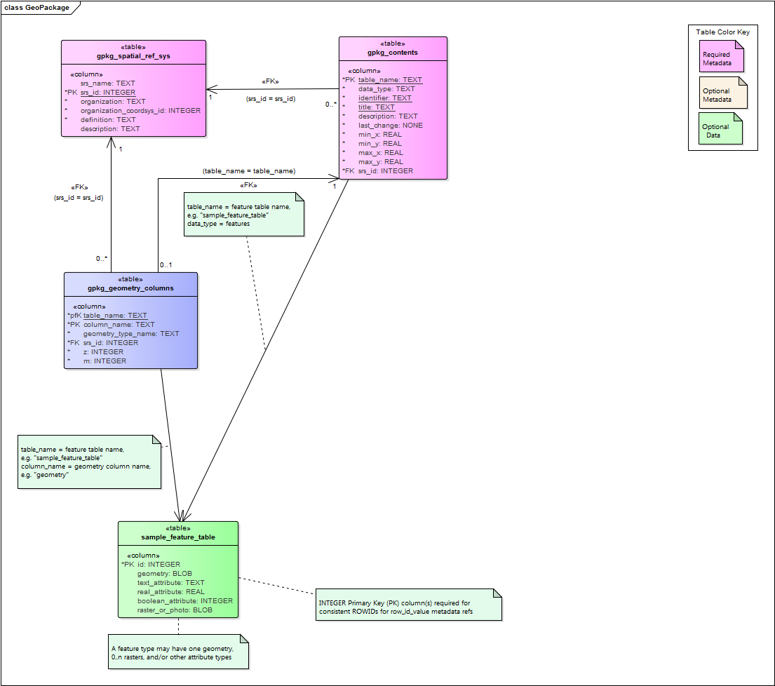
Figure 1: UML Diagram of Features tables
gpkg_geometry_columns
The gpkg_geometry_columns table describes the geometry for a particular Features table.
Each feature table must have a corresponding row in this table. The required columns in this table are:
table_nameandcolumn_namewhere the geometries are storedgeometry_type_namesrs_idthe spatial reference system (seegpkg_spatial_ref_sysabove)zandmare flags to indicate 3D/4D applications (Z values are for height/elevation/depth and M values are reserved for other types of domain-specific measurements)
User-defined Data Tables
Features are stored in user-defined data tables. Each features table has exactly one geometry column, a BLOB. (The structure of this BLOB is described here.) The OGC Simple Features geometry types are the supported geometry types. Other than the geometry column and a primary key, the schema of a features table is up to the implementer. Properties (text, integer, or real) provide additional information about each feature. The GeoPackage standard has an example schema.
Tiles
The GeoPackage Tiles option specifies a mechanism for storing raster data in tile pyramids. “Tile pyramid” refers to the concept of pyramid structure of tiles of different spatial extent and resolution at different zoom levels, and the tile data itself. “Tile” refers to an individual raster image such as a PNG or JPEG that covers a specific geographic area. “Tile matrix” refers to rows and columns of tiles that all have the same spatial extent and resolution at a particular zoom level. “Tile matrix set” refers to the definition of a tile pyramid’s tiling structure. This mechanism is based on the model for tile matrix sets described in Section 6 of the WMTS Implementation Specification.
If tiles are to be included in a GeoPackage, there are two additional required metadata tables, gpkg_tile_matrix_set and gpkg_tile_matrix.
In addition to these tables, each tile pyramid requires a user-defined table that contains the actual tiles.
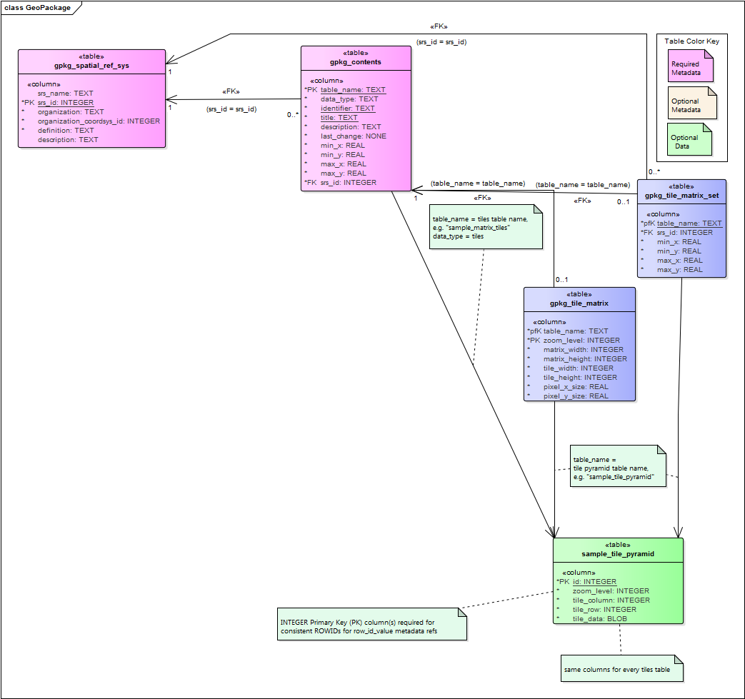
Figure 2: UML Diagram of Tiles tables
gpkg_tile_matrix_set
The gpkg_tile_matrix_set table describes names a tile matrix set (pyramid). The columns in this table are:
table_nameandsrs_idmatch the entries ingpkg_contentsmin_x,min_y,max_x, andmax_y: the actual spatial extents of the tile pyramid. This is must be exact so that applications can use this information to geolocate tiles correctly. (This is in contrast with the extents ingpkg_contentswhich are informative and are expected to reflect the extents of usable content.)
gpkg_tile_matrix
Each tile matrix set is composed of one or more tile matrices, each identified by its zoom level. The required columns in this table are:
table_namematches the entry ingpkg_contentsand elsewherezoom_levelindicates the zoom levels present in the file.matrix_widthandmatrix_heightdescribe the size of the tile matrix in tilestile_widthandtile_heightdescribe the size of each tile in pixelspixel_x_sizeandpixel_y_sizedescribe the size of each pixel
By default, zoom levels are separated by powers of two, but if this is inappropriate for your scenario, other multiples are possible by using the Zoom Other Levels extension.
User Data Tables
The physical tiles (data) are stored in user data tables with a specific schema. The required columns for these tables are:
idis a primary keyzoom_levelindicates which tile matrix this tile is part oftile_columnandtile_roware the zero-indexed tile numbertile_datais the BLOB containing the tile image
Unless you use an extension, PNG and JPG are the two supported file types for the tiles. PNG is generally better for synthetic data (i.e., digital maps) because it is lossless and its compression codec compresses synthetic data fairly well. JPG is generally better for natural data (i.e., satellite or aerial imagery) due to its superior (though lossy) compression. However, since PNG supports alpha transparency and JPG does not, it is common to use PNG tiles around the boundary of a tile pyramid. This allows users to see the data underneath the tile boundaries. JPG files have an adjustable compression rating. We have found that a ratings in the range 50-75 (out of 100) work best for imagery. Ratings that are too high use too much space and ratings that are too low have too many visible artifacts. Within the 50-75 range it is a reasonable tradeoff between file size and image quality.
Tile pyramids may be sparsely populated. This is a good way to manage GeoPackage size. Applications should be aware of this possibility and if possible, drop to the next zoom level to render that part of the map.
Attributes
Attributes are tables that only contain non-spatial data.
The rules for attributes are similar to those for features,
but attributes have no geometry column and the corresponding row in gpkg_contents has a data_type of “attributes”.
This data is commonly joined with spatial data as required by an application.
Extensions
In addition to tiles, features, and attributes, GeoPackage has a well-defined extension mechanism to support use cases that are not part of the core standard. A GeoPackage extension is a set of one or more requirements clauses that either profiles / extends existing requirements clauses in the GeoPackage standard or adds new requirements clauses. Existing requirement clause extension examples include additional geometry types, additional SQL geometry functions, and additional tile image formats. New requirement clause extension examples include spatial indexes, triggers, additional tables, other BLOB column encodings, and other SQL functions.
Files that use one or more extensions are by definition Extended GeoPackages.
There are two categories of extensions, registered and community.
gpkg_extensions
The extensions table describes the extensions that are in use in a GeoPackage. The columns for this table are:
table_nameis the name of the SQLite table where the extension appliescolumn_nameis the name of the SQLite column (in the referencedtable_name) where the extension applies (in some situations this isnull)extension_nameis the case sensitive name of the extension that is required, in the form<author>_<extension_name>(the author namegpkgis reserved for OGC adopted extensions)definitionis permalink, URI, or reference to a document that defines the extensionscopeis eitherread-write(for most extensions) orwrite-only(for extensions that can be used seamlessly by applications that are unaware of the extension as long as they operate in a read-only mode)
Registered Extensions
Registered extensions have been reviewed and adopted by OGC and are for all intents and purposes part of the standard. Most registered extensions are published as part of the core standard but they may be published independently as well.
The following extensions have been adopted by OGC:
- Non-Linear Geometry Types
- RTree Spatial Indexes
- Zoom Other Intervals
- Tiles Encoding WebP
- Metadata
- Schema
- WKT for Coordinate Reference Systems
- Tiled Gridded Coverage Data
- Related Tables Extension
Community Extensions
OGC acknowledges that there are use cases not covered by the GeoPackage standard. Implementers are welcome to use the extension mechanism defined here to develop community extensions. The extension mechanism provides advantages including discoverability (the extensions in use can be discovered by scanning a single table) and uniformity (declaring that an extension is in use indicates that a defined set of requirements are being met). However, this is a decision that should be made carefully as custom extensions do introduce interoperability risks. OGC manages a registry of community extensions.
OGC is unable to endorse community extensions. Therefore an Extended GeoPackage containing community extensions will not pass conformance tests. However, a community of interest MAY waive that requirement in its own GeoPackage profile, with the caveat that it must bear the responsibility of endorsing the new extension(s).
Implementers that are interested in developing their own extensions are encouraged to contact OGC to ensure that the extensions are developed in accordance with OGC policies and in a way that minimizes risks to interoperability. OGC will consider adopting externally developed extensions that address a clear use case, have a sound technical approach, and have a commitment to implementation by multiple implementers.